


Note: Click here for Friday's Cougar Peak Fire Updates
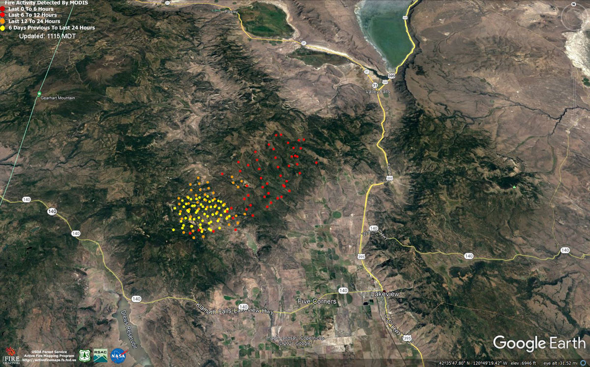
MODIS map of the Cougar Peak Fire on Thursday Morning
Note: 1,200 Pixels Wide - Note: Older Yellow not shown
MODIS Active Fire Mapping Program Frequently Asked Questions
Note: Click here for Friday's Cougar Peak Fire Updates
September 9, 2021 - Cougar Peak Fire Update for Thursday Morning, 25,000 acres with 0% containment.
Current Evac Map:
Evening Update
Lake County Sheriff’s Office:
Lakeview, OR – Evacuations. Evacuation Levels are being increased for the Cougar Peak Fire that is currently burning approximately 15 miles northwest of Lakeview on the Fremont-Winema National Forest because of current fire behavior, previously observed behavior, and anticipated Red Flag Weather impacts.
Please refer to the attached evacuation map for Evacuation Areas. The team continues to prepare drafts and evacuation orders, but the fire continues to grow much faster than anticipated. This is making it a challenge to prepare tedious evacuation maps before the fire reaches the next trigger point for the next area. Law Enforcement is going door-to-door in the affected area. LCSO has been utilizing OR-Alert to send messages to the homes in the areas. Please remain vigilant if you reside in these areas, officers may not have time to return to your home with new evacuation levels if the fire moves too quickly. You may want to consider moving livestock and animals in preparation of quick fire spread towards the Valley Falls and Clover Flat areas. Lake County has not established a livestock evacuation site yet. An evacuation center was established by the Red Cross today at the LDS Church located at HC 64 Hwy 395 N, Lakeview, OR 97630. Remember that: · Level 1 evacuation means “BE READY” for potential evacuation. Be aware of danger in your area and monitor emergency services websites and media outlets for information. Prepare yourself and belongings for evacuation and consider movement of persons with special needs, mobile property and pets and livestock. · Level 2 evacuation means “BE SET” to evacuate. Be ready to leave at a moment’s notice; there is a significant danger to your area. Residents may voluntarily relocate to a shelter or with family/friends outside the affected area. You may have time to gather necessary items, but doing so is at your own risk. · Level 3 evacuation means “GO NOW” – leave immediately! Danger is current or imminent. If you choose to ignore this advisement, understand that emergency services may not be able to assist you further. DO NOT delay to gather belongings or make efforts to protect your home.
Fire Information Fire Information Phone: (541) 900-5788 (8:00 am to 8:00 pm) E-mail: 2021.cougarpeak@firenet.gov
Evacuation Information: A Red Cross Evacuation Shelter has been established and is open at the LDS Church located at HC 64 Hwy 395 N, Lakeview, OR 97630
September 9, 2021 - Evening
Northwest Incident Management Team 8, Incident Commander Kevin Stock, joined Oregon State Fire Marshal (OSFM) Incident Management Blue Team, Scott Magers Incident Commander, in unified command, in management of the Cougar Peak Fire this morning. The incident command post is located at the Lake County Fairgrounds in Lakeview. The Conflagration Act has been invoked by Governor Brown which allows multi-agency structure protection resources to be mobilized from throughout the state to protect homes, businesses and critical infrastructure threatened by the Cougar Peak Fire. Taskforces (four to six engines and a water tender) have arrived from Clatsop, Lane, Linn, Yamhill, Clackamas and Marion Counties. Both Incident Management Teams appreciate the work completed to date by the South Central Oregon Fire Management Partnership (SCOFMP) Type 3 Incident Management Team and the smooth transition in managing of the Cougar Peak Fire.
General Updates: The Cougar Peak Fire was again very active today. The predicted southerly winds brought in gusts of up to 40 mph as the weather pattern moved through the fire area. It is estimated that the fire was close to doubling in size throughout the afternoon and by nightfall the fire had crossed over Clover Flat Road, making the fire an estimated 37,000 acres. Early in the day, resources worked to strengthen containment lines on the southern portion of the fire. Crews burned out dozer line and utilized existing road systems to strengthen and secure the southerly edge of the fire. Extreme winds proved to be challenging and the fire crossed into the Cottonwood Creek area. Crews continued to work the southern edge of the fire throughout the day working on establishing an anchor point. Early in the day air resources were able to help crews on the ground, with helicopter water drops and Single Engine Air Tankers laying retardant. Winds and smoke grounded air resources in the early afternoon. OSFM structure task forces with engines and water tenders began the day identifying structural protection needs around the fire. As wind moved through the fire area, resources were moved to the northern side of the fire to provide structural protection to ranches and property. Three task forces of 15 engines and 3 water tenders will remain out on the fire overnight. Resources will be working through the night to establish containment lines on both the southern and northern edges of the fire area. Burnout operations are planned on the southern front along State Hwy 31 and west of U.S. Hwy 395, south of Valley Falls.
Behavior:Critical fire spread was seen throughout the fire today. The potential of thunderstorms remains in the area through tomorrow afternoon, with the potential of creating erratic winds to fan the flames. Precipitation is expected throughout the evening into early Friday morning and winds are forecasted to be less than the last two days.
Acreage: 37,000 (estimated) Containment: 0% Cause: Under Investigation Fire Information: (541) 900-5788 (8:00 am to 8:00 pm) E-mail: 2021.cougarpeak@firenet.gov Information Websites: Facebook: “Cougar Peak Fire 2021” Inciweb: https://inciweb.nwcg.gov/incident/7835/
Air Quality: oregonsmoke.blogspot.com Weather: The Red Flag Warning remains in effect through 5 p.m. Friday for strong, gusty wind with low relative humidity and abundant lightning on dry fuels. The National Weather Service in Medford extended the end time of the Red Flag Warning, replacing the Fire Weather Watch.
Resources-361: 1-type 1 hand crew, 3-type 2 IA hand crews, 3-type 2 hand crews, 2- helicopters, 36-engines, 3-dozers, and 11-water tenders, and 1 masticator
Evacuations: Multiple Evacuation Levels have been issued by the Lake County Sheriff’s Office. See the website and Facebook for a full description of the evacuation levels. Link is below. https://www.lakecountyor.org/index.php https://www.facebook.com/Lake-County-Oregon-104435824529906
Temporary Flight Restrictions: A Temporary Flight Restriction is in place over the Cougar Peak Fire. Please consult the Notice to Airman for specifics. Wildfires are a No Drone Zone. If you fly, we can’t. Whenever a drone is spotted near the fire, all aircraft are grounded until we can be sure the drone is clear of the area. For more information, visit http://knowbeforeyoufly.org.
Fire Danger remains “Extreme” in Lake and Klamath counties. Extremely dry duels and seasonal winds can make even a small spark rapidly grow into a large wildlife. These fires can be very destructive. For the latest restrictions and regulations, including ODF and federal agencies, visit https://scofmp.org/restrictions.shtml. Make sure toKnow Before You Go. ###
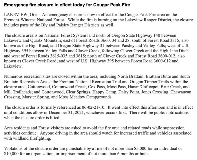
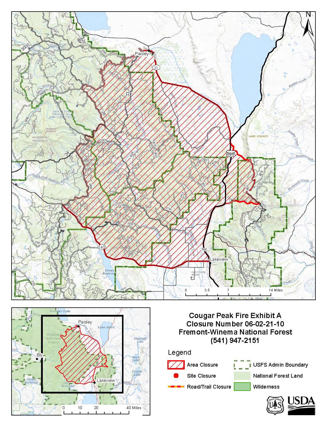
Updated Forest Closure
Cougar Peak Fire Update
Northwest Incident Management Team 8, Incident Commander, Kevin Stock
Oregon State Fire Marshal Incident Management Blue Team, Incident Commander, Scott Magers
September 9, 2021 - 8:00 AM
Northwest Incident Management Team 8, Incident Commander Kevin Stock, joined Oregon State Fire Marshal Incident Management Blue Team, Scott Magers Incident Commander, in unified command, in management of the Cougar Peak Fire this morning. The incident command post is located at the Lake County Fairgrounds in Lakeview. The Conflagration Act has been invoked by Governor Brown which allows multi-agency structure protection resources to be mobilized from throughout the state to protect homes, businesses and critical infrastructure threatened by the Cougar Peak Fire. Taskforces (four to six engines and a water tender) have arrived from Clatsop, Lane, Linn, Yamhill, Clackamas and Marion Counties. Both incoming incident management teams appreciate the work completed to date by the South Central Oregon Fire Management Partnership (SCOFMP) Type 3 Incident Management Team and the smooth transition in managing of the Cougar Peak Fire.
General Updates: The Cougar Peak Fire is burning approximately 15 miles northwest of Lakeview with columns of smoke and flames visible from Lakeview. The fire made a major push to the north and east burning into the Little and Big Baldy area. Resources worked into the night on the south flank constructing dozer line from the valley floor near Cox Creek to Forest Road 28 and from Lower Cottonwood to Forest Road 28. Dozer line on the west flank held. Today, firefighters will scout opportunities on the north and northwest flank for road prepping locations to be used as containment line and strengthening and securing established line. The structural protection group will be working on the west, southwest, and near the Open A Ranch area to identify and assess structure protection opportunities. Firefighters are utilizing a placard system to provide real time information to firefighting resources regarding prevention preparations, protection needs of the home or property, and other critical information including water sources. This information is posted at the beginning of driveways and is vital for first responders and their safety during firefighting operations. Residents may use the QR code on the placard to access a Frequently Asked Questions website. Behavior:Gusty winds, lack of overnight humidity recovery, and very low fuel moistures are creating the opportunity for a critical fire spread today with flames lengths up to 14 feet. Potential thunderstorms could also create erratic winds fanning the flames. Rapid runs in shorter fuels of grasses and sagebrush are anticipated.
Acreage: 25,000 (estimated) Containment: 0%
Cause: Under Investigation
Fire Information: (541) 900-5788 (8:00 am to 8:00 pm) E-mail: 2021.cougarpeak@firenet.gov Information Websites: Facebook: “Cougar Peak Fire 2021” Inciweb: https://inciweb.nwcg.gov/incident/7835/ Air Quality: oregonsmoke.blogspot.com
Weather: A Red Flag Warning is in effect from 1 p.m. Thursday to 9 a.m. Friday for strong, gusty wind and abundant lightning on dry fuels. A Fire Weather Watch is in effect from Friday morning through Friday afternoon for abundant lightning on dry fuels. Today will be partly cloudy in the morning then becoming cloudy in the afternoon. A slight chance of showers and thunderstorms in the afternoon. Maximum temperatures of 81 degrees with a minimum relative humidity of 22%. South winds will be 2 to 5 mph becoming southwest 10 to 20 mph with gusts to 30 to 40 mph in the afternoon. Gusty erratic winds are possible near any thunderstorms. Resources-253: 1-type 1 hand crew, 6-type 2 hand crews, 2 helicopter, 20-engines, 4-dozers, and 4-water tenders
Evacuations: Multiple Evacuation Levels have been issued by the Lake County Sheriff’s Office. See the website for a full description of the evacuation levels. Link is below. Lake County Website/Facebook Page: https://www.lakecountyor.org/index.php and https://www.facebook.com/Lake-County-Oregon-104435824529906
Temporary Flight Restrictions: Temporary Flight Restrictions: A Temporary Flight Restriction is in place over the Cougar Peak Fire. Wildfires are a No Drone Zone. If you fly, we can’t. Whenever a drone is spotted near the fire all aircraft are grounded until we can be sure the drone is clear of the area. For more information, visit http://knowbeforeyoufly.org.
Know before you go! Before going hunting, hiking or camping, be sure to check the forest, grassland or ranger district for fire restrictions or area closures. For a checklist of fire-safe actions when enjoying the outdoors, visit the Forest Service at Know Before You Go.
Basic Information
| Current as of | 9/9/2021, 10:34:04 AM |
| Incident Type | Wildfire |
| Cause | Undetermined |
| Date of Origin | Tuesday September 07th, 2021 approx. 01:45 PM |
| Location | 15 miles Northwest of Lakeview, Oregon |
| Incident Commander | Kevin Stock/USFS & Scott Magers/OSFM |
| Coordinates | 42.277 latitude, -120.613 longitude |
Current Situation
| Total Personnel | 253 |
| Size | 25,000 Acres |
| Estimated Containment Date | Tuesday October 05th, 2021 approx. 12:00 AM |
| Fuels Involved |
Timber (Litter and Understory) Brush (2 feet) Medium Logging Slash Predominate fuels are timber, dry climate brush, and logging slash with moisture contents that are at record lows. |
| Significant Events |
Extreme Running Torching Long-Range Spotting |
Outlook
| Planned Actions |
Extended Attack will continue through the night with the current available resources. The Type 2 IMT will assume Command at 0630 in the morning (09-09-2021) and resources are continuing to be ordered and mobilized as quickly as possible. |
| Projected Incident Activity |
12 Hours: Current fire behavior and record low dry fuels are making this Incident extremely resistant to control tactics and processes. The Type 2 IMT has already In-Briefed and will take Command at 0630 in the morning (09-09-2021). Smoke and weather obscurations have kept the Air Assets mostly at bay today. 24 Hours: Current on-scene resources and incoming/ordered resources will continue to engage this incident throughout tonight. Air assets will resume attack tomorrow (09-09-2021) if smoke coverage doesn't impede acceptable visibility requirements. |
| Remarks |
There has been some UNVERIFIED information cycling around regarding a minimal number of actual residents who have been displaced or evacuated, but a quantitative number has not been presented. |
Current Weather
| Weather Concerns |
Strong, gusty winds and dry humidities are expected today east of the Cascades with critical fire weather conditions across eastern fire weather zone 624 and much of zone 625. On Thursday, low pressure will approach then move inland by Friday. Expect strong, gusty winds east of the Cascades Thursday with relatively dry humidities. Isolated to scattered showers and thunderstorms may also develop from the Cascades east Thursday afternoon and evening. These storms may be mainly dry with strong, gusty outflow winds. The chance for thunderstorms increases Thursday night through Friday afternoon with scattered thunderstorms possible from the western foothills of the Cascades eastward. These storms are expected to have some rainfall along with abundant lightning and gusty outflow winds. Current Conditions: 73°, 26%, W/V: ESE @ 2 mph, gusts to 3 mph. FIRE WEATHER WATCH IN EFFECT FROM THURSDAY AFTERNOON THROUGH FRIDAY AFTERNOON FOR STRONG GUSTY WIND WITH LOW RH AND ABUNDANT LIGHTNING ON DRY FUELS Tonight..............Mostly cloudy with smoke. Min temperature.......45-55 Max humidity..........55-75 percent 20-foot winds............West 5 to 15 mph with gusts to around 25 in the evening becoming light. Ridges/upr slopes....West 8 to 18 mph with gusts to around 30 shifting to the south 5 to 8 after midnight. Haines ..........3 LAL...................1. Thursday..............Partly cloudy with smoke. Max temperature.......85-90 Min humidity..........15-25 percent. 20-foot winds............Light, becoming south 6 to 12 mph with gusts to around 25 in the afternoon. Ridges/upr slopes....South 10 to 20 Gusts up to 40 mph. Haines ..........4 LAL...................1. |
Cougar Peak Fire burning northwest of Lakeview
The Cougar Peak Fire is was discovered at 1:45 p.m. on Tuesday, September 7, and is currently burning approximately 15 miles northwest of Lakeview on the Fremont-Winema National Forest, Lakeview Ranger District.
Smoke from the fire is highly visible along Oregon State Highway 140 between Lakeview and Quartz Mountain, as well as along U.S. Highway 395. Drivers should use caution in the area due to increased traffic from wildland firefighting equipment.
The Lake County Sheriff’s Office of Emergency Management and the Incident Commander have identified areas for Level 3 (Go Now) and Level 1 (Be Ready) Evacuations in the fire area.
Lake County Evacuations
Level 3 Evacuation Notice (GO NOW – Residents should leave IMMEDIATELY.)
• Lower Cottonwood Road north to Forest Road 3870-041.
Level 1 (GET READY – Residents should make preparations for potential evacuation.)
• Forest Road 28, from the Forest Boundary northwest to Cox Flat.
Area residents and visitors are reminded that Public Use Restrictions are still in effect on the Fremont-Winema National Forest, as well as fire restrictions in effect on neighboring landscapes.
Fire danger remains “Extreme” in Lake and Klamath counties. Extremely dry fuels and seasonal winds can make even a small spark rapidly grow into a large wildfire. These fires can be destructive, resulting in evacuations, damage to property and natural resources, and affects public and firefighter safety.
