


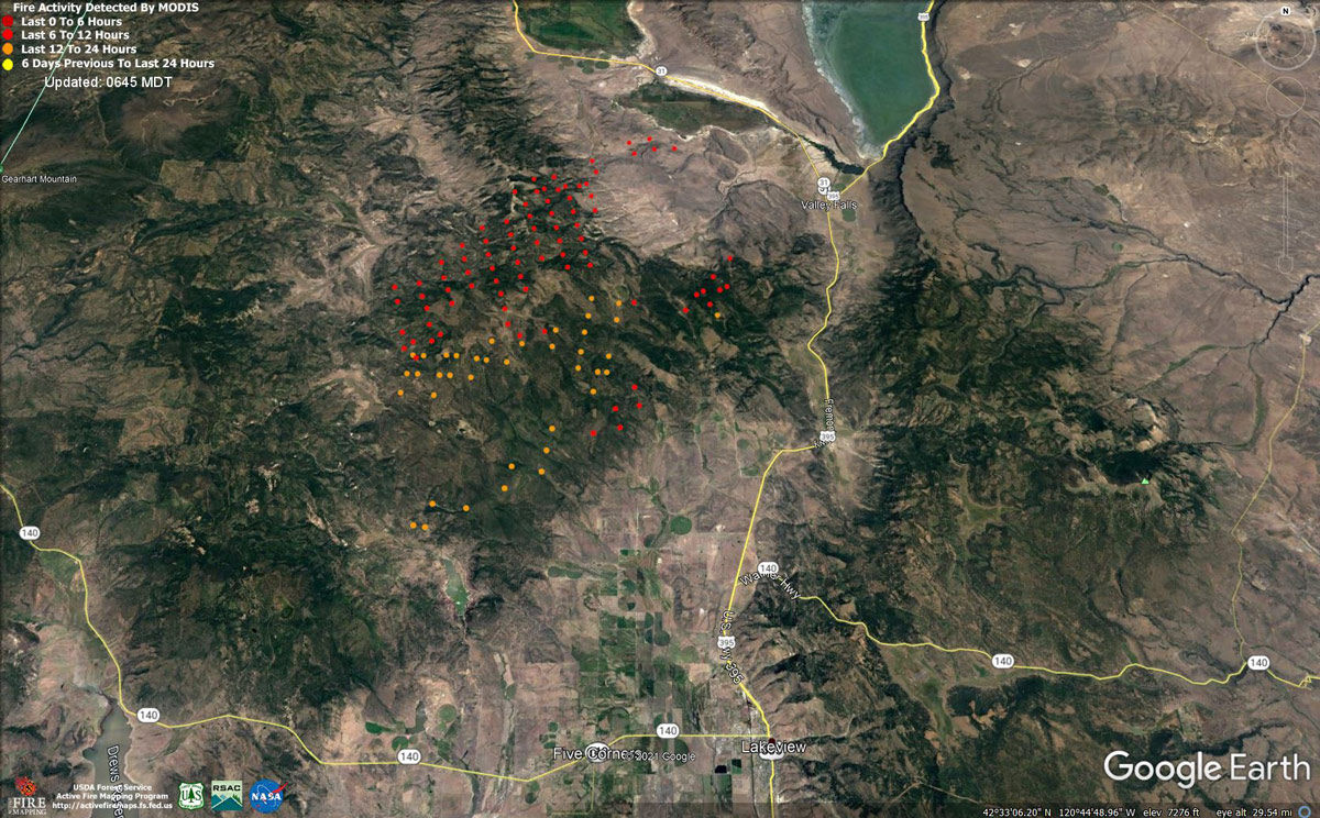
MODIS map of the Cougar Peak Fire on Friday Morning
Note: 1,200 Pixels Wide - Note: Older Yellow not shown
MODIS Active Fire Mapping Program Frequently Asked Questions
Update: Oregon Cougar Peak Fire Virtual Community Update Evening Video for Friday, September 10, 2021
Cougar Peak Fire Evening Update for Friday, September 10, 2021
Northwest Incident Management Team 8, Incident Commander, Kevin Stock
Oregon State Fire Marshal Incident Management Blue Team, Incident Commander, Scott Magers
September 10, 2021 – Evening
Northwest Incident Management Team 8, Incident Commander Kevin Stock, in unified command with Oregon State Fire Marshal (OSFM) Incident Management Blue Team, Scott Magers Incident Commander, in managing the Cougar Peak Fire.
General Updates: The Cougar Peak Fire's southern edge is approximately 15 miles northwest of Lakeview and the most northern flank has crossed over Clover Flat Rd.
Early this morning, the fire area and most of South Central Oregon were subject to a band of moisture that moved northward from California. The fire area continued to receive significant rain fall throughout the day as thunderstorms moved through.
The moisture has allowed firefighters to make significant progress on anchoring the fire on the southeast corner. Three dozers constructed line on the southern and eastern flanks today toward the north as a dozer and hand crews worked south from Cox Creek. Resources are focusing on working as close to the fire’s edge as possible. As fuels dry, crews will burnout the areas to create secure containment lines. Engines and crews continued to mop up both the containment lines and area around structures throughout the fire area. The western edge of the fire is burning through some snag patches of a previous burn. Firefighters continue to scout the area for containment opportunities.
The increase in moisture and minimal five activity today gave resources safer entry into drainages on the eastern side of the fire area. OSFM resources continued the evaluation and protection of property, working into areas they could not access during yesterday’s extreme fire behavior. In Clover Flats where multiple ranches reside, contingency lines were completed, and mop-up operations continued to better secure the area.
Tonight, four tasks forces consisted of 20 engines and 4 water tenders will continue working throughout the night, mopping up and protecting structures.
Behavior: Anticipated fire spread will be minimal throughout the night, as humidity is expected to recover to 70-90%, and temperatures will dip in to the 40’s. As the temperatures ease back into seasonal norms, fire behavior will likely increase over the weekend.
Acreage: 83,339
Containment: 0%
Cause: Under Investigation
Fire Information: (541) 900-5788 (8:00 A.M. to 8:00 P.M.)
E-mail: 2021.cougarpeak@firenet.gov
Information Websites: Facebook: “Cougar Peak Fire 2021”
Inciweb: https://inciweb.nwcg.gov/incident/7835/
Air Quality: oregonsmoke.blogspot.com
Weather: The focus for showers and thunderstorms shifts northeast this evening, with dry conditions returning tonight and lasting into next week. Light winds tomorrow afternoon may cause smoke to push southeast, blowing smoke into the Lakeview area.
In some years, the amount of rain we have received at this time of year could be considered a season ending event. This season, however, is not a typical season. This area is in its second consecutive year of drought and entered this fire season in the highest classification of drought measure possible. Likewise, fuel moistures have been at or near record lows for most of the year. Just as today’s rains will not fill our empty reservoirs, it will also not automatically bring an end to this fire season.
The next week will bring sunny skies back to the area and the critically dry fuels will respond rapidly to the solar radiation. The primary carriers of the fire in timbered areas are the kindling sized branchwood and conifer needles and will be capable of moderate fire spread within a few days. The grass component will be capable of carrying fire within a few days as well. There is a lot of fire on the landscape and still a lot of potential as well.
Resources-694: 1 - type 1 hand crew, 3 - type 2 IA hand crews, 11 - type 2 hand crews, 2- cap crews, 3 - heavy lift helicopters, 2-medium lift helicopters, 1 - light lift helicopter, 64 engines, 10 dozers, 19 water tenders, and 2 masticators.
Evacuations: Multiple Evacuation Levels have been issued by the Lake County Sheriff’s Office. See this link for entering a specific address in the upper right corner in this interactive map:
https://geo.maps.arcgis.com/apps/PublicInformation/index...
See the website and Facebook for a full description of the evacuation levels.
Temporary Flight Restrictions: A Temporary Flight Restriction is in place over the Cougar Peak Fire. Please consult the Notice to Airman for specifics.
Red Cross Evacuation Shelter: The Lakeview shelter and planned emergency shelter in LaPine will both be on standby starting Saturday. If the need arises, staff are available to reopen the shelter. Wildfires are a No Drone Zone. If you fly, we can’t. Whenever a drone is spotted near the fire, all aircraft are grounded until we can be sure the drone is clear of the area.
For more information, visit http://knowbeforeyoufly.org.
An average of 85% of fires in the Pacific Northwest are started by humans. Please continue to do your part and be fire aware, know fire restrictions in areas you are visiting and practice safe summer outings! #OnlyYouCanPreventWildfires
For the latest restrictions and regulations, including Oregon Department of Forestry and federal agencies, visit https://scofmp.org/restrictions.shtml. Make sure to Know Before You Go.
Update: Oregon Cougar Peak Fire Infrared Map for Friday, September 10, 2021 - Interpreted Size: 83,339 Acres
September 10, 2021 - Cougar Peak Fire Update for Friday Morning, 83,339 acres.
Update: 1:15 P.M.
Cougar Peak Fire Virtual Community MeetingSept. 10 at 5:00PM Facebook Live - 2021 Cougar Peak fire
Update 1:00 P.M.
Status of the Cougar Peak Fire
Fire Behavior Analyst – Jim Hampton
On Friday, September 10, the Cougar Peak Fire and most of South-Central Oregon was subject to a band of moisture that moved from northward from California. Precipitation amounts over the region varied widely, from 1/10” to over half an inch. A good estimate of the precipitation received over the fire area is a quarter inch.
In some years, this amount at this time of year could be considered a season ending event. This season, however, is not a typical season. This area is in its second consecutive year of drought and entered this fire season in the highest classification of drought measure possible. Likewise, fuel moistures have been at or near record lows for most of the year. Just as today’s rains will not fill our empty reservoirs, it will also not automatically bring an end to this fire season.
The next week will bring sunny skies back to the area and the critically dry fuels will respond rapidly to the solar radiation. The primary carriers of the fire in timbered areas are the kindling sized branch wood and conifer needles and will be capable of moderate fire spread within a few days. The grass component will be capable of carrying fire within a few days as well. There is a lot of fire on the landscape and still a lot of potential as well.
September 10, 2021 – Morning
Virtual Community Meeting this evening at 5:00 – Facebook Live
Northwest Incident Management Team 8, Incident Commander Kevin Stock, in unified command with Oregon State Fire Marshal (OSFM) Incident Management Blue Team, Scott Magers Incident Commander, is managing the Cougar Peak Fire. The incident command post is located at the Lake County Fairgrounds in Lakeview. The Conflagration Act has been invoked by Governor Brown which allows multi-agency structure protection resources to be mobilized from throughout the state to protect homes, businesses and critical infrastructure threatened by the Cougar Peak Fire.
General Updates: The Cougar Peak Fire is burning approximately 15 miles northwest of Lakeview. After significant fire activity yesterday along the northeast perimeter, the wetting rains over the fire early this morning considerably moderated fire behavior. Today will be a favorable day for firefighters, as the rain has cooled the fire’s edge and will allow for more direct operations along the perimeter. An infrared reconnaissance flight last night provided a more accurate fire acreage. Yesterday began with extreme fire behavior, including a pyro-cumulonimbus development pushing out 10-11 miles along the northern boundary of the fire. Firefighters focused efforts to keep ahead of the fire to provide structure and property protection. Contingency lines were constructed at the northeast side to provide structure protection to Valley Falls. At dark, when the winds dropped, the fire reached the flats just south of the Chewaucan Marsh and checked the forward movement. There was very little lateral growth on the east and west flanks of the fire due to the growth being wind driven. Dozer line work continues on the southern edge in efforts to create an anchor point for resources. Today, crews will focus work on eastern flank of the fire. The precipitation received will allow dozers and handcrews to use a direct tactic and build containment line next to the fire’s edge.
The Oregon State Fire Marshal’s mobilized additional incident management staff and four more taskforces yesterday, bringing the total of structural protection taskforces to ten.
Structural firefighters will capitalize on morning precipitation to access areas of the fire that were previously inaccessible due to active fire behavior. Focuses for today will be evaluating and protecting structures and engaging directly with fire lines that threatened homes.
Behavior:Anticipated fire spread will be minimal today, due to the moderate weather. As the temperatures ease back into seasonal norms, fire behavior will likely increase over the weekend.
Acreage: 83,339 (estimated) Containment: 0% Cause: Under Investigation
Fire Information: (541) 900-5788 (8:00 am to 8:00 pm) E-mail: 2021.cougarpeak@firenet.gov
Information Websites: Facebook: “Cougar Peak Fire 2021” Inciweb: https://inciweb.nwcg.gov/incident/7835/
Air Quality: oregonsmoke.blogspot.com
Weather: The Red Flag Warning remains in effect through 5 p.m. today, for strong, gusty winds with low relative humidity and abundant lightning on dry fuels. Later today, the focus for showers and thunderstorms shifts northeast with dry conditions returning tonight and lasting into next week. The maximum temperature forecasted for today will be in the upper 60s. Southwest winds 3-6 mph with gusts up to 10 mph will become westerly 4-7 mph with gusts up to 12 mph in the afternoon. Erratic and gusty winds up to 20 mph can be expected near thunderstorms.
Resources-412: 1 - type 1 hand crew, 2 - type 2 IA hand crews, 3 - type 2 hand crews, 2 - heavy lift helicopters, 1 - light lift helicopter, 36 engines, 3 dozers, 11 water tenders, and 1 masticator
Evacuations: Multiple Evacuation Levels have been issued by the Lake County Sheriff’s Office. See this link for entering a specific address in the upper right corner in this interactive map:
https://geo.maps.arcgis.com/apps/PublicInformation/index.html?appid=f8a0d8814a67445a9e6bf3485f4fd24f See the website and Facebook for a full description of the evacuation levels. Link is below. https://www.lakecountyor.org/index.php https://www.facebook.com/Lake-County-Oregon-104435824529906
Temporary Flight Restrictions: A Temporary Flight Restriction is in place over the Cougar Peak Fire. Please consult the Notice to Airman for specifics. Wildfires are a No Drone Zone. If you fly, we can’t. Whenever a drone is spotted near the fire, all aircraft are grounded until we can be sure the drone is clear of the area. For more information, visit http://knowbeforeyoufly.org.
Despite the recent rain received, extremely dry fuel conditions and seasonal winds can make even a small spark rapidly grow into a large wildlife. These fires can be very destructive.
For the latest restrictions and regulations, including ODF and federal agencies, visit https://scofmp.org/restrictions.shtml. Make sure to Know Before You Go.
Basic Information
| Current as of | 9/10/2021, 9:15:02 AM |
| Incident Type | Wildfire |
| Cause | Undetermined |
| Date of Origin | Tuesday September 07th, 2021 approx. 01:45 PM |
| Location | 15 miles Northwest of Lakeview, Oregon |
| Incident Commander | Kevin Stock/USFS & Scott Magers/OSFM |
| Coordinates | 42.277 latitude, -120.613 longitude |
Current Situation
| Total Personnel | 361 |
| Size | 83,339 Acres |
| Estimated Containment Date | Tuesday October 05th, 2021 approx. 12:00 AM |
| Fuels Involved |
Timber (Litter and Understory) Brush (2 feet) Medium Logging Slash Predominate fuels are timber, dry climate brush, and logging slash with moisture contents that are at or near record lows. |
| Significant Events |
Extreme Crowning Wind Driven Runs Spotting |
Outlook
| Planned Actions |
Provide Rural Structure Protection. Continue to establish anchor points near Div A-Z division break and near Hwy 31 Hwy 395 jct (Valley Falls). Scout for opportunities to connect Divisions M and A. Continue to scout and prep roads west of Clover Flats and Highway 31. |
| Projected Incident Activity |
12 hours: Current fire behavior and record low dry fuels are making this Incident extremely resistant to control tactics and processes. The northeast progression is expected to continue through the evening, pushed by a strong southwesterly flow. Thunderstorm outflow winds have the potential to move the fire rapidly in several directions. 24 hours: Easterly movement of the fire is likely today. The embedded shortwave within the trough passage brings an increased probability of precipitation Friday morning. The resulting fire behavior for this period will depend on the amount and duration of any precipitation. 48 hours: Typical NW flow returns to the fire area. Torching runs, active surface fire, moderate spotting distance and a high probability of ignition is expected to continue. Easterly movement of the fire will continue. 72 hours: Typical NW flow returns to the fire area. Torching runs, active surface fire, moderate spotting distance and a high probability of ignition is expected to continue. Easterly movement of the fire will continue. Anticipated after 72 hours: Typical NW flow returns to the fire area. Torching runs, active surface fire, moderate spotting distance and a high probability of ignition is expected to continue. Easterly movement of the fire will continue. |
Current Weather
| Weather Concerns |
On Thursday, low pressure will approach then move inland by Friday. Expect strong, gusty winds east of the Cascades Thursday with relatively dry humidities. Isolated to scattered showers and thunderstorms may also develop from the Cascades east Thursday afternoon and evening. These storms may be mainly dry with strong, gusty outflow winds. The chance for thunderstorms increases Thursday night through Friday afternoon with scattered thunderstorms possible from the western foothills of the Cascades eastward. These storms are expected to have some rainfall along with abundant lightning and gusty outflow winds. FIRE WEATHER WATCH IN EFFECT FROM THURSDAY AFTERNOON THROUGH FRIDAY AFTERNOON FOR STRONG GUSTY WIND WITH LOW RH AND ABUNDANT LIGHTNING ON DRY FUELS |
Click here for: Oregon Cougar Peak Fire Thursday, September 9, 2021 Updates
