


Note: Click here for Thursday's Caldor Fire Updates
Caldor Fire West Zone Evening Update Video
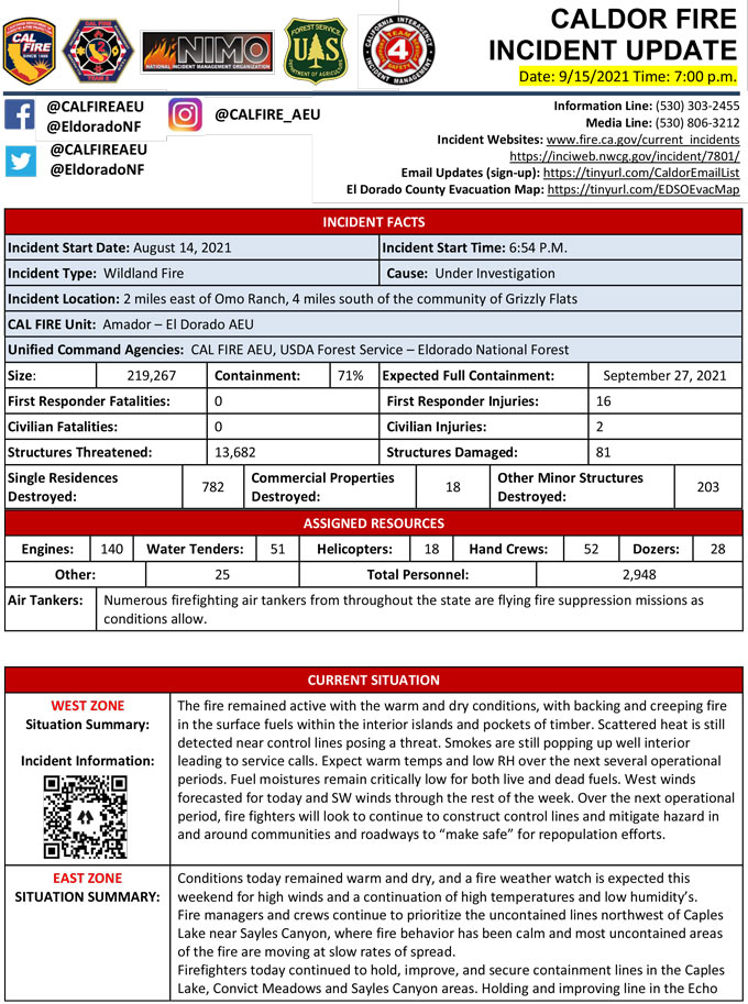
Evening Update Per CAL FIRE: California Caldor Fire is at 219,267 Acres, with 71% Containment, and 2,948 personnel assigned for Wednesday evening.
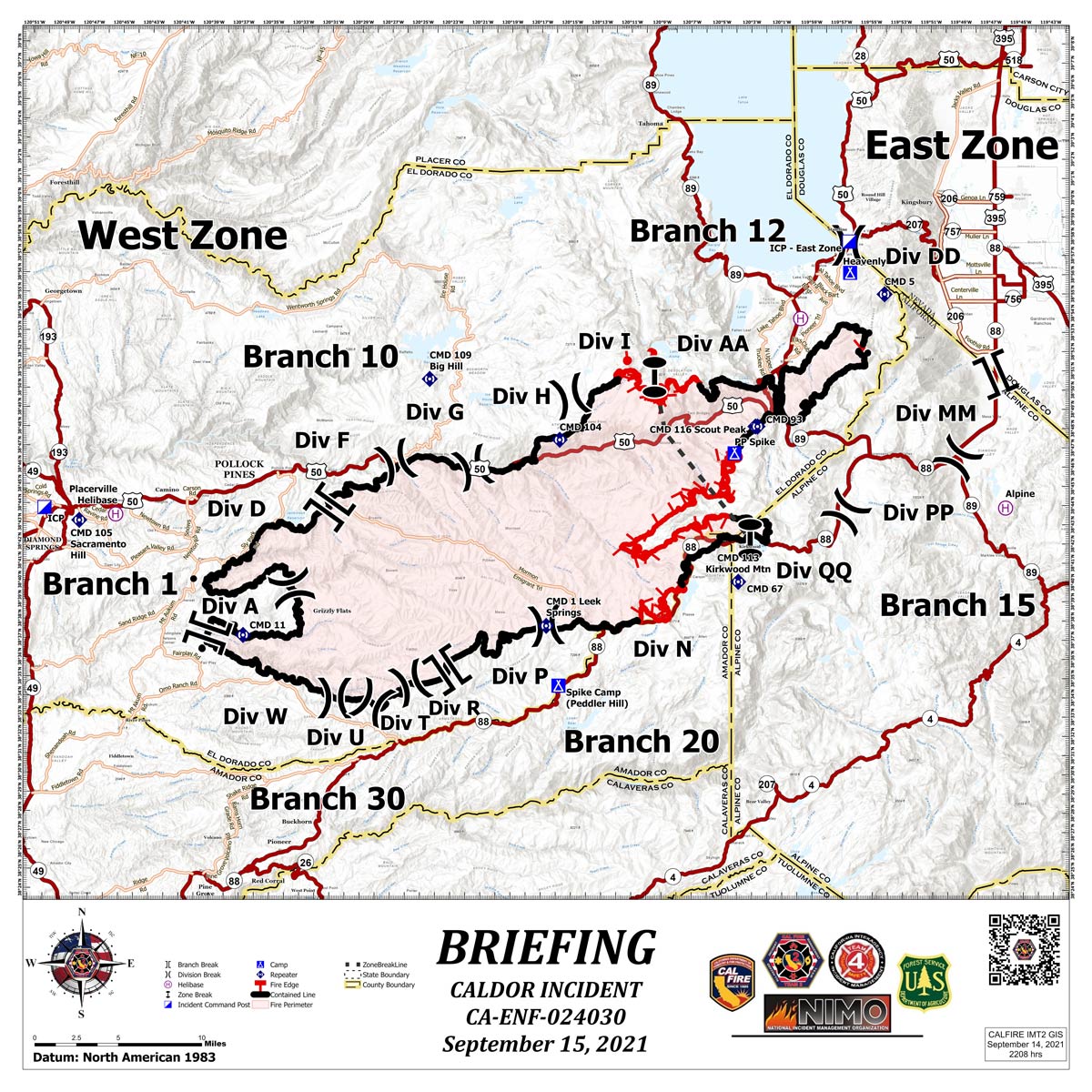
Briefing Map Shows Divisions, Uncontrolled Fire Edge, Completed Dozer Lines.
Note: Map is 1,200 pixels wide.
Caldor Fire Morning Operational Video
Evacuation Orders Downgraded - Effective Immediately for El Dorado County (1:00 P.M.)
Evacuation Order Update:
The following Evacuation warnings have been lifted in El Dorado County:
Fallen Leaf B:
• North Fallen Leaf Lake
• Cascade Lake
• Tahoe Mountain residents, extending west to the border of Desolation Wilderness and south of Highway 89.
• Spring Creek residents from Cathedral Road extending west to the middle of Fallen Leaf Lake.
Pioneer:
• North of Elks Club along Highway 50 and the west side Pioneer Trail, excluding the residences west of the airport.
• All residences accessed from Hekpa Drive, Jicarilla Drive, Susquehana Drive, Washoan and Glen Eagles Road.
• Neighborhoods of Golden Bear, Cold Creek Trail, High Meadows, and Marshall Trail
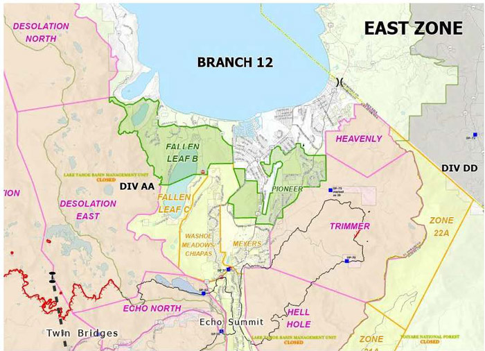
East Zone Map: Red area indicates Evacuation.
Yellow area indicates Evacuation downgraded to Warning.
Green area indicates evacuation order lifted.
Evacuation Update - El Dorado County Caldor Zone (10:00 A.M.)
The following Evacuation Orders have been downgraded to Evacuation Warnings in El Dorado County:
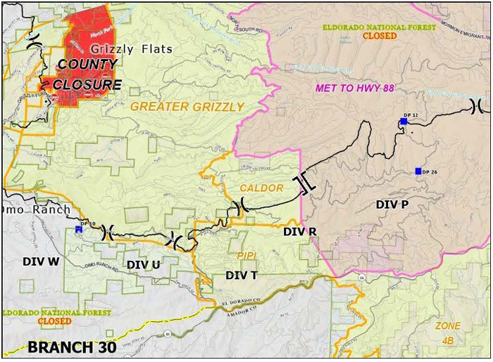
Caldor – From Plummer Ridge south through North South Road including the western portions of Cat Creek and Lower Cat Creek Road.
West Zone Map: Red area indicates Evacuation.
Yellow area indicates Evacuation downgraded to Warning.
September 15, 2021 - Caldor Fire Update for Wednesday Morning, 219,267 Acres with 70% Containment.
Basic Information
| Current as of | 9/15/2021, 7:01:54 AM |
| Incident Type | Wildfire |
| Cause | Under Investigation |
| Date of Origin | Saturday August 14th, 2021 approx. 07:00 PM |
| Location | Two miles East of Omo Ranch, four miles South of Grizzly Flat |
| Incident Commander | Charlie Blankenheim, CAL FIRE IMT2; Joe Reinarz, USFS NIMO 2; Rocky Opliger, ICT1, USFS CIIMT4 |
| Incident Description | Vegetation |
| Coordinates | 38.586 latitude, -120.538 longitude |
Current Situation
| Total Personnel | 3,010 |
| Size | 219,267 Acres |
| Percent of Perimeter Contained | 70% |
| Estimated Containment Date | Monday September 27th, 2021 approx. 06:00 PM |
| Fuels Involved |
Timber (litter and understory) Light logging slash Brush (2 feet) |
| Significant Events |
The fire remained active overnight. Fuels continued to smolder and creep away from control lines. RH recovery overnight moderated fire behavior some, however large diameter dead and downed fuels continued to smolder and burn down. Expect warm temps and low RH over the next several operational periods. Fuel moistures remain critically low for both live and dead fuels. West winds forecasted for tomorrow and SW winds forecasted through most of next week. SW winds are associated with large fire growth. The Energy Release Component is just below the 97th percentile. The Burning Index is below the 97th percentile. Potential for wind driven surface fire and torching due to alignment. |
Outlook
| Planned Actions |
WEST ZONE: Provide for the life safety of citizens and emergency responders. Implement structure and critical infrastructure defense. Construct control lines and take advantage of targets of opportunity as allowed by fire behavior and resource availability. Improve and hold established control lines. Mitigate hazards in and around communities and roadways to "make safe" for repopulation. Thorough mop up and tactical patrol of perimeter contained. Thorough mop-up, backhaul of hose, and tactical patrol will continue in all West Zone Branches. Crews will continue to strengthen and improve control lines in Branch 10 and 20. In DIV N, crews will cut direct and indirect line. MIST tactics will be used in the Desolation Wilderness. Fire Suppression Repair continues to evaluate repair needs and will implement the Incident's Fire Suppression Repair Plan. EAST ZONE: From Highway 89 west to Scout Peak, crews will remain engaged in strengthening direct containment lines with mop up to reduce the threat to structures. In the Christmas Valley area, resources will continue to patrol and mop up as necessary. On the northeastern side of the fire, resources will strengthen existing fireline and continue to use direct tactics. On the southern flank of the eastern finger of the fire, a combination of direct hand and dozer line has been completed to keep fire from moving to the south and east. Crews will continue to mop up and secure the line. In the northwest part of the zone, west of Upper and Lower Echo lakes, crews will continue to construct direct fireline toward Pyramid Peak. In the Lower and Upper Echo Lake areas, mop up and patrol continues. Crews patrolled the fireline area to the southwest in the Scout Peak area. Direct line construction continues to the southwest. Crews are constructing direct line to the east and to the west from the DP 68, in the Strawberry Creek area. In the Caples Lake area crews will hold the line, mop up, and extend fireline past the zone break. |
| Projected Incident Activity |
WEST ZONE: Fuels will continue to smolder and creep in the surface fuels within the interior islands and pockets of timber. Increasing winds will raise the potential for more active fire behavior in the unburned islands and timber stringers Areas of the fire have experienced needle and leaf drop which may allow creeping fire through this layer. EAST ZONE: Temperatures will be in the 80s. Forecasted winds will be W 24 mph. Potential for wind driven surface fire, single tree torching and spotting. Instability over the incident with a Haines of 5. Moderate overnight recoveries will aid in line construction and managing spot fires. Local thresholds will be exceeded. Expect moderate fire behavior in DIV PP, DIV QQ and DIV November (West Zone). 24 hours: WEST ZONE: A weather pattern change will bring some moisture to the area but increasing winds will maintain the potential for more active fire behavior in the unburned islands and timber stringers. EAST ZONE: SW winds forecasted over the next several operational periods. Instability over the incident with a Haines of 5. Moderate overnight recoveries will aid in line construction and managing spot fires. Several local thresholds will be exceeded. Expect moderate fire behavior in DIV PP, DIV QQ and DIV November (West Zone). |
| Remarks |
A Fire Management Assistance Declaration was declared on August 17, 2021. Incident Period: August 14, 2021, and continuing. (FM-5413-CA) The Governor of California declared a State of Emergency for El Dorado County on August 17, 2021, due to the Caldor Fire. The Eldorado National Forest is closed from August 17, 2021, through September 30, 2021 (Forest Order No. 03-21-14). To better provide public and firefighter safety due to the ongoing California wildfire crisis, USDA Forest Service Pacific Southwest Region announced a temporary closure of all National Forests in California from August 31, 2021 through September 17, 2021. CAL FIRE IMT-2 and NIMO-2 are in command of the West Zone and CIIMT-4 is in command of the East Zone. CIIMT-12 has been assigned to the Caldor and in-briefed today at 1600 hours. A tentative transfer of command is scheduled for 9/17 at 0700 hours. Fuels reduction projects that have been implemented around the community of South Lake Tahoe have been highly effective in providing opportunities for resources to successfully suppress fire. |
Current Weather
| Weather Concerns |
Observations: Winds over the majority of the fire area became downslope as the sun set with speeds around 3 to 5 mph. Temperature inversions developed overnight with poor humidity recoveries in the thermal belts and along the ridges with good recoveries in the valleys. Temperatures in the valleys dropped into the 30s with 40s and low 50s in the upper elevations. Wednesday Forecast: Temperatures will remain warm on Wednesday with high temperatures again reaching into the upper 70s and low 80s. Dry air will remain over the region with humidity's dropping back into the teens and low 20s with poor overnight recoveries above around 6800'. Winds will be terrain driven over most of the fire area gusting up to 15 mph with light westerly ridge winds in the morning gusting to around 25 to 30 mph in the late afternoon. |
Click here for: California Caldor Fire Tuesday, September 14, 2021 Updates
