


Update: Caldor Fire Videos for Thursday, September 16, 2021
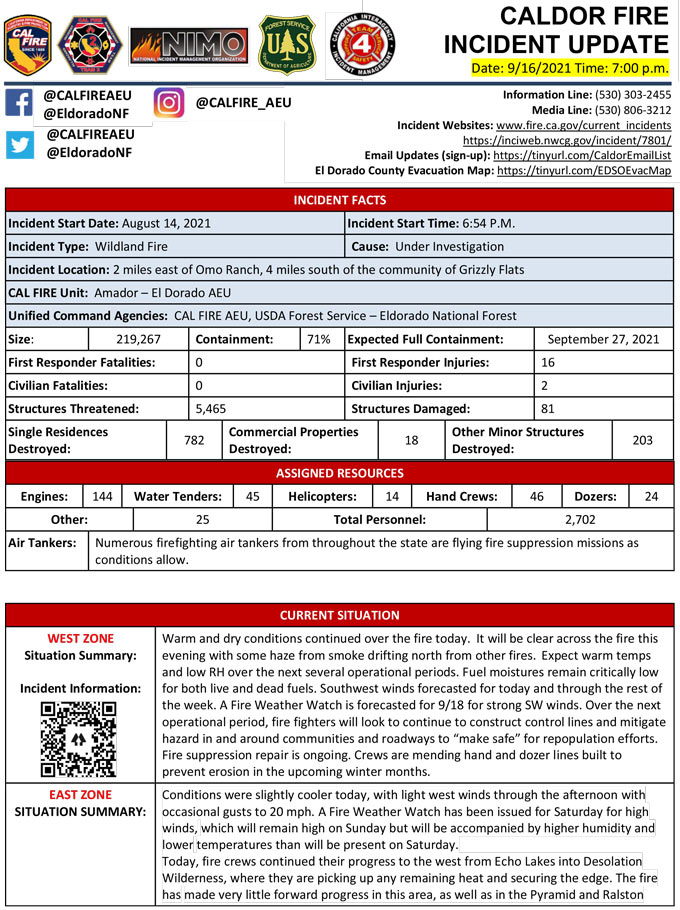
Evening Update Per CAL FIRE: California Caldor Fire is at 219,267 Acres, with 71% Containment, and 2,702 personnel assigned for Thursday evening.
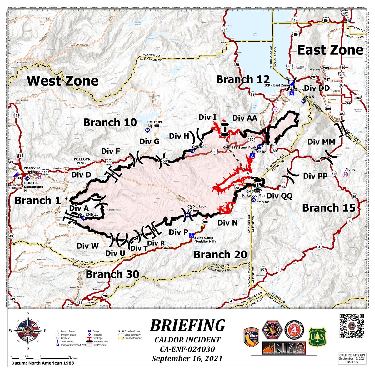
Briefing Map Shows Divisions, Uncontrolled Fire Edge, Completed Dozer Lines.
Note: Map is 1,200 pixels wide.
Update: Evacuation Orders Downgraded - Effective Immediately for El Dorado County, Amador County, Alpine County
Evacuation Order Update:
The following Evacuation Orders have been downgraded to Evacuation Warnings in Amador County: Zones 4A and 5A
• South of Highway 88 along the Amador/El Dorado County line from Dufrene Road, due east to the Amador/Alpine County line and from the Amador/Alpine County line north to Hwy 88.
The following Evacuation Warnings have been lifted in Amador County:
Zones 4B and 5B
• South of Dufrene Road due east to the Amador/Alpine County line. West of the of the Amador/Alpine County line and north of the Amador/Calaveras County line. Concluding with a western border of Panther Creek Road.
The following Evacuation Warnings have been lifted in Alpine County:
Zone 19 and 20
• Highway 88 Picket’s Junction south to Kirkwood and the Alpine/Amador County line.
• Wilderness and forested areas south of 88 and west of Blue Lakes.
The following Evacuation Warnings have been lifted in El Dorado County:
Zones referred on map as:
• SE Pollock
• Greater Grizzly
• Caldor
• Pipi
• Not including Grizzly Flats Proper
Please be careful in all areas as there is still work being done by emergency personnel. Drive slowly and be safe.
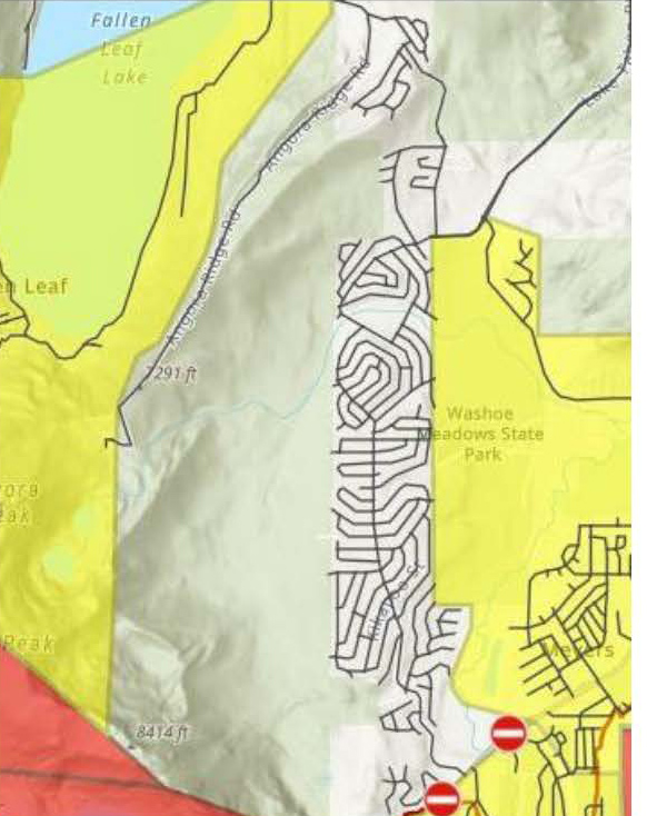
Update: Caldor Fire Evacuation Update for El Dorado County (Washoe Meadows) 1:00 P.M.
The following Evacuation warnings have been lifted in El Dorado County:
East Zone: Washoe Meadows area including all residences accessed from North Upper Truckee Road, Tahoe Mountain Road, Lake Tahoe Boulevard, west of Tahoe Mountain Road and Chiapa Drive.
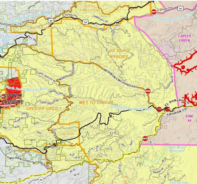
Update: Caldor Fire Evacuation Update for El Dorado County (9:00 A.M.)
The following Evacuation Orders have been downgraded to Evacuation Warnings in
El Dorado County:
- South of Mormon Emigrant Trail to Highway 88 and west on Highway 88 to Hams Station.
- South of Highway 50 from Ice House Road to Silver Fork Road, to include the community of Kyburz and east of Mormon Emigrant Trail to Highway 88.
Red area indicates Evacuation orders.
Yellow area indicates Evacuation downgraded to Warning.
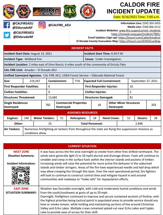
September 16, 2021 - Caldor Fire Update for Thursday Morning, 219,267 Acres with 71% Containment
Update CAL FIRE
Click here for: California Caldor Fire Wednesday, September 15, 2021 Updates
