


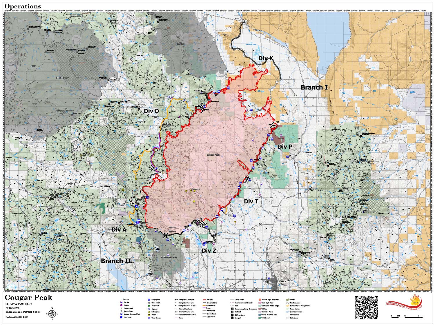
Map Shows Divisions, Uncontrolled Fire Edge, Completed Dozer Lines.
Note: Map is 1,500 Pixels Wide
September 16, 2021 - Cougar Peak Fire Update for Thursday Morning, 87,349 acres with 6% Containment.
Overnight Infrared Flight: Interpreted Size: 87,349 Acres a growth of 327 Acres over last flight.
Basic Information
| Current as of | 9/16/2021, 5:08:02 AM |
| Incident Type | Wildfire |
| Cause | Undetermined |
| Date of Origin | Tuesday September 07th, 2021 approx. 01:45 PM |
| Location | 15 miles Northwest of Lakeview, Oregon |
| Incident Commander | Kevin Stock NWIMT8 |
| Coordinates | 42.277 latitude, -120.613 longitude |
Current Situation
| Total Personnel | 845 |
| Size | 87,349 Acres |
| Percent of Perimeter Contained | 6% |
| Estimated Containment Date | Tuesday October 05th, 2021 approx. 12:00 AM |
| Fuels Involved |
Timber (Litter and Understory) Brush (2 feet) Medium Logging Slash Predominate fuels are timber, dry climate brush, logging and fuels reduction slash. |
| Significant Events |
Active; Uphill Runs; Torching; Spotting Narrative: Three consecutive days of low day and poor nighttime humidity, fire activity has picked up. Active surface fire with moderate surface fire with torching runs, high probability of ignition and moderate spotting distance. Spot fires difficult to contain. |
Outlook
| Planned Actions |
Provide Rural Structure Protection. Reinforce, secure, mop up & patrol existing lines in all Divisions. Continue construction and prep of contingency lines on the west flank. Continue cold trailing in the north end grass and sage fuels. Continue to prep for firing operations & scout opportunities to go more direct on west flank. |
| Projected Incident Activity |
12 hours: Timber fuel models support moderate intensity surface fire, single to small group torching, and increased probability of ignition. Torching runs possible today. Continued consumption of heavy fuels. Higher windspeed this period will allow for more rapid spread than the previous few days. 24 hours: Fuels exposed to several nights of poor day and nighttime humidity recovery will support active surface fire with group torching, high probability of ignition and rapid spread rates. Spotting distance decreases for the period as the gusty winds abate. Initiating fire will be difficult to contain. 48 hours: Gusty, prefrontal winds will be present on the fire this afternoon. Active surface fire with spread potential in all directions will be possible. Long range spotting with a high probability of ignition. 72 hours: Frontal winds (potentially gusting to 35-40 mph) could produce extreme rates of spread today on the heels of several days and nights of poor humidity recovery. Torching runs on exposed ridges possible with long range spotting and high probability of ignition. Anticipated after 72 hours: Frontal winds (potentially gusting to 35-40 mph) could produce extreme rates of spread in the morning hours on the heels of several days and nights of poor humidity recovery. Torching runs on exposed ridges possible with long range spotting and high probability of ignition until the arrival of wetting rain in the afternoon hours. |
Current Weather
| Weather Concerns |
West-southwest ridgetop winds ahead of a cool front developed this afternoon with sustained ridgetop speeds of 10-15 mph with gusts less than 25 mph. Sheltered valleys exhibited more of a light diurnal wind pattern. Temperatures were a couple of degrees cooler with highs in the 60s at higher elevations to middle 70s in valleys. Dry conditions continued with poor mid and upper slope recoveries this morning, falling into the 15-20% range this afternoon. The cool front will bring northwest winds to the area this evening, with light remnant north to northeast winds Thursday along with slightly cooler temperatures. Humidity will improve slightly with moderate recoveries expected through Saturday morning with minimum daytime values staying above 15%. A strong Pacific Northwest storm system approaches the area Friday bringing gusty southwest winds and elevated fire weather conditions to Lake County. Even stronger southwest winds arrive Saturday before expected rain moves in late Saturday into Sunday. Wetting rains are likely. Rain chances taper off Monday with cooler than normal temperatures including some freezing temperatures overnight, and lighter winds heading into Tuesday. |
Click here for: Oregon Cougar Peak Fire Wednesday, September 15, 2021 Updates
