Click here for Saturday's Updates: Santa Barbara County Alisal Fire Updates for Saturday, October 16, 2021
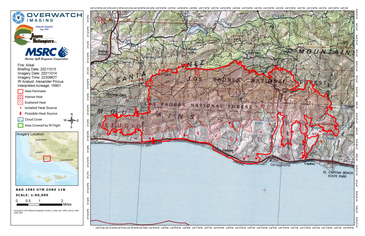
Friday's Infrared Map
Note: Map is 1,200 pixels wide.
Click here for Saturday's Updates: Santa Barbara County Alisal Fire Updates for Saturday, October 16, 2021
Note: Highway 101 has reopened in both directions from Goleta to Highway 1, reports CHP - Santa Barbara.
The railway parallel to Highway 101 has also reopened for travel in both directions and all services are expected to back to normal.
Alisal Fire Update for Friday, October 15, 2021
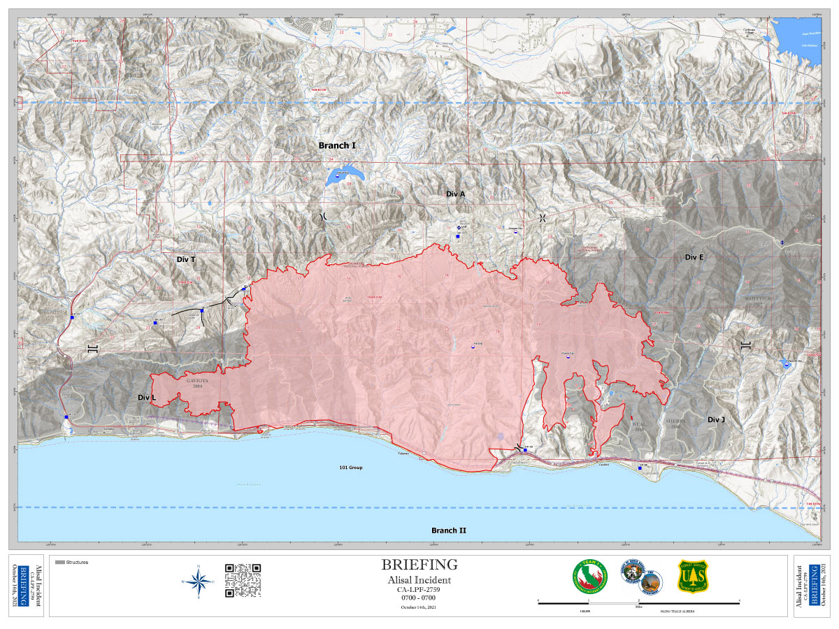
16,901 Acres
41% Containment
1,731 Total Personnel
Yesterday
Fire crews made significant progress resulting in the reopening of California Highway 101 and the Union Pacific Railroad. Both had been shut down as a result of the fire’s spread. Firefighters began to mop-up around much of the fire, including Camino Cielo, Refugio Canyon and along Hwy 101. Firefighters “mop-up” after the fire has been controlled by extinguishing or removing burning material near the control line. Crews secured the perimeter along Reagan Ranch and Refugio Canyon. Hot shot crews also began to cold trail areas along the old Sherpa Fire burn scars, which is a method of controlling a partly dead fire edge by carefully inspecting with the hand for heat to detect any fire. And along Hwy 101, crews removed hazard trees, while helicopters engaged the fire’s edge. The public is reminded to drive cautiously on Hwy 101 as crews continue to monitor the area. Last night, firefighters responded to isolated fire activity on the western most portion of the fire.
Today
Today’s priorities will be to secure the fire’s eastern edge along the old Sherpa Fire burn scar, address the western portion near the Cañada San Onofre, and ensure the fire holds where it has been contained. Crews will continue to use aviation assets as conditions allow.
Weather
Winds are the primary force behind fire growth. Expect winds to switch back and forth from a northerly to southerly direction throughout the day with gusts up to 20 mph. Wind switches, warm temperatures and decreasing humidity combined have the potential to increase fire activity. Strong down sloping winds will continue to impact fire behavior over the next several days.
Evacuations
Santa Barbara County’s evacuation orders remain in effect for Arroyo Hondo Canyon, Refugio Canyon, and the area between El Capitan Beach State Park and West Camino Cielo. Evacuation warnings are still in effect for the area east of El Capitan Beach State Park, west of Dos Pueblos Canyon Rd, and south of West Camino Cielo.
Basic Information
| Current as of | 10/15/2021, 6:44:17 AM |
| Incident Type | Wildfire |
| Cause | Undetermined |
| Date of Origin | Monday October 11th, 2021 approx. 02:15 PM |
| Location | 20 miles northwest of Santa Barbara within Refugio Canyon |
| Incident Commander | California Interagency Incident Management Team 1 (CIIMT 1) Jerry McGowan ICT1. |
| Incident Description | Wildfire |
| Coordinates | 34.517 latitude, -120.131 longitude |
Current Situation
| Total Personnel | 1,731 |
| Size | 16,901 Acres |
| Percent of Perimeter Contained | 41% |
| Estimated Containment Date | Monday October 25th, 2021 approx. 12:00 AM |
| Fuels Involved |
Chaparral (6 feet), short grass (1 foot) Hardwood Litter |
| Significant Events |
Fire remained active throughout the day in most divisions with active torching, flanking, and backing. The majority of growth was located on the western flank towards Gaviota. |
Outlook
| Planned Actions |
Establish anchor points with direct and indirect attack. Utilize fixed and rotor wing air assets, continue structure protection, and ensure mop up. |
| Projected Incident Activity |
12 hours: Some growth potential exists due to forecasted northwest to north winds over the fire area, in the evening to push the fire east of Refugio Canyon. Also, westward spread will continue midslope just upslope from Gaviota (dry fuels, fuel continuity and downslope winds). 24 hours: Fire growth potential exists due to forecasted northeast winds switching to West daytime, turning back Northeast over the fire area in the evening. Active section of line due to lack of containment and difficult terrain is to the West towards Gaviota and 101. Westward spread will continue just upslope of Gaviota (dry fuels, fuel continuity, and downslope winds). 48 hours: Fire growth potential exists due to forecasted morning northeast winds switching to West daytime, turning back Northeast over the fire area in the evening. Active section of line due to lack of containment and difficult terrain is to the West towards Gaviota and 101. Westward spread will continue midslope just upslope of Gaviota (dry fuels, fuel continuity and downslope winds). |
| Remarks |
CA Highway 101 and the Union Pacific Railroad and Amtrak line were opened at 1900. |
Current Weather
| Weather Concerns |
Seasonable temperatures prevailed across the area today ranging from the 60's near the coast to the lower to middle 70's inland. Relative humidity dropped into the 25-35% range. Northerly winds in the morning, shifted to a southerly and upvalley direction in the afternoon with gusts around 15 MPH. For tonight, dry conditions will persist with away from the beaches with poor overnight humidity recovery. Easterly winds will prevail at the higher elevations with gusts around 15 MPH. At lower elevations, typical downvalley winds are anticipated. For Friday and Saturday, warmer and dryer conditions are expected. Relative humidity will bottom out in the teens and single digits with poor overnight recoveries. At the ridges, winds will remain offshore, blowing from an easterly direction with typical diurnal winds at lower elevations. |
October 15, 2021 - Santa Barbara County Alisal Fire updates for Friday: 16,901 Acres with 41% Containment.
Overnight Infrared Flight Notes: Interpreted Size: 16,901 Interpreted Acres - Growth since last flight: 100 Acres
-Scattered heat exists in the northern half of the heat perimeter, but much of it is showing up as very faint signatures except for a few areas where the perimeter is growing.
-Heat source detected north of W Camino Cielo Rd and outside the NorthWestern edge of the perimeter.
Click here for: Santa Barbara County Alisal Fire Updates for Thursday, October 14, 2021
Friday's Briefing Map
Briefing Map Shows Divisions, Uncontrolled Fire Edge, Completed Dozer Lines.
Note: Map is 1,200 pixels wide