Click here for Sunday's Updates: Santa Barbara County Alisal Fire Updates for Sunday, October 17, 2021
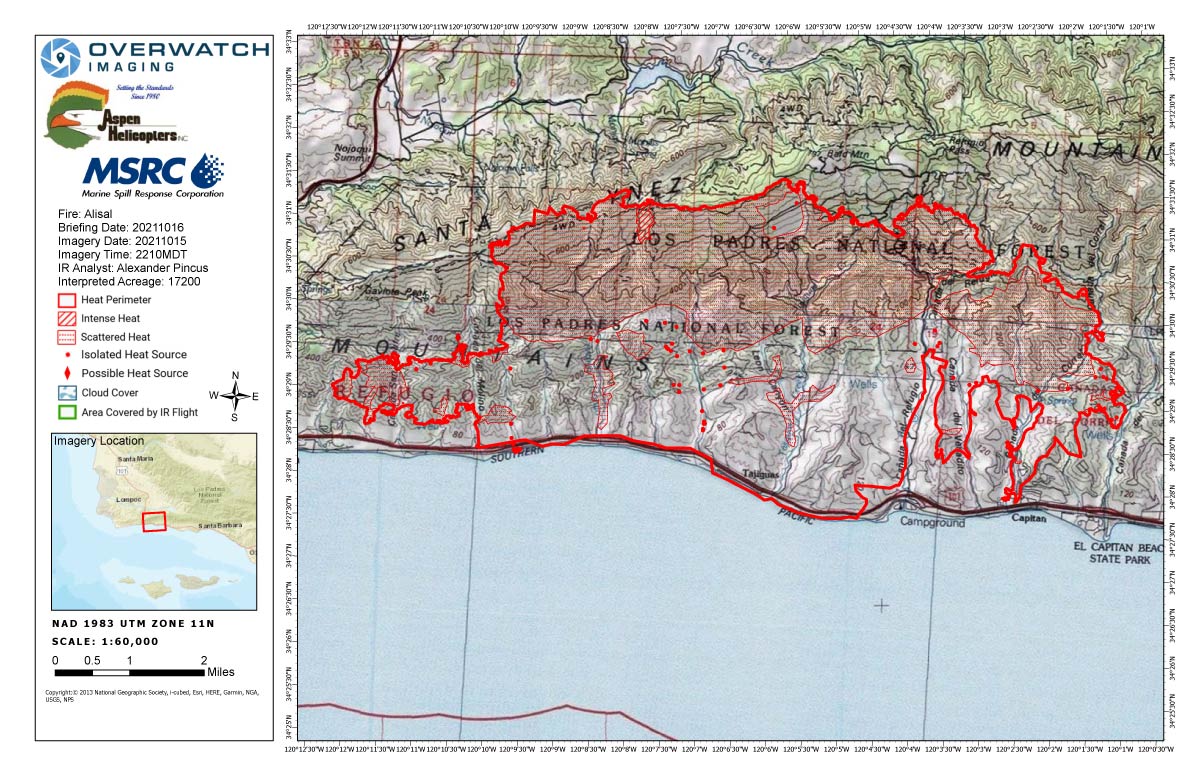
Saturday's Infrared Map
Note: Map is 1,200 pixels wide.
Click here for Sunday's Updates: Santa Barbara County Alisal Fire Updates for Sunday, October 17, 2021
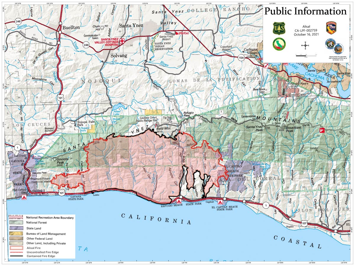
October 16, 2021 - Santa Barbara County Alisal Fire updates for Saturday: 17,200 Acres with 50% Containment.
Overnight Infrared Flight Notes: Interpreted Size: 17,200 Interpreted Acres - Growth since last flight: 299 Acres
-More interior cooling. Not much difference between scattered heat and isolated heat in some areas.
-Main growth to the west and a bit to the north.
Basic Information
| Current as of | 10/16/2021, 6:27:41 AM |
| Incident Type | Wildfire |
| Cause | Undetermined |
| Date of Origin | Monday October 11th, 2021 approx. 02:15 PM |
| Location | 20 miles northwest of Santa Barbara within Refugio Canyon |
| Incident Commander | California Interagency Incident Management Team 1 (CIIMT 1) Jerry McGowan ICT1. |
| Incident Description | Wildfire |
| Coordinates | 34.517 latitude, -120.131 longitude |
Current Situation
| Total Personnel | 1,747 |
| Size | 17,200 Acres |
| Percent of Perimeter Contained | 50% |
| Estimated Containment Date | Monday October 25th, 2021 approx. 12:00 AM |
| Fuels Involved |
Chaparral (6 feet), short grass (1 foot) Hardwood Litter |
| Significant Events |
Majority of fire growth in the morning was located in Division L on the western flank towards Gaviota. Another very active area throughout the day and into the evening was one spot near Drop Point 40 in Division T and another at the westside of Division A along the ridgetop. Unburned fuels and patches of fuels preheated by previous days underburning below canopy and reburning. Warmer temperatures, low humidity, and poor nighttime humidity recovery contributed to todays' activity marked increase in activity. |
Outlook
| Planned Actions |
Establish anchor points with direct and indirect attack. Utilize fixed and rotor wing air assets, continue structure protection, and ensure mop up. |
| Projected Incident Activity |
12 hours: Some growth potential exists due to forecasted east to southeast winds over the fire area, in the evening to push the fire west north of Gaviota toward Hwy 101. Posing a spotting threat to control line along the northern fire boundary of W. Camino Cielo Road. Also, westward spread will continue midslope just upslope of Gaviota (dry fuels, fuel continuity and downslope winds). 24 hours: Fire growth potential exists due to forecasted warmer conditions with upslope runs, south aspect has the greatest potential for unburned islands or pockets of fuel flaring up and torching or making a small run sending spots across northern control features. Active section of line due to lack of containment and difficult terrain is to the West towards Gaviota and 101. Westward spread will continue just upslope of Gaviota (dry fuels, fuel continuity, and downslope winds). 48 hours: Fire growth potential exists due to forecasted cooler southerly winds. Active section of line due to lack of containment and difficult terrain is to the West towards Gaviota and 101. Westward spread will continue midslope just upslope of Gaviota (dry fuels, fuel continuity and downslope winds). |
| Remarks |
With the decrease in fire activity along the CA Highway 101 corridor, a significant portion of type 1 engines may begin to demobed on 10/17. |
Current Weather
| Weather Concerns |
Very warm and dry conditions prevailed across the incident today. Afternoon temperatures climbed into the upper 70s and 80s while relative humidity dropped to the 11-15% range. At the ridges, weak northerly winds in the morning shifted to a southerly direction in the afternoon with gusts around 15 MPH. At lower elevations, upvalley winds, gusting to around 15 MPH, developed in the afternoon. For tonight, gusty northwest to north winds will develop this evening with gusts of 15-25 MPH likely. There is a possibility of even stronger gusts near the Gaviota Pass area. The northerly winds will diminish after midnight and shift to a northeasterly directions. Relative humidity recovery will be very poor tonight. Warm and dry conditions will continue through Saturday. On Sunday, a pattern change will occur as a dry cold front approaches the area. Cooler temperatures and higher relative humidity can be expected on Sunday. The dry cold front will pass over the incident Sunday night and Monday morning, bringing even cooler temperatures and higher relative humidity. However, the passage of the cold front will bring some strong northwest to north winds to the area on Monday with gusts of 25-35 MPH likely. |
Click here for: Santa Barbara County Alisal Fire Updates for Friday, October 15, 2021
Saturday's Public Information MapShows Uncontrolled Fire Edge
Note: Map is 1,200 pixels wide