Click here for Monday's Updates: Santa Barbara County Alisal Fire Updates for Monday, October 18, 2021
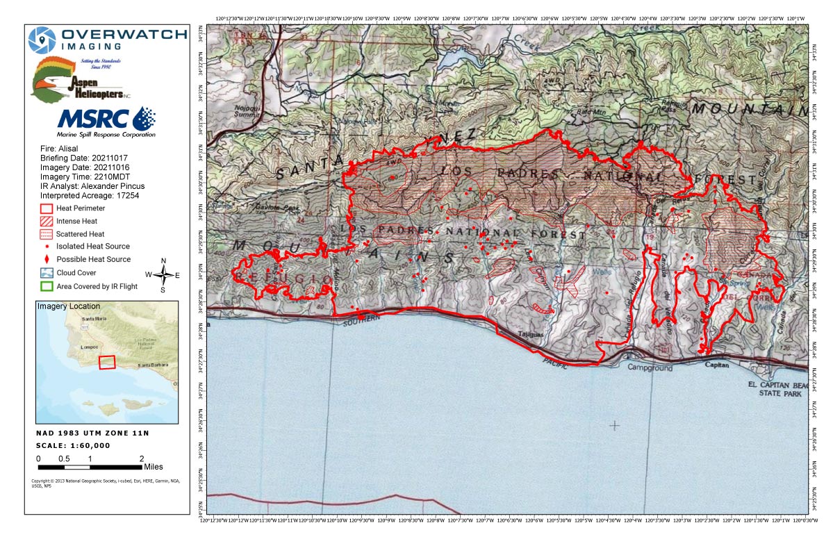
Sunday's Infrared Map
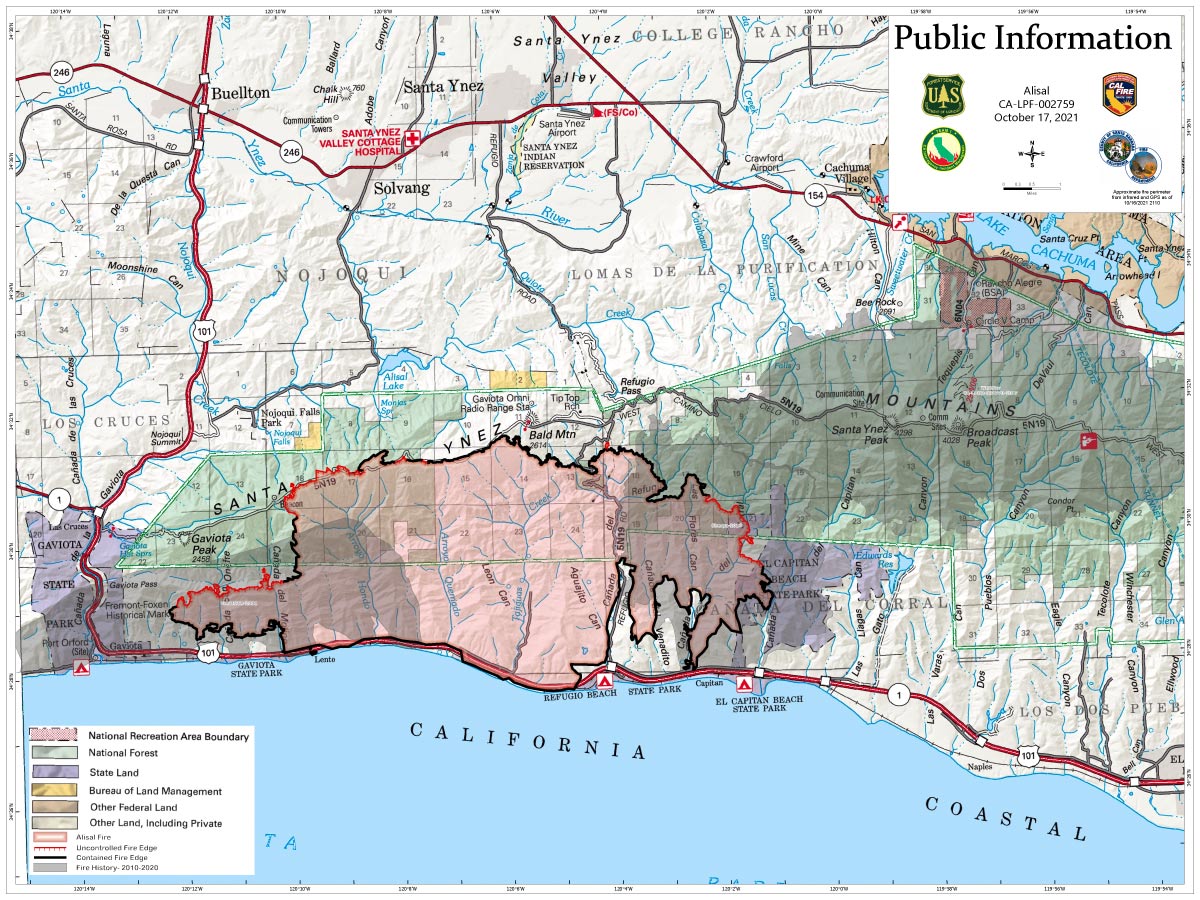
Note: Map is 1,200 pixels wide.
Click here for Monday's Updates: Santa Barbara County Alisal Fire Updates for Monday, October 18, 2021
Update 9: 25 A.M.
Alisal Fire Update for Sunday, October 17, 2021
17, 253 Acres
78% Containment
1,655 Total Personnel
Yesterday
Warm temperatures mixed with very dry and windy conditions resulted in an increase in isolated fire activity. A spot fire approximately an acre and a half popped up outside a retardant line on the northwestern corner. Firefighters immediately contained it with dozer and hand lines while aircraft doused it with water. Crews mopped up containment lines near Reagan Ranch. Young fuels left behind by the 2016 Sherpa Fire have lent themselves to steady progress to the east, where rugged terrain pose challenges to firefighters and their heavy equipment. Along California 101 — which reopened Oct. 14 — firefighters fortified containment and continued mop-up efforts. Motorists along Hwy 101 are encouraged to give firefighters and their equipment wide berth when passing. Additionally, on the northeastern corner, an area less than an acre slopped over the perimeter, but crews constructed handline and flanked hose around it.
Today
Few hot spots remain. Today’s main priority is to contain patches of heat remaining to the northwest edge of the fire. Crews will also focus on holding the rest of the fire’s footprint. Crews will continue to use aviation assets as conditions allow.
Weather
Onshore flow will strengthen across the area, bringing cooler temperatures and higher relative humidity. Southerly and upvalley winds will prevail through today with gusts around 20 mph. Later this evening and into tomorrow, a dry cold front will sweep across the area, delivering even cooler temperatures and higher humidity. It will, however, also bring strong northwest to north winds to the fire with gusts up to 25-35 mph.
Evacuations
The Evacuation Warning for the area west of Highway 101, including Gaviota Beach and Hollister Ranch properties, has been cancelled. Take caution when returning home as emergency personnel remain in the area. Stay alert to changing conditions.
October 17, 2021 - Santa Barbara County Alisal Fire updates for Sunday: 17,253 Acres with 78% Containment.
Overnight Infrared Flight Notes: Interpreted Size: 17,254 Interpreted Acres - Growth since last flight: 54 Acres
Almost no perimeter growth.
Cooling continues on the interior.
Lots of very faint heat signatures in scattered heat areas.
Basic Information
| Current as of | 10/17/2021, 6:24:59 AM |
| Incident Type | Wildfire |
| Cause | Undetermined |
| Date of Origin | Monday October 11th, 2021 approx. 02:15 PM |
| Location | 20 miles northwest of Santa Barbara within Refugio Canyon |
| Incident Commander | California Interagency Incident Management Team 1 (CIIMT 1) Jerry McGowan ICT1. |
| Incident Description | Wildfire |
| Coordinates | 34.517 latitude, -120.131 longitude |
Current Situation
| Total Personnel | 1,655 |
| Size | 17,253 Acres |
| Percent of Perimeter Contained | 78% |
| Estimated Containment Date | Monday October 25th, 2021 approx. 12:00 AM |
| Fuels Involved |
Chaparral (6 feet), short grass (1 foot) Hardwood Litter |
| Significant Events |
Another very active day along the ridgetop, where there is a few active spots. These areas have increased activity just like yesterday, between 1200-1400 significant increase in fire behavior and spotting across line to the north over W. Camino Cielo Road. Alignment of unburned pockets of fuel inside the line picking up with diurnal upslope winds, south aspect exposure, surface heating from direct solar radiation, very low humidities, and low fuel moistures (live & dead) have contributed to increased activity and spotting. Multiple spots today, one near DP-40 in Div-T, and couple new ones in Div-A near the westside of Div-A are along the ridgetop. These are in addition to the couple spots in approximately the same area yesterday, Warmer temperatures, low humidity, and poor nighttime humidity recovery contributed to todays' activity marked increase in activity. |
Outlook
| Planned Actions |
The overall strategy is to engage firefighters to minimize the fire size, eliminate the fire threat to CA Highway 101 (to open both north and south bound lanes), protect residence and infrastructure, historic and cultural resource threats in the area. The main constraint has been heavy winds that have limited safe access to suppress the fire and limited the use of aircraft to engage and support fire suppression. Firefighters have been able to engage along the West Camino Cielo on the north side of the fire. |
| Projected Incident Activity |
12 hours: Some growth potential exists due to forecasted southerly winds over the fire area, in the evening to push the fire north of West Camino Cielo Road. This is an area receptive to spotting threat to control line along the north boundary of the Alisal fire. 24 hours: Fire growth potential exists due to forecasted warmer conditions with upslope runs, south aspect has the greatest potential for unburned islands or pockets of fuel flaring up and torching or making a small run sending spots across northern control features. Active section of line due to lack of containment and difficult terrain is to the West towards Gaviota and 101. 48 hours: Fire growth potential exists due to forecasted gusty northwest to north winds with expected gusts 25-35 MPH likely in the windier spots. Active section of line due to lack of containment and difficult terrain is to the West towards Gaviota and 101. Westward spread will continue midslope just upslope of Gaviota (dry fuels, fuel continuity and downslope winds). |
| Remarks |
With the complexity of the incident and the threat to the CA Highway 101 corridor decreasing, resources may be released. Some areas of the fire are transitioning from suppression to repair. Resources that can be transitioned from suppression to repair will be utilized in those areas. Excess equipment will be reassigned or released. |
Current Weather
| Weather Concerns |
Very warm and dry conditions prevailed across the incident today. Afternoon temperatures climbed into the upper 70s and 80s while relative humidity dropped to the 7-13% range. Gusty southerly and upvalley winds developed by late morning with gusts around 20 MPH reported in the afternoon hours. For tonight, weak southerly winds will continue at the ridges with weak downslope and downvalley winds at lower elevations. Relative humidity recovery will be poor to moderate with best recovery at lower elevations near the coast. On Sunday, onshore flow will strengthen across the area, bringing cooler temperatures (10-15 degrees cooler than Saturday) and higher relative humidity. Southerly and upvalley winds will prevail through the day on Sunday with gusts around 20 MPH. Late Sunday night and Monday morning, a dry cold front will sweep across the area. This front will bring even cooler temperatures on Monday as well as higher relative humidity. However, it will also bring strong northwest to north winds to the fire with gusts 25-35 MPH likely throughout the day and evening on Monday. |
Click here for: Santa Barbara County Alisal Fire Updates for Saturday, October 16, 2021
Sunday's Public Information MapShows Uncontrolled Fire Edge
Note: Map is 1,200 pixels wide