


California and National Drought Summary for January 2, 2018
Summary
January 4, 2018 - During the 7-day period (ending Tuesday morning), bitterly cold, mostly dry weather prevailed across the nation. However, light to moderate showers were observed along the central Gulf Coast, while moderate to heavy rain and mountain snow were reported in the nation’s northwestern quadrant. At the end of the period, a moderate to deep snowpack extended from the interior Northwest across the northern Plains into New England. The overall trend toward drought intensification persisted from the Four Corners to the southern Plains and south-central U.S., while modest reductions in drought intensity and coverage were made in northern Montana.Northeast
Dry, bitter cold conditions prevailed across New England, where temperatures averaged more than 20°F below normal. There were no changes made to the New England drought depiction, with all eyes on the approaching potentially historic winter storm as of Wednesday, January 3. Farther south, Moderate Drought (D1) was expanded from northeastern Pennsylvania into central Maryland; 90-day precipitation in these locales has totaled less than 70 percent of normal, and groundwater levels continued to drop (25th percentile or lower in many reporting locations).Southeast
Chilly, mostly dry weather prevailed over the Southeast, though warmer-than-normal conditions (up to 4°F above normal) lingered in southern Florida. A boundary separating the two air masses was the focus for lingering light showers (less than an inch) from southern Alabama to the southeast Georgia Coast. The rain was not sufficient to prevent the expansion of Moderate Drought (D1) in southern Alabama and the western Florida panhandle, with 60-day rainfall averaging a meager 20 to 30 percent of normal. Likewise, Abnormal Dryness (D0) and D1 were expanded to varying degrees from central and northern Alabama into the Carolinas and northern Virginia. Rainfall over the past 60 days averaged less than 50 percent of normal from central Alabama into central and northern Virginia, while 90-day totals have totaled 30 to 60 percent of normal from central North Carolina up to the Potomac River Basin. Streamflows are particularly low (5th percentile or lower) from central North Carolina northward.South
Despite recent rain, the recent trend toward drought intensification and expansion resumed. In particular, additional assessments from local experts as well as updated data and indices indicated drought conditions were slow to relinquish their grip across the central and northern Delta. Moderate to Severe Drought (D1 and D2) were reintroduced to locales in Louisiana, Mississippi, and Arkansas where 90-day rainfall was 60 percent of normal or less and subsequent streamflows — which exhibited short-term recovery after late-December rain — resumed a sharp downward trend. Soil moisture remained limited in northern Arkansas and from central Louisiana into Mississippi. Farther east, Abnormal Dryness (D0) was introduced in the southeastern and northeastern corners of Tennessee, where 60-day precipitation has tallied less than 50 percent of normal.Midwest
Bitter cold weather prevailed with a moderate to deep snowpack covering all but southern portions of the region. Changes were limited to a small increase of Moderate Drought (D1) in parts of Missouri, where 90-day precipitation was locally less than half of normal. Impacts are minor and generally confined to low groundwater levels (locally below the 10th percentile).High Plains
Extreme cold gripped the region, accompanied by much-needed moderate to heavy snowfall. Temperatures for the period averaged 25 to 35°F below normal from eastern Montana into the Dakotas and northern Nebraska. There were no changes made to the drought depiction in central and eastern portions of the region, while reductions in Abnormal Dryness, Moderate Drought, and Severe Drought (D0-D2) were made in northwestern Montana to account for the favorable start to the Water Year and the easing of long-term moisture deficits; 12-month precipitation climbed to near-normal levels in western Montana, but was still less than 50 percent of normal in the lingering Extreme Drought (D3) areas.West
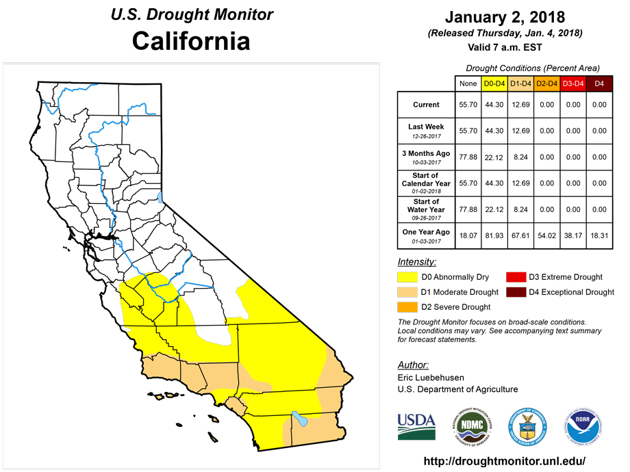
Drought intensified in the Four Corners, while heavy snow brought welcomed drought relief to northeastern portions of the region. Across Montana, Abnormal Dryness to Severe Drought were trimmed along the Canadian border to account for the favorable start to the Water Year and subsequent easing of long-term moisture deficits; 12-month precipitation climbed to near-normal levels in western Montana, but was still less than 50 percent of normal in the lingering Extreme Drought (D3) areas. While no changes were made to the Pacific Coast States, the poor start to the current Water Year was raising concerns over drought resumption from the Cascades southward into central and southern California. In particular, 90-day precipitation has averaged less than 40 percent of normal from central Oregon southward into central California, and less than 10 percent from the southern San Joaquin Valley into southern portions of Nevada and Arizona. Severe Drought (D2) was expanded over large portions of the Four Corners region, coincident with much-below-normal precipitation totals over the past 6 months (30-65 percent of normal). Farther east, Moderate Drought (D1) expanded across northern portions of New Mexico and environs, where short-term dryness (10-40 percent of normal over the past 90 days) was most pronounced.Alaska, Hawaii, and Puerto Rico
There were no changes to the drought depiction in Hawaii during the period, though the benefits of moderate to heavy rain on Oahu (1-6 inches, locally more) will need to be assessed over the upcoming weeks. Alaska and Puerto Rico remained free of Abnormal Dryness or drought.Looking Ahead
A rapidly-intensifying storm system near the Atlantic Seaboard will produce wind-driven snow from parts of the Mid-Atlantic into the Northeast. Substantial snow- and wind-related impacts are expected in New England, as well as coastal cities such as Savannah, Georgia, and Charleston, South Carolina. In the storm’s wake, late-week temperatures will again plunge across the Midwest and Northwest. However, temperatures will rebound to above-normal levels by Sunday in all areas west of the Mississippi River. In the middle and lower Mississippi Valley and environs, some rain or freezing rain could precede the warmer weather. Elsewhere, periods of rain and snow will affect northern California and the Northwest, while dry weather prevails across the central and southern Plains. The NWS 6- to 10-day outlook for January 9 – 13 calls for above-normal precipitation across much of the nation, with drier-than-normal weather confined to the nation’s southern tier save for the Southwest. Colder-than-conditions will linger in the upper Midwest, while near- to-above-normal temperatures prevail elsewhere, with the greatest likelihood of abnormal warmth from the Rockies to the Pacific Coast.Author(s):
Eric Luebehusen, U.S. Department of Agriculture
Dryness Categories
D0 Abnormally Dry—used for areas showing dryness but not yet in drought, or for areas recovering from drought.Drought Intensity Categories
D1 Moderate DroughtD2 Severe DroughtD3 Extreme DroughtD4 Exceptional DroughtDrought or Dryness Types
S Short-Term, typically less than 6 months (e.g. agricultural, grasslands)L Long-Term, typically greater than 6 months (e.g. hydrologic, ecologic)Source: National Drought Mitigation Center

