


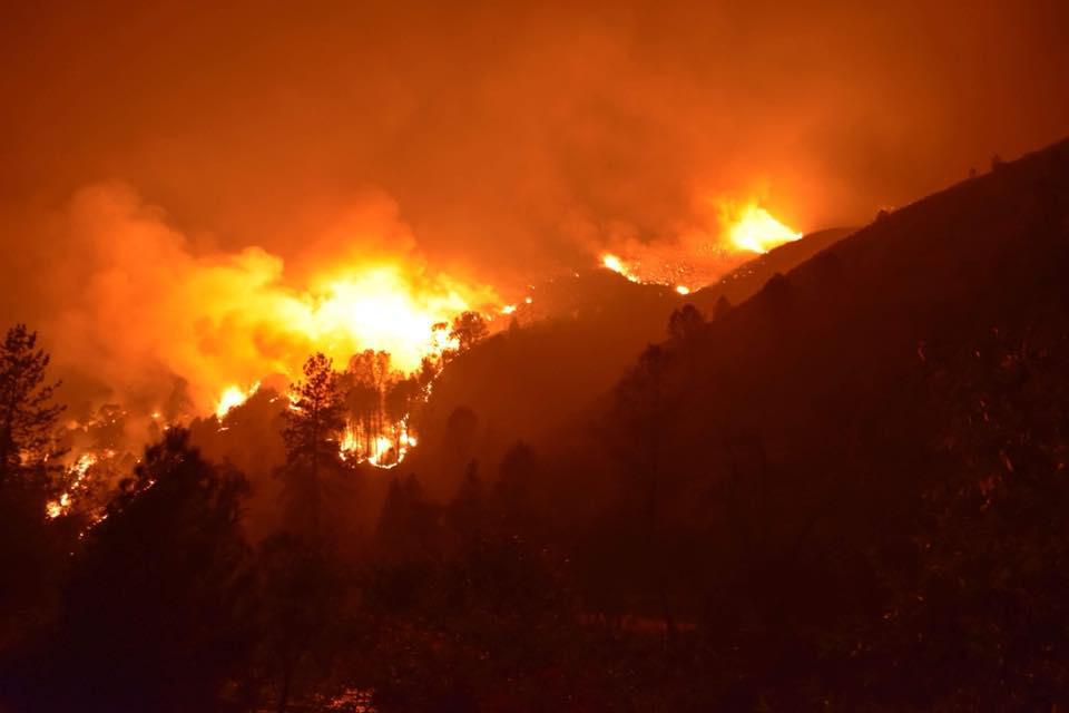
Ferguson Fire Photo credit: Blake-Scott - NPS
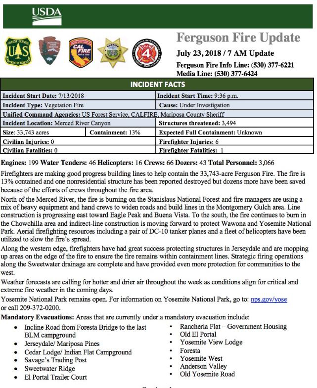
33,743 acres with 13% containment.
Update: 7:00A.M.
Engines: 199 Water Tenders: 46 Helicopters: 16 Crews: 66 Dozers: 43 Total Personnel: 3,066
Firefighters are making good progress building lines to help contain the 33,743-acre Ferguson Fire. The fire is 13% contained and one nonresidential structure has been reported destroyed but dozens more have been saved because of the efforts of crews throughout the fire area.
North of the Merced River, the fire is burning on the Stanislaus National Forest and fire managers are using a mix of heavy equipment and hand crews to widen roads and build lines in the Montgomery Gulch area. Line construction is progressing east toward Eagle Peak and Buena Vista. To the south, the fire continues to burn in the Chowchilla area and indirect-line construction is moving forward to protect Wawona and Yosemite National Park. Aerial firefighting resources including a pair of DC-10 tanker planes and a fleet of helicopters have been utilized to slow the fire’s spread.
Along the western edge, firefighters have had great success protecting structures in Jerseydale and are mopping up areas on the edge of the fire to ensure the fire remains within containment lines. Strategic firing operations along the Sweetwater drainage are complete and have provided even more protection for communities to the west.
Weather forecasts are calling for hotter and drier air throughout the week as conditions align for critical and extreme fire weather in the coming days.
Yosemite National Park remains open. For information on Yosemite National Park, go to: nps.gov/yose
or call 209-372-0200.
Mandatory Evacuations: Areas that are currently under a mandatory evacuation include:
· Incline Road from Foresta Bridge to the last BLM campground
· Jerseydale/ Mariposa Pines
· Cedar Lodge/ Indian Flat Campground
· Savage’s Trading Post
· Sweetwater Ridge
· El Portal Trailer Court
• Rancheria Flat – Government Housing
• Old El Portal
• Yosemite View Lodge
• Foresta
• Yosemite West
• Anderson Valley
• Old Yosemite Road
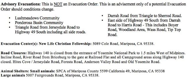
Advisory Evacuations: This is NOT an Evacuation Order. This is an advisement only of a potential Evacuation Order should conditions change.
• Lushmeadows Community
• Ponderosa Basin Community
• Triangle Road from Jerseydale Road to Highway 49 South including all side roads.
• Darrah Road from Triangle to Sherrod Road.
• East side of Highway 49 South from Darrah Road to Harris Road - This includes Boyer Road, Woodland Area, Wass Road, Tip Top Road.
Evacuation Center(s): New Life Christian Fellowship: 5089 Cole Road, Mariposa, CA 95338.
Road Closures: Highway 140 is closed from the entrance of Yosemite National Park to 1.5 miles West of Midpines. Incline Road, River Road from Briceburg to the gate at Railroad Flat and all Campground areas along Highway 140 closed. Hites Cove / Jerseydale Road, Foresta Road, Anderson Valley Road and Old Yosemite Road.
Animal Shelters: Small animals: SPCA of Mariposa County 5599 California 49, Mariposa, CA 95338 Large animals: 5007 Fairgrounds Road, Mariposa, CA 95338.
July 23, 2018 - Awahanee, CA. - The Ferguson Fire started July 13 on the Sierra National Forest and is managed under unified command between the United States Forest Service, California Interagency Incident Management Team 4, CALFIRE and the Mariposa County Sheriff’s Office. Much of the fire is burning in steep, rugged terrain with little to no access roads. Mandatory and advisory evacuations are in place in several areas but no homes have been damaged or destroyed.
The Ferguson Fire is burning in very rough terrain with high firefighter exposure due to very hot conditions and limited access requiring heavy rotor wing support. The fire grew more than 2,500 acres throughout the day and into the night hours Friday. Prior to the Rough Fire, this river canyon held the record for the largest fire on the Sierra NF which burned in 1924.
Secretary of the Interior, Ryan Zinke visited the Ferguson Fire in Mariposa County Saturday....
Yosemite National Park remains open, nps.gov/yose or call 209-372-0200
The fire is 33,743 acres with 13% containment. 3,066 personnel are currently engaged on the fire which includes 199 engines, 46 water tenders, 16 helicopters, 66 crews, and 43 dozers. There has been 1 fatality and 6 injuries to date.
Road Closures:
Hwy 140 is closed from 1.9 miles east of Midpines to the Cedar Lodge area MOTORISTS ARE ADVISED TO USE AN ALTERNATE ROUTE
Mandatory Evacuations:
These area are currently under a mandatory evacuation include:
El Portal Trailer Court
Incline Rd from Clearing House to the last BLM campground
Jerseydale/ Mariposa Pines
Cedar Lodge/ Indian Flat Campground
Savage’s Trading Post
Sweetwater Ridge
El Portal Trailer Court
Rancheria Flat - Government Housing
Old El Portal
Yosemite View Lodge
Foresta
Yosemite West
Old Yosemite Road
Evacuation Advisory:
This is NOT an Evacuation Order. This is an advisement only of a potential Evacuation Order should conditions change.
• Lushmeadows Community
• Ponderosa Basin Community
• Triangle Rd from Jerseydale Rd to Hwy 49 South including all side roads.
• Darrah Rd from Triangle to Sherrod Rd
• East side of Hwy 49S from Darrah Rd to Harris Rd- This includes Boyer Rd, Woodland Area, Wass Rd, Tip Top Rd
Evacuation Center:
New Life Christian Fellowship, 5089 Cole Rd, Mariposa, CA 95338
Mariposa Sheriff’s Office Emergency Alert System: To sign up for the go to: https://local.nixle.com/register/
Animal Shelters: Small animals, SPCA, 5599 California 49, Mariposa, CA 95338 and large animals, Mariposa County Fairgrounds, 5007Fairgrounds Road, Mariposa, CA 95338
Donations: When you want to help
Incident Command Post (ICP): The incident command post for the Ferguson Fire is located at the Awahanee Regional Park. An additional camp has been established at Badger Pass.
Cooperators: California Highway Patrol, CalTrans, Pacific Gas and Electric, California Conservation Corps, Mariposa County Public Works and the American Red Cross
From lakeside camping and picnicking to wilderness solitude, the Sierra National Forest is destination recreation. With intensely used and highly developed lakes and the world famous Ansel Adams and John Muir Wildernesses, the Sierra provides the extreme ends of recreation settings. These sharp contrasts provide destinations for visitors to escape from the heat and routine urban life, connect with nature, family and friends. Given the proximity to large, diverse and growing urban areas the Forest has a responsibility to provide heritage and conservation education to sustain this incredible landscape for future generations.
The Stanislaus National Forest contains many special places, including the entire Emigrant Wilderness as well as portions of the Carson-Iceberg and Mokelumne Wilderness Areas. Together, these three Wilderness Areas make up almost one quarter of the Stanislaus National Forest and contain some of the Forest's most spectacular scenery.
First protected in 1864, Yosemite National Park is best known for its waterfalls, but within its nearly 1,200 square miles, you can find deep valleys, grand meadows, ancient giant sequoias, a vast wilderness area, and much more.

