


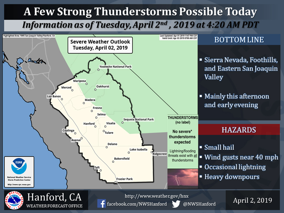
Thunderstorms are possible in Mariposa, Oakhurst, and Yosemite National Park
April 2, 2019 - The National Weather Service Hanford Office reports a few thunderstorms are possible this afternoon and evening.
Small hail, gusty winds are possible. In addition to dangerous cloud to ground lightning strikes, any thunderstorm can produce intense rainfall rates, leading to localized flooding.
Area Forecast Discussion
  National Weather Service San Joaquin Valley - Hanford CA
  345 AM PDT Tue Apr 2 2019

  .SYNOPSIS...
  A storm system will bring scattered showers today, mostly in
  the Sierra from Yosemite to Kings Canyon. There is also a slight
  chance of thunderstorms north of Kern County this afternoon.
  Winds will become gusty in the Kern County Mountains and Desert
  this afternoon and evening. Dry conditions will prevail Wednesday
  then a chance for some light showers Thursday followed by a better
  chance for more significant precipitation Friday and Saturday.

  &&

  .DISCUSSION...
  Satellite water vapor imagery shows the upper low spinning just
  off the Oregon coast this morning. Regional radars are detecting
  just scattered weak echoes across central California at this time
  while some moderate showers are observed over northern California.
  Precipitation amounts have been very light thus far only a few
  hundredths to a couple tenths of an inch, mainly over the Sierra.
  Temperatures are generally running a little warmer than this time
  last night with some areas around 10 degrees higher.

  Scattered showers will continue to develop this morning and will
  increase in coverage this afternoon as additional s/wv energy
  dives down towards the central CA coast. The Sierra Nevada will
  see the bulk of the showers due to orographic enhancement. There
  is a slight chance for afternoon thunderstorms as daytime heating
  maximizes instability and a ~110kt upper jet moves overhead. The
  thunder threat will be north of Kern County and mainly across the
  eastern side of the San Joaquin Valley and into the Sierra Nevada.
  Storms will be capable of producing briefly heavy rainfall, gusty
  winds, small hail and possibly funnel clouds. QPF is highest over
  the Sierra in Yosemite NP where around 0.75" is possible. Amounts
  taper to the south with around 0.25" forecast in the Tulare County
  Mountains. The Sierra Foothills can expect 0.25"-0.5" while the
  San Joaquin Valley and Kern County Mountains may only get a few
  hundredths to a tenth of an inch. But if any thunderstorms were to
  develop, they could put down more than a quarter inch of rain in
  a very short time. Snow levels will be above 7000 feet for the
  bulk of the event, only lowering to around 6000 feet Tuesday night
  as the system winds down. Snow amounts of 3-6 inches are forecast
  with local amounts of 9 inches possible around Yosemite NP. Winds
  will increase this afternoon as the onshore surface flow ramps up.
  Wind gusts to around 40 mph will be possible through and below the
  Kern County Mountain passes into the Desert this aftn and evening.
  Temperatures will be cooler today with highs falling back to near
  normal for early April.

  The trough quickly shifts east to over the Four Corners region on
  Wednesday as short wave ridging moves over California for a return
  to dry weather. This will be a brief break as another Pacific low
  pressure system approaches the coast on Thursday. The focus for
  this event will be farther north with QPF of only a few hundredths
  to a tenth of an inch, mainly from Fresno County northward. But
  yet another system is forecast to impact the region by the end of
  the week. There remains a fair amount of uncertainty regarding the
  track and therefore where and how much precipitation. The models
  have generally been trending farther north as it moves inland from
  Friday into Saturday.
Source: NWS

