


Mariposa Projected High Temps for Tuesday 81 Degrees, 84 Degrees for Wednesday and 86 Degrees for Thursday
Oakhurst Projected High Temps for Tuesday 82 Degrees, 85 Degrees for Wednesday and 87 Degrees for Thursday
Yosemite Valley Projected High Temps for Tuesday 72 Degrees, 74 Degrees for Wednesday and 75 Degrees for Thursday
April 23, 2019 - The National Weather Service Hanford Office reports maximum temperatures this afternoon will be ten to fifteen degrees above normal for this time of year.
High temperatures Wednesday afternoon will be around five degrees warmer than Tuesday afternoon.
Maximum temperatures Wednesday afternoon will be fifteen to twenty degrees above normal for this time of year.
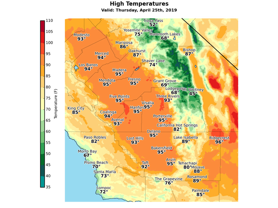
Here are projected maximum temperatures Thursday afternoon throughout Central California.
High temperatures Thursday afternoon will be fifteen to twenty degrees above normal for this time of year.
The daily record for maximum temperature ever measured in Bakersfield on April 25th is 97 degrees, set in 1946.
Temperature records at Bakersfield date back to 1889.
Area Forecast Discussion
  National Weather Service San Joaquin Valley - Hanford CA
  126 AM PDT Tue Apr 23 2019

  .SYNOPSIS...A warming trend will continue across the forecast
  area for the next few days as an Eastern Pacific ridge of high
  pressure builds, which will also lead to dry weather. An upper
  level low will reintroduce precipitation chances into the forecast
  this weekend, as well as cooler temperatures.


  .DISCUSSION...High temperatures across the SJ Valley today will
  increase by several degrees compared to yesterday, with several
  areas progged to reach 90 degrees by mid afternoon. This is due to
  a ridge of high pressure aloft that is drifting towards
  California from the Eastern Pacific. High temperatures will
  continue to trend up on Wednesday, as highs across the valley
  are expected to reach into the mid 90s. This time of the year,
  high temperatures on average are only in the 75-80 degree range,
  so highs in the mid 90s are 15-20 degrees above average. This heat
  will extend into Thursday and Friday. With highs expected to
  reach 95 degrees this week, we are reminding people to stay
  hydrated if they are outdoors for an extended period of time.
  Along with this rapid increase in temperatures will be an increase
  in snow melt in the mountains. An increase in snowmelt can make
  rivers levels rise with swift currents, and the water within
  rivers will be very cold. The combination of a swift current with
  very cold water can result in dangerous to deadly conditions for
  those planning to enter area rivers to get relief from the heat.

  Into this weekend, high temperatures will moderate on Saturday
  into the high 80s, as a low pressure system makes its way towards
  the California coastline. By Sunday, high temperatures should
  fall into the low to mid 80s, and light precipitation will be
  possible in the forecast area, including the mountains. Cooler air
  will follow this disturbance into early next week, with coarser-
  range models showing highs in the valley in the low 80s.
Source: NWS
