


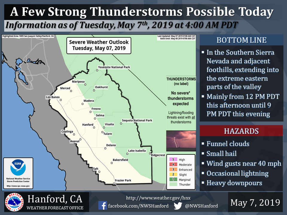
May 7, 2019 - The National Weather Service Hanford Office reports a few strong thunderstorms are possible in the Southern Sierra Nevada and adjacent foothills, extending into the extreme eastern portions of the San Joaquin Valley.
Funnel clouds, small hail, and wind gusts near 40 miles per hour are some of the hazards associated with strong thunderstorms.
In addition to dangerous cloud to ground lightning strikes, any thunderstorm can produce intense rainfall rates, leading to very localized flooding.
  Area Forecast Discussion
  National Weather Service San Joaquin Valley - Hanford CA
  335 AM PDT Tue May 7 2019

  .SYNOPSIS...
  A low pressure system over Southern California will provide
  cooler temperatures and unsettled weather over the Southern
  Sierra Nevada and adjacent foothills today through Wednesday. The
  greatest potential for rain this week in the San Joaquin Valley
  looks to be Thursday afternoon through Friday afternoon.

  &&

  .DISCUSSION...
  The upper low that has influenced the weather over the region
  continues to shift slowly southeastward today. In its wake,
  clouds and a few thunderstorms invaded Central California on
  Monday. Yet, due to the weak lift generated from a distant
  disturbance, storm activity was confined to the Sierra Nevada.
  However, the cloud cover did manage to keep temperatures on the
  cooler side as the San Joaquin Valley struggled to reach the 80
  degree-F mark. In addition, surface pressure gradients from KSFO
  to KLAS supported strong winds under the change in temperature.
  Yet, now that the cool air has overspread the region, pressure
  gradients have relaxed as winds continue to diminish. The wind
  advisory from Monday will be allow to expire this morning. While
  the upper continues to slow move into the Desert Southwest today,
  another round of mountain convection may bee seen as the
  environment is still primed with the needed ingredients for
  afternoon thunderstorms.

  Short range models progging the upper low over Southwestern
  Arizona this morning and shifting it toward the AZ/NM state line
  by the afternoon hours. During this time, a very weak piece of
  energy will cross Central California. Even with the weak lift from
  this piece of energy enough instability and moisture will exist
  over the region to support the generation of mountain convection.
  Therefore, will follow the Storm Prediction Center Guidance and
  place the Mountains and Foothills under the treat of convection
  while debris clouds float out into the valley locations. No
  significant precipitation is therefore expected over the valley as
  down-slope flow from an easterly direction dry out the lower
  atmosphere. And, just like Monday, the atmosphere will stabilize
  this evening and allow for some clearing overnight.

  Toward the middle of the week, models show the upper low merging
  back into the main flow as the West Coast remains in the cyclonic
  flow pattern. While an almost meridional flow pattern develops
  over the west, weak pieces of energy will continue to rotate
  around the cyclonic flow to generate additional convective events
  over the Sierra Nevada on Tuesday and possibly Wednesday. Later in
  the week, models still attempting to form a closed low that drops
  toward California from the Inter-mountain West. The current
  trajectory has changed little during the last few days and its
  cuts through Yosemite. While confidence is growing on the
  development of the upper low, high uncertainty exist on the time
  of when the low will cross the region. Will favor the faster
  timing of the GFS/Canadian and NOGAPS models and expect widespread
  precipitation by Thursday night. All models place the upper low
  offshore by the start of the weekend and begin drying out the
  region. While mountain convection may continue into the weekend,
  the remaining parts of the region will see dry and cool conditions
  going into the middle of May.
Source: NWS
