


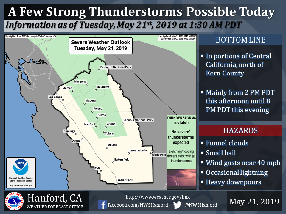
Thunderstorms Possible in Mariposa County, Oakhurst and Yosemite National Park Today
May 21, 2019 - The National Weather Service Hanford Office reports a few strong thunderstorms are possible in portions of the San Joaquin Valley, north of Kern County, and in parts of the Southern Sierra Nevada and adjacent foothills this afternoon and this evening.
Funnel clouds, small hail, and wind gusts near 40 miles per hour are some of the hazards associated with strong thunderstorms.
In addition to dangerous cloud to ground lightning strikes, any thunderstorm can produce intense rainfall rates, leading to localized flooding.
  Area Forecast Discussion
  National Weather Service San Joaquin Valley - Hanford CA
  412 AM PDT Tue May 21 2019

  .SYNOPSIS...An unsettled and cooler than normal weather pattern
  will persist over the central California interior through
  Memorial Day weekend.

  &&

  .DISCUSSION...Our reprieve from wet weather, as short-lived
  as it`s been, is about ready to come to an end. As of this
  writing another cold front is approaching from the north.
  The front will move southward through the central California
  interior this morning accompanied by some showers in many
  locations. In its wake, winds will become gusty this afternoon
  and evening in the San Joaquin Valley and in the Kern county
  mountains and desert. A wind advisory is in effect for the
  Kern county mountains and desert for this afternoon and
  evening. In the normally windy locations below the passes,
  winds could gust to 60 mph or higher later today.

  Aside from the wind, the atmosphere will become unstable this
  afternoon as another cold core low now over the Pacific
  Northwest settles southward into California. Unfortunately
  that means there is a renewed threat of isolated thunderstorms
  with hail, briefly heavy rain and gusty winds over our CWA
  this afternoon into early this evening. Showers associated with
  this storm system will be most numerous over the eastern third
  of the San Joaquin Valley as well as the foothills and higher
  elevations of the Sierra. This storm system appears to be limited
  on moisture, so the amount of precipitation it brings into the
  central California interior will be considerably less than the
  storm system that moved through here last weekend. Nonetheless,
  it`s going to bring a return of wintry weather to elevations
  above 5500 feet during the next 24 hours. Snow accumulations
  from this storm will range from just an inch or two in the Kern
  county mountains, up to 5 inches in the Tulare county mountains
  to as much as 8 to 12 inches over the highest elevations of
  Yosemite National Park. Hikers and campers over the high Sierra
  should be prepared for snow and unseasonably cold temperatures
  today and tonight. Even in the lower elevations such as the San
  Joaquin Valley, high temperatures today will remain below 70
  degrees. That`s a good 15 degrees below normal for this time of
  year.

  Otherwise, the storm will bring a scattering of showers to the
  district tonight as the center of this low pressure system moves
  directly over central California. Although this storm system
  slowly exits into the southeastern part of the state Wednesday,
  showers will probably linger over the mountains and desert through
  at least Wednesday evening. Keep in mind that this storm will not
  be in any hurry to move very far away from us later this week.
  A building ridge of high pressure over the southeastern part of
  the country could force this low pressure system to retrograde
  back into California later in the week which in turn could bring
  showers back into much of the central California interior
  Thursday, especially over the mountains and desert.

  If we get another respite from wet weather this week, it might be
  on Friday. The models forecast a dry northwest flow aloft over
  central California by then, much like the pattern we were in
  yesterday.  It`s now looking like Memorial Day weekend could trend
  cooler and unsettled again as yet another Gulf of Alaska low tracks
  southward down the California coast. If so, showers (and possibly
  thunderstorms) will become a daily part of our weather pattern
  Saturday through Memorial Day, especially over the mountains.
  Otherwise, temperatures during the next 7 days will average cooler
  than normal. Friday and next Tuesday look as if they`ll be our
  warmest days with thermometer readings possibly topping the 80
  degree mark in the San Joaquin Valley, but that`s still a good
  4 to 7 degrees below normal.  If it`s any consolation, high
  temperatures in the San Joaquin Valley could easily be over 100
  degrees this time of year.
Source: NWS
