


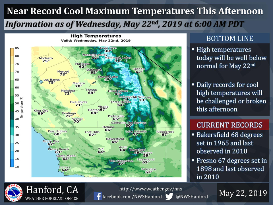
Projected high temperature for Mariposa: 62
Projected high temperature for Oakhurst: 62
Projected high temperature for Yosemite Valley: 52
May 22, 2019 - The National Weather Service Hanford Office reports high temperatures this afternoon will be fifteen to twenty degrees below normal for this time of year.
The daily record for coolest high temperature ever measured in Bakersfield on May 22nd will likely be set today.
Temperature records at Bakersfield date back to 1889. Temperature records at Fresno date back to 1887.
  Area Forecast Discussion
  National Weather Service San Joaquin Valley - Hanford CA
  246 AM PDT Wed May 22 2019

  .SYNOPSIS...
  Temperatures this afternoon will be near daily record values for
  coolest high temperatures ever measured on May 22nd. Temperatures
  will gradually moderate into the weekend, but will remain below
  normal for this time of year. The majority of precipitation this
  week should be confined to the Southern Sierra Nevada. A weekend
  storm system may be responsible for more widespread precipitation,
  beginning Saturday.

  &&

  .DISCUSSION...
  West to northwest wind gusts near 50 mph are currently being
  measured at Mojave Airport. These wind gusts should gradually
  subside this morning. The Wind Advisory for the Kern County
  mountains and desert may need to be extended past 4 AM PDT.
  Meanwhile, an area of low pressure aloft will meander around
  Southern California today. High temperatures this afternoon will
  be fifteen to twenty degrees below normal for this time of year.
  The daily record for coolest maximum temperature ever measured in
  Bakersfield on May 22nd will likely be set today. The current
  record is 68 degrees, initially established in 1965 and most
  recently observed in 2010. Temperature records at Bakersfield date
  back to 1889. Valley rain showers and mountain snow showers are
  possible throughout Central California this morning. Precipitation
  should be confined to the Southern Sierra Nevada and adjacent
  foothills, as well as the Kern County mountains and desert this
  afternoon into this evening.

  The aforementioned upper-level area of low pressure will move to
  the northeast tonight through Friday. This will allow temperatures
  to gradually moderate. Be that as it may, a trough of low
  pressure aloft will remain over Southern California tonight
  through Friday. This upper-level trough of low pressure will
  provide enough atmospheric instability for the possibility of snow
  showers in the Southern Sierra Nevada and rain showers in the
  Southern Sierra Nevada foothills tonight through Thursday evening,
  as well as Friday afternoon and Friday evening.

  An area of low pressure aloft near the coast of the Pacific
  Northwest should dive southward Friday night. Although the exact
  track of this atmospheric disturbance is still in question at this
  time, it could move southward near the coast of California
  Saturday through Sunday. A Winter Storm Watch may be required for
  the Southern Sierra Nevada this weekend, starting Saturday. The
  upper-level area of low pressure may move inland over Southern
  California Sunday night. This area of low pressure aloft should
  rapidly progress to the northeast over the Great Plains Monday,
  where it may stall Monday night and Tuesday.
Source: NWS

