


California and National Drought Summary for October 1, 2019
Summary
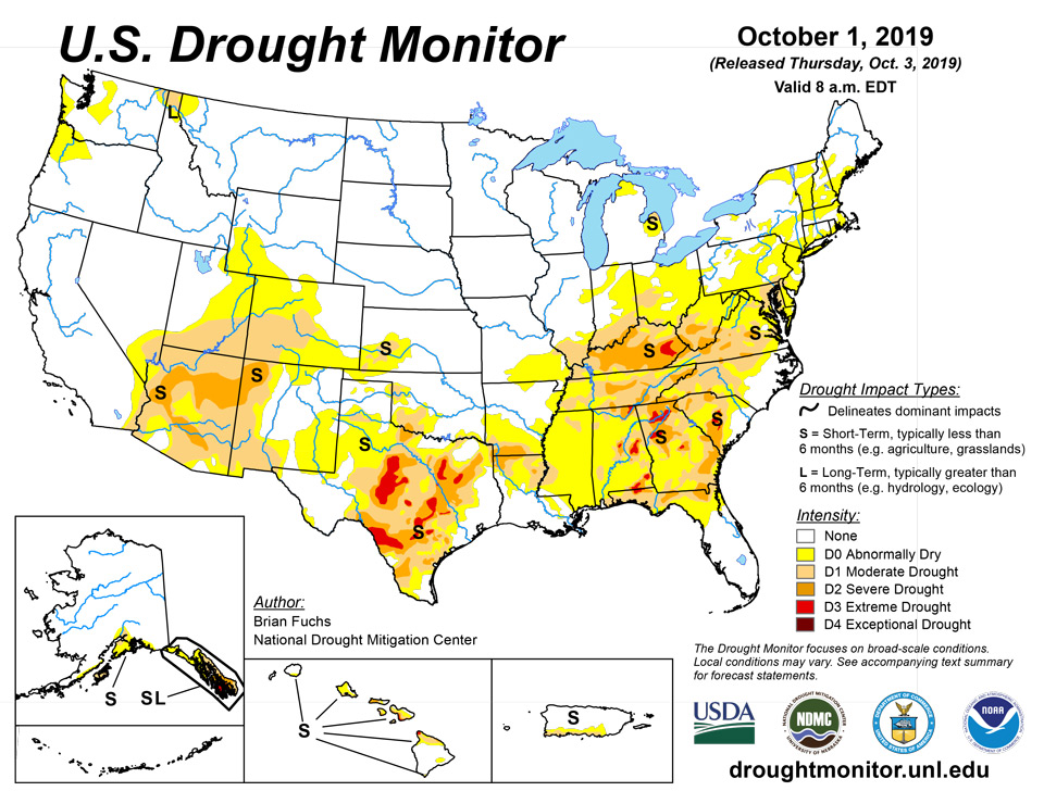
October 3, 2019 - Warmer than normal temperatures dominated the eastern two-thirds of the country, with many areas having temperatures that were 9 to 15 degrees above normal. Cooler than normal temperatures dominated the western portions of the country into the northern Rocky Mountains. Very dry conditions also dominated regions in the southern Plains, southern Midwest and along most of the east coast. The heat and dryness have continued setting the stage for rapidly developing drought, impacting mainly agricultural sectors right now.
Northeast
Temperatures were near normal in the northern portions of the region, 3 to 6 degrees above normal through the central, and 6-9 degrees above normal in the south, which has been consistent with the last 30 days. Most of the region was dry this last week with just areas of western Pennsylvania and along the border with Canada recording above-normal precipitation. The warm and dry pattern has expanded over much of the region and even down to the Mid-Atlantic. The only change made this week was to expand the abnormally dry conditions in eastern Massachusetts slightly to the north, capturing one of the drier areas and where streamflow levels are dropping. Degradation was also noted in West Virginia with an expansion of moderate and severe drought in the southern portions of the state while moderate drought was expanded in eastern Maryland.
Southeast
The warm and dry pattern continued over the region, with temperatures for the week generally 9 to 12 degrees above normal. Most of the region was dry with only small, isolated pockets of observed precipitation. Many areas had their warmest and driest September on record, accelerating the drought conditions in the region with dryness going back 8 to 10 weeks now with associated high temperatures. In areas from Virginia south into northern Florida, degradation was widespread, with many new areas of severe and extreme drought added. Outside of coastal areas impacted by recent tropical weather, almost the entire region is abnormally dry or worse, with many areas seeing multiple class degradation over the last several weeks. New areas of extreme drought were added to Kentucky, Alabama, Georgia, and South Carolina.
Midwest
Warmer than normal conditions dominated the region, helping to add some late growing degree days to the late planted crops. Temperatures were 9 to 12 degrees above normal in the southern portions while they were 6 to 9 degrees above normal farther to the north. A strong line of thunderstorms came across the region during the period, bringing with them significant rain over areas of Iowa, Illinois, Indiana, and Michigan. The southern portions of the region remained dry, especially over Kentucky, southern Indiana, Ohio, and Illinois. A mix of changes were made this week with a full category improvement over central Illinois and northern Indiana and into southern Michigan. Abnormally dry conditions were removed from eastern Iowa as well. Conditions rapidly continued to deteriorate over Kentucky and areas just north of Kentucky. Severe drought was expanded widely over Kentucky this week with a new area of extreme drought over eastern Kentucky. Most all the rest of Kentucky was downgraded to moderate drought while areas of southern Illinois, Indiana, and Ohio had moderate drought and abnormally dry conditions expand. Abnormally dry conditions were also expanded to cover much of southeast Missouri.
High Plains
Temperatures were warmest over the southern portion of the area and were actually below normal over the northern. Much of Kansas and Nebraska were 6-12 degrees above normal while North Dakota and portions of northern South Dakota were 3-6 degrees below normal. Precipitation was just as varied over the region with much of North Dakota, eastern Nebraska, and eastern Kansas recording over 200 percent of normal precipitation. Conditions were dry in western Kansas, Colorado, western Nebraska and southeast South Dakota. Some of these areas welcomed the drier weather while dryness and drought are becoming a concern in southwest Kansas and into Colorado. Abnormally dry conditions were expanded over southeast Colorado in response to the recent dryness.
South
Warmer than normal temperatures dominated the region, with most areas 6 to 12 degrees warmer than normal for the week. The warmest temperatures were in central Oklahoma to central Texas. Most areas were precipitation free this week with only portions of the Texas panhandle, northern Arkansas, and eastern Oklahoma having recorded significant precipitation. Most of the rain in the Texas panhandle was observed right at the data cutoff for this week with some improvements being made to moderate drought, but the area will be looked at again and drought will be assessed next week. Improvements were made in far northeast Texas in response to recent rains. Degradations were widespread in Texas with several new areas of extreme drought in central to eastern portions of the state and more severe drought being represented in the state. Drought was also expanded in portions of southern Arkansas, northern Louisiana and all of Mississippi.
West
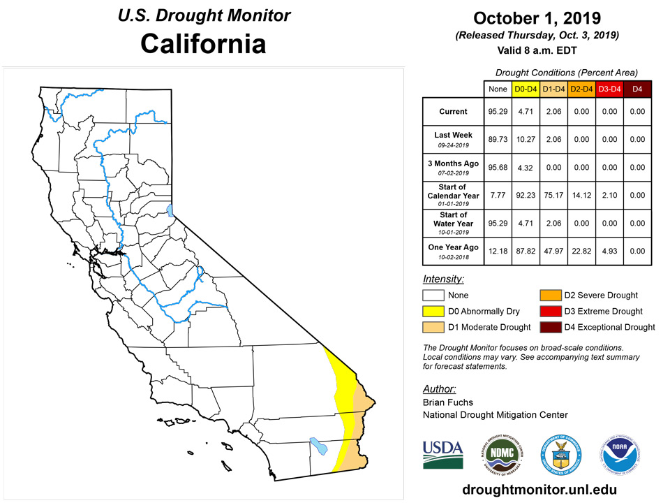
An active weather pattern was evident over the West this week with 4 to 5 feet of snow over portions of Montana, rain and snow in the Pacific Northwest, and rains over portions of the southwest. Areas from the Great Basin to the northern Rocky Mountains recorded over 400 percent of normal precipitation, with several feet of snow in portions of Montana. Rain was also observed in areas of southern California, southern Arizona and New Mexico. Improvements were made to the moderate drought in the Pacific Northwest, eliminating it from the region. The long-term dryness is still evident, but the short-term precipitation has allowed for the improvements. Abnormally dry conditions were also improved in western Washington and into western Oregon. In Arizona, the rains allowed for moderate drought to be improved in the central portion of the state and for the removal of abnormally dry conditions in the southeast portion of the state. Abnormally dry conditions were also removed from most of southern California.
Alaska, Hawaii, and Puerto Rico
In Hawaii, a small area of extreme drought was added on the southern tip of the Big Island in response to deteriorating conditions in that part of the state. In Puerto Rico, a full category improvement was made in response to tropical rains that came to the island. In Alaska, the short-term dryness that predicated much of the drought was improved upon. On the mainland of Alaska, a full category improvement was made except for Kodiak Island and in the panhandle of southeast Alaska, moderate drought was improved upon.
Pacific Islands
The weather pattern during this USDM week (9/25/19-10/01/19) was a continuation of the general pattern which has persisted for the last couple weeks: a surface trough stretched from the Marianas eastward just north of the Federated States of Micronesia (FSM) to portions of the northern Marshall Islands (RMI), while a surface ridge dominated southern portions of Micronesia for most of the week. Tropical disturbances or circulations moved through the trough, but they generally remained weak as they traversed USAPI waters. Upper-level troughs occasionally enhanced rainfall over the Marianas, Koror, and Yap, as well as parts of the RMI. The high pressure ridge kept much of the FSM dry for the week. South of the equator, a surface trough passed across American Samoa early in the week, but otherwise the weather was dominated by a strong high pressure ridge.
Satellite-based estimates of 7-day precipitation (QPE) showed two east-west bands of rainfall, one stretching from the East China Sea eastward across the northern portions of the Micronesia region, and the other stretching from New Guinea eastward to just north of the Samoan Island region. A band of 1 to 2 inches was indicated by the QPE across the southern Marianas to just north of Chuuk, another area of 1 to 2 inches was over parts of the RMI, and 0.5 to 1.0 inches was over parts of Palau and western Yap State. Otherwise less than half an inch was estimated by the QPE across the rest of Micronesia. In the Samoan region, an area of 1 to 2 inches touched American Samoa, and other areas were in the vicinity (mostly to the north and west), but less than half an inch was indicated for much of the immediate region.
The Republic of Palau had a dry week, with 1.18 inches of rain. This marks the third consecutive week Palau had less than its weekly minimum of 2 inches to meet most water needs. However, the monthly total for September was 8.74 inches, which is slightly over the 8-inches monthly minimum and the previous months were extremely wet, receiving about double their monthly minimum. For this reason, drought free (D-Nothing) conditions continued in Palau.
Drought free conditions persisted across the Mariana Islands this week since all three stations had more than the 1-inch of precipitation threshold to meet most water needs. Saipan had the least precipitation at 1.44 inches, while Guam had the most at 5.35 inches. Rota had 2.23 inches for the week. All three stations had 5 times their monthly minimum of 4-inches for the month of September.
Most of FSM had a dry week, with several locations receiving less than half an inch of rain. The station with the least precipitation was Kosrae with only 0.04 inch of rain. This week marked Kosrae and Pingelap’s (0.30 inch) second consecutive week with little to no rain. However, since the monthly precipitation total for September for both locations were more than the 8-inches threshold to meet most water needs at 9.77 inches and 8.10 inches, respectively, drought free (D-Nothing) conditions persisted this week.
This week marked the third consecutive week that Lukunoch had less than half of an inch of rain at 0.16 inch. The month of September had 6.43 inches of rain, which is less than the 8 inches monthly minimum. As a result, Lukunoch’s drought classification was changed from drought free status (D-Nothing) to abnormally dry (D0-S). Similarly, Nukuoro, Woleai, and Kapingamarangi’s drought status were also changed from drought free (D-Nothing) to abnormally dry (D0-S) since this also marked their third consecutive week with little rain ( 0.18 inch, 0.86 inch, and 1.01 inches, respectively).
Yap and Chuuk also had a dry week, with 1.42 inches (2 days of missing data) and 1.09 inches, respectively. Yap had close to 8 inches of rain for the month, while Chuuk’s precipitation total was nearly double the monthly threshold of 8 inches. Drought free (D-Nothing) conditions were unchanged for Yap and Chuuk.
Pohnpei was the only FSM region that had a wet week, receiving 2.21 inches of rain, retaining drought free (D-Nothing) status. The stations of Fananu and Ulithi had no data at the time of analysis and were set to missing.
Much of the Marshall islands had a wet week. Ailinglapalap, Kwajalein, Majuro, Jaluit, and Mili had over 2-inches of rain during the week, surpassing the weekly threshold of 2 inches to meet most water needs. The station with the most precipitation was Ailinglapalap with a total of 4.06 inches of rain. Majuro followed as one of the locations with the most precipitation at 3.35 inches of rain. Most of Majuro’s weekly rain fell on September 26 (1.65 inches), prompting floods in the main roads. Overall, Majuro’s September precipitation total was 11.73 inches, more than the 8 inches threshold. Ailinglapalap, Kwajalein, Majuro, and Mili’s drought status remained as D-Nothing.
Jaluit had a wet week (2.95 inches), which helped fill water catchments. However, dry conditions have persisted since April 2019 in Jaluit, where precipitation totals for the months were less than the threshold of 8 inches to meet most water needs. The months of July 2019 and August 2019 had the least monthly precipitation totals at 2.60 inches and 3.53 inches. For this reason, Jaluits drought status remained as severe drought (D2-SL).
The stations of Utirik and Wotje had the least precipitation across the Marshall Islands at 1.10 inches and 0.78 inch, respectively. Utirik’s September 2019 precipitation total was 12.22 inches, surpassing the threshold of 8 inches. For this reason, Utirik remained in drought free (D-Nothing) status this week.
Although Wotje had less than 1 inch of precipitation for this drought week, the September 2019 precipitation total was 8.50 inches and the month of August 2019 was also wet at 10.72 inches. For this reason Wotje’s drought classification was improved from moderate (D1-S) to abnormally dry (D0-S) conditions.
Pago Pago had 1.42 inches of rain this week, marking six consecutive weeks with precipitation totals below the 2-inches weekly threshold. The month of September had a total of 5.24 inches and it is 2.76 inches less than its monthly threshold of 8 inches. The stations located in Siufaga Ridge and Toa Ridge were also dry, reporting 0.76 inch and 0.94 inch, respectively. As a result, abnormally dry (D0-S) conditions persist in Tutuila.
Virgin Islands
St. Thomas had 1.18 inches of rain for the week at the Cyril E. King Airport. For the month of September, the total rainfall for this location was 3.51 inches or 63.0% of normal precipitation. Meanwhile, data for the CoCoRaHS station at Anna’s Retreat had a total of 2.42 inches for the month. The year-to-date rainfall total of 26.44 inches at the airport was 102.1% of normal precipitation as of October 1. The Grade School-3 Well level continued to be at high levels this week and SPI values at 1 (-0.38), 3 (1.19), 6 (0.23), 9 (0.2), and 12 (-0.03) months indicate drought free conditions. For this reason D-Nothing drought status was unchanged.
According to the NWS Climatology Report, St. Croix only had 0.54 inch of rain during this OCONUS drought week at the Henry E. Rohlsen Airport. Total rainfall for September 2019 was 1.88 or 38.7% of normal precipitation for this location. Meanwhile the CoCoRaHS station at Christiansted had a total of 0.86 inch of rain for the week and 6.28 inches for the month. The year-to-date value of 18.36 inches was 73.5% of normal at the airport. Groundwater levels at the Adventure 28 well continued to be low as of October 1. SPI values at the Henry E. Rohlsen Airport were mixed, suggesting neutral conditions at 3 (-0.04) and 6 (-0.05) months, while suggesting abnormally dry to moderate drought in the 1 (-1.15), 9 (-0.71), and 12 (-1.02) months. Drought free conditions remained this week, however, if conditions persist, a change to abnormally dry might be considered next week.
According to data provided by a volunteer observer, St. John’s weekly precipitation total was 1.53 inches. The September 2019 rain total of 3.99 inches was 65.6% of normal. The year-to-date precipitation was 28.02 inches, which is 89.9% of normal. SPI values at all levels were wet or neutral, indicating drought free (D-Nothing) conditions.
Looking Ahead
Over the next 5-7 days, precipitation is anticipated to continue over the Midwest, Plains and areas of the Southwest, with the greatest amounts anticipated over Kansas and Missouri. Precipitation tries to work farther south, with areas of Kentucky and Tennessee and West Virginia being at the center of the greatest precipitation totals of 1 to 2 inches. Dry conditions are expected over much of the West as well as from the Mid-Atlantic to Florida. Temperatures during this time are forecast to be above normal over the Southeast and Southwest, with departures of 3 to 6 degrees above normal. Cooler than normal conditions are expected over the Plains and Pacific Northwest with temperatures 3 to 6 degrees below normal.
The 6-10 day outlooks show that the Plains, upper Midwest, and Southwest, including western Alaska, has above-normal chances of observing above-normal temperatures, with the greatest chances over the Southwest and Southeast. The Pacific Northwest and southeast Alaska have above-normal chances of below-normal temperatures. The areas that have the greatest chances of above-normal precipitation during this time are along the east coast, Alaska, and the Pacific Northwest. Much of the Plains, Midwest, South, and Rocky Mountains have the greatest chances of below-normal precipitation.
Author(s):
Brian Fuchs, National Drought Mitigation Center
Ahira Sanchez-Lugo, NOAA/NCEI
Dryness Categories
D0 Abnormally Dry—used for areas showing dryness but not yet in drought, or for areas recovering from drought.
Drought Intensity Categories
D1 Moderate Drought
D2 Severe Drought
D3 Extreme Drought
D4 Exceptional Drought
Drought or Dryness Types
S Short-Term, typically less than 6 months (e.g. agricultural, grasslands)
L Long-Term, typically greater than 6 months (e.g. hydrologic, ecologic)
Source: National Drought Mitigation Center

