


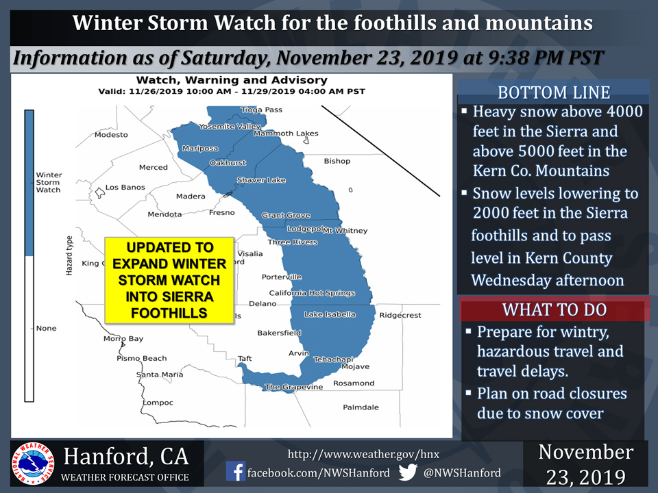
November 24, 2019 - The National Weather Service Hanford Office reports a Winter Storm Watch is in now effect for the foothills and higher elevation of the Sierra in addition to the Kern county mountains from midday Tuesday through Thursday night.
For our Central California Interior followers here is the NAM12 Model projection of the timing of incoming precipitation on Tuesday through early Wednesday. The model only extends through 4 AM Wednesday but it is a good snap shot of arrival time. #CAwx pic.twitter.com/cBVGDRz2kG
— NWS Hanford (@NWSHanford) November 24, 2019
Accumulating snow will begin over the higher elevations of the Sierra by midday Tuesday then spread southward into the Kern county mountains by midday Wednesday.
The arrival of colder air will lower snow levels to 2000 feet in the Sierra foothills and the Kern county mountain passes Wednesday afternoon.
Snow levels could drop as low as 1500 feet in the Sierra foothills and 2500 feet in the Kern county mountains by Thanksgiving Day morning.
A Winter Storm Watch means there is potential for significant snow accumulations that may impact travel.
Travel could be extremely difficult or impossible.
If you plan to travel, check ahead on road conditions as some roads could become closed or impassable.
If you must travel, remember to carry tire chains, plenty of food, a good deal of water, and warm clothing in your vehicle.
For information on road conditions, including closures or delays, call Caltrans at 1-800-427-7623 or visit http://www.dot.ca.gov/cgi-bin/roads.cgi.
Winter Storm Watch
URGENT - WINTER WEATHER MESSAGE
National Weather Service Hanford CA
901 PM PST Sat Nov 23 2019


Central Sierra-North Kings River-Sequoia Kings-Lake Isabella-
Tehachapi Area-Fort Tejon-
Including the cities of Devils Postpile, Florence Lake,
Lake Thomas Edison, Tuolumne Meadows, Bass Lake, Fish Camp,
Wawona, Shaver Lake, Camp Nelson, Giant Forest, Lodgepole,
Grant Grove, Johnsondale, and Tehachapi
901 PM PST Sat Nov 23 2019

...WINTER STORM WATCH REMAINS IN EFFECT FROM TUESDAY MORNING
THROUGH LATE THURSDAY NIGHT ABOVE 2000 FEET...

* WHAT...Heavy snow possible. Several feet of snow is likely in
  the Sierra above 4,000 feet and in the Kern County Mountains
  above 5,000 feet. Several inches of snow could accumulate in the
  Sierra foothills between Wednesday afternoon and Thursday
  evening. Accumulating snow is possible as low as 1,500 feet by
  Thanksgiving Day morning.

* WHERE...Foothills and higher elevations of the southern Sierra
  in addition to the Kern County Mountains.

* WHEN...From midday Tuesday through late Thursday night.

* IMPACTS...Slick, snow-covered roads and potentially dangerous
  and treacherous driving conditions along with possible travel
  delays and road closures. Blowing and drifting snow and local
  whiteout conditions likely over the higher elevations of the
  Sierra along with sub zero wind chill temperatures.

* ADDITIONAL DETAILS...Significant reductions in visibilities
  are possible. Downed trees and power outages possible.

PRECAUTIONARY/PREPAREDNESS ACTIONS...

Please monitor the latest NWS forecasts for updates on this
storm.
Source: NWS
