


California and National Drought Summary for December 17, 2019
Summary
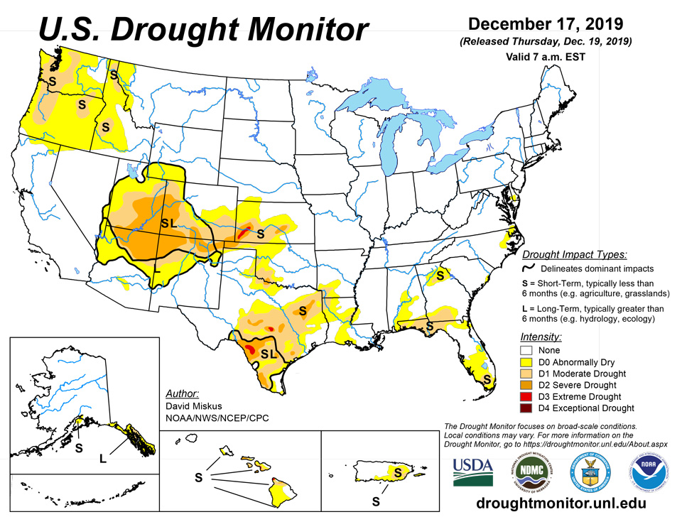
December 19, 2019 - A series of Pacific fronts brought welcome moisture to the Northwest (from northern California northward into Washington), but even with this precipitation, the Water Year to Date (WYTD; since Oct. 1) basin average precipitation and Snow Water Content (SWC) were still well below normal (30-70%). Farther east, frigid Arctic air (weekly average temperatures up to 15 degree F below normal) was bottled up in the northern Plains and upper Midwest (and central Canada), while the West, South, and East observed above-normal readings (weekly temperature anomalies + 3 to 6 degree F). As the fronts progressed eastward, they slowed and waves of low pressure developed along the fronts, generating widespread rains (1-4 inches, locally to 8 inches) in the Southeast, mid-Atlantic, and along coastal New England. In the colder air to the north, the precipitation fell as snow, blanketing parts of the lower Missouri and Ohio Valleys, northern Appalachians, eastern Great Lakes region, and interior New England with light to moderate totals (2-6 inches). In contrast, the Southwest, Plains, and western Corn Belt were mainly dry. In Alaska, above-normal temperatures prevailed across the state, with decent precipitation observed along the southern coast. Shower activity increased across the eastern Hawaiian Islands, allowing for some improvements on the Big Island.
Northeast
With much of the region experiencing at or above-normal precipitation (wetness) in both the short- and long-terms and above-to much-above normal USGS stream flows, the only area with drought or abnormal dryness was parts of the Delmarva Peninsula (D0). And with this week’s widespread light to moderate precipitation (0.5-2 inches, locally to 3.5 inches), it was assured that there would be no D0 expansion or new D1development. In the Delmarva D0 area, however, even though 1.5-2 inches of rain fell, there were still some persistent medium-term deficits (4-8 inches at 6-months). In addition, with lingering hydrologic impacts (average 7-, 14-, and 28-day USGS stream flows in the 10-24th percentile), some D0 was left where the largest deficits and lower stream flows still existed.
Southeast
A slow-moving cold front with waves of low pressure developing along it produced moderate to heavy rains (2-4 inches, locally to 8 inches) in most of Alabama, Georgia, and the western halves of the Carolinas. This heavy precipitation fell on much of the D0-D2 area of north-central Georgia and west-central South Carolina, effectively eliminating all short-term deficits in South Carolina and greatly reducing the deficiencies in Georgia. As a result, a 2-category improvement was made in west-central South Carolina, and a 1-category improvement occurred in north-central Georgia. Similarly, southeastern Alabama, northwestern Florida Panhandle, and southeastern Georgia saw a 1-cat reduction in drought as heavy rains also eliminated or greatly diminished short-term deficiencies. Heavy showers along Florida’s Atlantic Coast eased short-term D0 there. In contrast, the rains (less than 0.5 inches) missed portions of eastern North Carolina, the central coast of South Carolina, and extreme southern Florida, increasing 60- and 90-day shortages that required the development of new D0 in the first two areas and an expansion of D1 in the latter region.
South
While western sections were dry (Oklahoma, western two-thirds of Texas, western Arkansas), precipitation gradually increased across eastern sections, with scattered lines of showers and thunderstorms dropping light to moderate totals (1 to 3 inches) on parts of Louisiana, Mississippi, and Tennessee. The rains were enough to provide some slight improvement in northern and central Louisiana (D0 and D1 shrunken), but much lighter amounts in southwestern Arkansas and eastern Texas, along with slightly above-normal temperatures, somewhat increased the area of D0-D2 in those 2 areas. In western Oklahoma, conditions were maintained as November and December precipitation is normally quite low this time of year (each month contributes to 1-2% of the annual total), and seasonable temperatures helped.
Midwest
Precipitation was generally light (0.25-0.5 inches) across the Midwest, with most of it falling as snow. The upper Midwest was especially cold, with weekly temperatures averaging 5 to 15 degrees F below normal, while the remainder of the region was slightly below normal. The Midwest continued to remain drought-free as most locations were either normal or wet in both the short- and long-terms. There were some spotty areas with subnormal precipitation at 30-, 60-, and 90-days, but they varied in location and time. An area to watch for D0 development could be northwestern Missouri and southern Iowa (dry at 30- and 60-days), although they were wet at 90-days. With decent widespread top and subsoil moisture, low temperatures, frozen soils, minimal evaporation, near to above normal stream flows, and fairly good snow cover, it could be a while before drought re-emerges in the Midwest.
High Plains
Most of the Plains saw little or no precipitation this week, with some light snow falling across North Dakota, southeast Wyoming, Nebraska, and eastern Kansas (for Colorado, refer to the West). The frigid Arctic air was mostly confined to the northern Plains and upper Midwest (weekly TANs -5 to -10 degrees F), although some colder air spilled southward and eastward into the central Plains and Midwest. With this time of the year being climatologically dry, typically cold with little or no evaporation, and with frozen soils, it is a difficult time for drought to develop and expand in most northern areas. Plus, all short- to long-term indices are near to above normal (wet) in the northern Plains. Farther south, however, much drier conditions existed in southwestern Kansas (D2 to D3), especially during the 3- to 6-month range. After 1 to 2 category deteriorations were made the past 4 weeks, no changes were made here this week.
West
After several wet weeks in the Southwest (and much improvement), tranquil weather returned to most of the region. With SNOTEL WYTD basin average precipitation and SWE values in the Southwest generally at or above normal, this region was generally left unchanged. The exceptions to this was across northern Nevada and southern Idaho where light to moderate precipitation (0.5-2 inches) fell, producing positive SPIs (wet) at 1-, 2-, 3-,4-, 6-months, and beyond, along with above-normal USGS stream flows. As a result, D0 was removed in these 2 areas. In northern Utah and most of Colorado, light to moderate precipitation continued to provide drought relief, especially in the central and southern Rockies where a 1-category improvement was made in central Colorado and extreme northern New Mexico. The area of northern Utah was already drought-free.
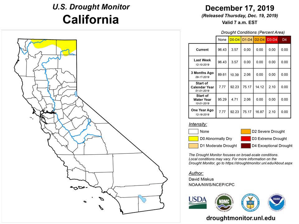
In contrast, the Northwest (from northern California northward into Washington) finally received welcome and widespread precipitation (2-4 inches along the coast and in the Cascades and Sierra Nevada, locally to 10 inches in extreme northwestern California), but this Water Year has seen far too few weeks like this. This situation is further exacerbated by the fact that this is the wet season (large normal totals) so that even light precipitation can quickly accumulate huge deficits. Thus, even with this week’s precipitation, many stations SPIs at 30-, 60-, 90-days, and longer time periods were at D2-D4 levels; USGS 1-, 7-, 14-, and 28-day average stream flows were at near- or record lows (tenth percentile or less); 90-day deficits exceeded a foot (and more) in western Washington and Oregon; SNOTEL basin average WYTD precipitation ranged between 34-60% and Dec. 18 SWC was between 27-65%. Accordingly, D1 was introduced to the Washington and Oregon Cascades, northeastern Oregon, and northern and southwestern Idaho where the driest tools converged. In addition, D0 was expanded into central Washington, central Idaho, and western Montana.
Alaska, Hawaii, and Puerto Rico
In Alaska, another week of above-normal temperatures (weekly TANs +5 to 20 degrees F) and light to moderate precipitation (1-4 inches, locally to 12 inches) along the southern coast maintained conditions there. An exception was on the eastern Kenai Peninsula where 6-12 inches of precipitation effectively erased the D0(S) there, although the western section observed much lower totals (0.5-2 inches), and D0 remained there. To the east, most southeastern Alaskan Panhandle stations received near to below normal December precipitation, but mountain snow accumulations have been below normal with the milder conditions, limiting the amount of snow melt inflow into hydroelectric reservoirs.
In Hawaii, rainfall has increased across many of the windward areas, along with some of the leeward sides. The FSA reported that the South Point area of the Big Island had improved, thus a 1-cat improvement was made. On the northeast side of the Big Island, recent rainfall over parts of Hamakua and North Hilo Districts also improved conditions, so the D0-D1 gradient was shifted northwest. Elsewhere, NDVI data showed that conditions have deteriorated over Lanai, so D0 was replaced by D1. The remaining islands were left as is.
In Puerto Rico, heavy rains (2-4 inches, locally to 10 inches) fell across eastern third of the island, somewhat shrinking the D0 and D1 areas there. Although short-term deficits remained, the rains were enough to markedly increase root zone soil saturation (as of Dec. 15), and D1 was improved to D0 where more than 4 inches fell and root zone saturation exceeded 80%. Similarly, D0 was removed along the northeastern coast where more than 3 inches of rain fell, and 60- to 90-day surpluses now existed.
Pacific Islands
During this USDM week (12/11/19-12/17/19), high pressure and strong trade-wind flow dominated northern Micronesia, especially the Marianas, while a near-equatorial trough persisted across southwestern Micronesia and other surface troughs developed over eastern portions of southern Micronesia. Convergence in the trade-wind flow was created by surges in the trade winds, while weak circulations developed in the southern and eastern troughs. Upper-level divergence occasionally enhanced showers generated by the surface convergence. South of the equator, a surface trough lingered near the Samoan Islands throughout the week.
Satellite-based estimates of 7-day precipitation (QPE) showed bands of 2+ inches of rain, with locally 4+ inches, across parts of Palau, western and eastern parts of the Federated States of Micronesia (FSM), and southern parts of the Marshall Islands (RMI). Areas of 1-2 inches spread southward to the equator. Little to no widespread rainfall was indicated on the QPE across the Marianas and northern RMI. Areas of 1+ inches of rainfall, with locally 2-4 inches, were indicated across much of the Samoan Island region.
With 2.07 inches of rain for this week and 6.53 inches so far this month, Palau is wetter than the weekly and monthly (through half-way point in the month) minimums needed to meet most water needs, and it has been wet (above monthly minimum) for the previous 6 months, so D-Nothing continued.
In the Marianas, the last 2 weeks have been dry (below weekly minimum) for Guam and Rota and (depending on the observation site) Saipan. But 3 weeks ago it was wet, and the previous several months have been wet, so D-Nothing continued. But these 3 stations will be watched for D0-S if the dryness continues.
In the FSM, Fananu has been missing for the last couple months and Pingelap has been missing for at least a month, so an analysis could not be made for these two locations. Based on data received so far this week, it was wet (more than the 2-inch weekly minimum) at Pohnpei (5.31 inches) and Kosrae (2.90) but dry at the remaining FSM stations. Lukonor reported 0.77 inch of rain and Woleai 0.71 inch (with 1 day missing), and both stations have been dry for the last 2-3 weeks and for several months before, so D0-S continued. For most of the remaining stations, this week marked the second consecutive dry week, but prior weeks and months were wet, so D-Nothing continued. However, some of them will be watched for D0-S if the dryness continues. For example, this was the third consecutive dry week at Nukuoro; D0-S was not added this week because 3 weeks ago (11/27-12/3) the rainfall total was 1.98 inches – while technically less than the 2-inch weekly minimum, it was close and basically still a “wet” week. But if next week is dry, then that would make 4 consecutive “dry” weeks.
Most of the RMI stations were dry this week. Three exceptions were Jaluit (2.40 inches for the week), Ailinglapalap (2.29 inches), and Utirik (2.89 inches). This week marked the second consecutive dry week at Kwajalein and Wotje, but previous weeks and months were wet. The latest (December 11) report for the Majuro reservoirs showed storage at 31.088 million gallons, which is 86.4% of maximum and well above the 80% threshold for drought concern. D-Nothing continued at all of the RMI stations.
It was a wet (more than the 1-inch weekly minimum) week at Pago Pago (2.57 inches) and the automated stations at Siufaga Ridge (1.68) and Toa Ridge (1.73). With this and previous weeks and months wet, D0-S continued at Tutuila.
Virgin Islands
The weather conditions across the U.S. Virgin Islands (USVI) during this USDM week (12/11/19-12/17/19) were influenced mostly by the North Atlantic High. The strong surface high over the Atlantic drove easterly trade winds across the USVI which brought low-level moisture with them. Trade-wind showers tracked mostly across the northern islands and the showers were enhanced occasionally by a nearby upper-level trough.
Radar-based estimates of rainfall for the 7 days ending at 12z on Tuesday depicted 2 or more inches of rain across much of St. John island and eastern St. Thomas, about an inch on western St. Thomas and western St. Croix, and half an inch or less across eastern St. Croix.
The Henry Rohlsen AP had only 0.14 inch of rain this week, while the Christiansted 1.8 ESE CoCoRaHS station measured 0.90 inch and the Christiansted 4.1 ESE CoCoRaHS station measured 0.86 inch. The station at East Hill reported 0.72 inch for the week and 1.14 inches for the month, or 66% of normal for the month. AHPS estimates for 7-day precipitation showed a gradient across the island, with the western end wetter (over an inch) than the eastern end (less than 0.25 inch). The USGS Adventure 28 well is showing no recovery and is still getting lower. NDMC’s computation of the SPI (Standardized Precipitation Index) for Rohlsen AP and East Hill showed little change from the values for last week, so the USDM status for St. Croix continued at D1-SL.
AHPS radar estimates show most of the island of St. Thomas wet for the last 7 days, with rainfall estimates ranging from an inch over the west to 2 inches in the east. The Cyril E King AP station reported 0.83 inch of rain for this week, with a month-to-date total of 1.65 inches which is slightly less than normal. The year-to-date total is 33.85 inches with a departure of -4.24 inches or 89% of normal. The Anna's Retreat 2.5 ESE CoCoRaHS station reported 1.60 inches of rain for the week. The USGS Grade School 3 well is still low, but it rose 1.3 feet this week. The NDMC computations of this week’s SPI for King AP showed improvement at the 1-month time scale but little to no change at the 2- to 12-month time scales. Moderate drought is still evident for the last 60 days and abnormal dryness at the 12-month time scale, so D0-S continued on St. Thomas.
According to AHPS radar estimates, 2 inches or more of rain fell across most of the island of St. John this week. The station at Windswept Beach reported 2.72 inches for December 11-16, and the USGS Susannaberg well is still locally low, but it rose a foot this week. Windswept Beach had a monthly total precipitation of 3.47 inches, which is about 179% of the long-term average for the first half of December. But November was so dry that the November 1-December 16 total of 5.41 inches is still only 59% of average for that time period, and the station is below average (62%) for October 1-December 16 and for the last 3 months (63% for September 1-December 16). This week’s rain improved the SPI, but it is still in the D0 range for the last 3 months and last 12 months. As a result, the USDM status for St. John was improved just one category, to D0-S.
Looking Ahead
During the next 5 days (December 19-23), most of the lower 48 States will be tranquil (dry), except for heavy precipitation (more than 4 inches) in the Pacific Northwest (from northern California northward), and in the southeastern quarter of the Nation (2-5 inches in the central and eastern Gulf and southern Atlantic Coasts). If this rain occurs, parts of Florida may close in or break their record high December amount, effectively wiping away any existing drought. The upper and eastern Great Lakes region should see snow showers along favored locations. 5-day temperatures should average above-normal for much of the contiguous U.S.
The CPC 6-10 day outlook (December 24-28) favors above-normal precipitation across the Southwest, Plains, and upper Midwest, and in southern and eastern Alaska. Subnormal precipitation is likely along the Atlantic Coast and Montana. Temperatures are expected to average below-normal in the Far West and Alaska, with good odds for unseasonably mild readings in the eastern half of the Nation.
Author(s):
David Miskus, NOAA/NWS/NCEP/CPC
Richard Heim, NOAA/NCEI
Dryness Categories
D0 Abnormally Dry—used for areas showing dryness but not yet in drought, or for areas recovering from drought.
Drought Intensity Categories
D1 Moderate Drought
D2 Severe Drought
D3 Extreme Drought
D4 Exceptional Drought
Drought or Dryness Types
S Short-Term, typically less than 6 months (e.g. agricultural, grasslands)
L Long-Term, typically greater than 6 months (e.g. hydrologic, ecologic)
Source: National Drought Mitigation Center

