


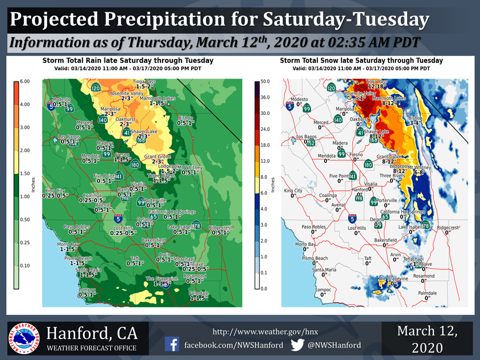
Projected rainfall totals from Saturday through Tuesday for Mariposa: 2.00" to 3.00"
Projected rainfall totals from Saturday through Tuesday for Oakhurst: 2.00" to 3.00"
Projected rainfall totals from Saturday through Tuesday for Yosemite Valley: 2.00" to 3.00"
March 12, 2020 - The National Weather Service releases forecast precipitation amounts for this weekend into early next week.
  Area Forecast Discussion
  National Weather Service Hanford CA
  320 AM PDT Thu Mar 12 2020

  .SYNOPSIS...An low pressure system will move slowly east toward
  the southern California coast today then move inland tonight.
  This system will spread wrap around moisture into the southern
  portion of our area and bring another day with afternoon and
  evening showers and thunderstorms to Kern County. This system
  will move east of the area on Friday with dry weather and a
  warming trend taking place. A colder storm system drop southward
  into the area Saturday night and Sunday bringing increased
  precipitation chances and cooler temperatures.

  &&

  .DISCUSSION...Skies cleared out across much of our area during
  the evening. Some upslope clouds are banked up along the slopes
  of the mountains in Kern County; however, producing local mountain
  obscurations and visibility reduction. The southerly fetch of
  tropcial moisture is now situated to the east of our area, and as
  a result the precipitation has also moved to the east of our area.

  SREF indicating the low pressure system now situated near 30N/123W
  which was responsible for brining the increased moisture and
  instability to our area is expected to slowly track eastward
  toward the Socal coast today and move inland tonight. As the low
  moves east some wrap around moisture is expected to be pulled into
  the southern portion of our CWFA this afternoon and evening. With
  LI/s progged to be between -2 and 0 DEG C and CAPES between 200
  and 600 J/KG this afternoon over Kern County have increased POPS
  and added mention of a slight chance of thunderstorms for the
  Kern County Mountains and Deserts as well as for the far south
  end of the San Joaquin Valley. North of Kern County, daytime
  temperatures are expected to rise well above seasonal normals as
  morning sunshine will be more abundant during the morning and
  early afternoon hours.

  The low is expected to move into the Desert Southwest on Friday
  giving way to a dry northwest flow over central CA which will push
  out the wrap around moisture over the southern portion of our
  area and provide for another day of above normal temepratures
  north of Kern County.

  WRF indicating a cold low pressure system approaching the PAC NW
  coast Friday night which will then take a southward turn on
  Saturday. The medium range models are trending a bit slower with
  the southward progression of this system over the weekend, but
  still advertise it to drop southward off the CA coast on Monday
  then move it slowly inland on Tuesday and Wednesday. Although the
  models have had difficulty handling the exact placement and
  timing of this feature, the models are consistent in advertising a
  blocky pattern early next week with a deep trough prevailing over
  the western CONUS coast. This will result in temperatures
  trending downward over the weekend and lowering to unseasonably
  cool readings by early next week. Precipitation chances will
  increase across the area by Saturday night and precipitation will
  become likely over the area on Sunday and Monday. Unsettled
  conditions will then prevail across our area through the middle
  of next week as the low moves slowly inland over central and
  southern CA.
Source: NWS

