


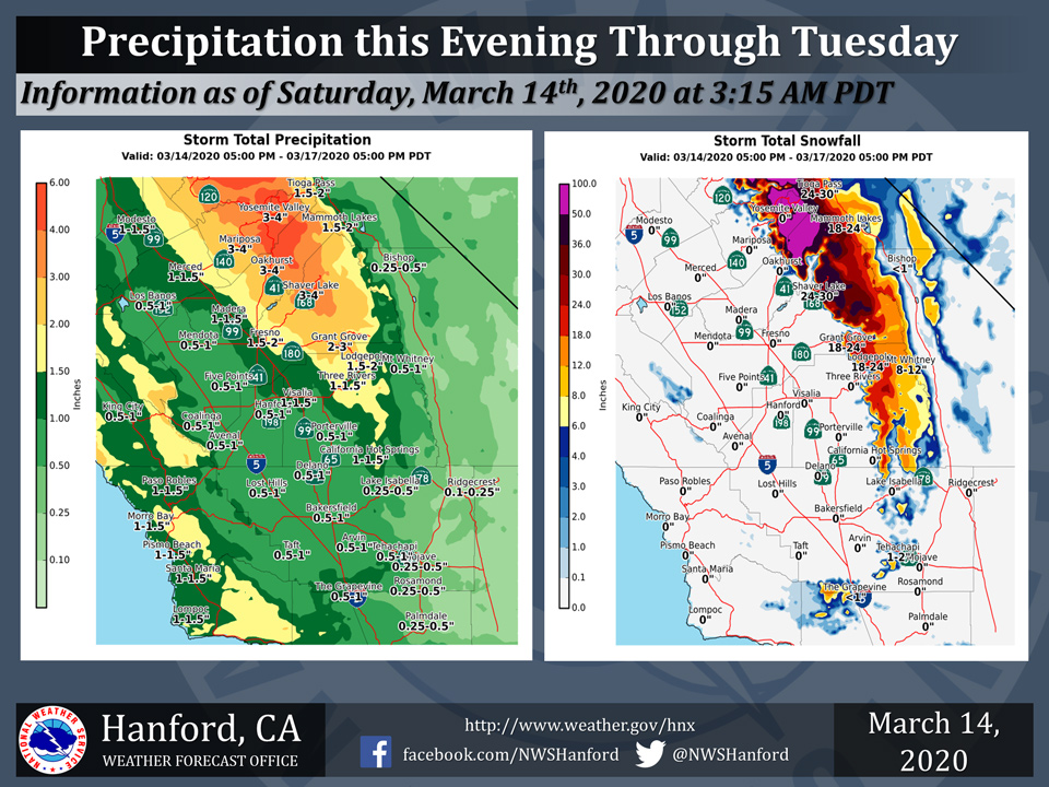
Projected rainfall totals from Saturday through Tuesday for Mariposa: 3.00" to 4.00"
Projected rainfall totals from Saturday through Tuesday for Oakhurst: 3.00" to 4.00"
Projected rainfall totals from Saturday through Tuesday for Yosemite Valley: 3.00" to 4.00"
March 14, 2020 - The National Weather Service Hanford Office reports a series of storm systems will impact Central California starting by this evening and continuing into early next week.
Significant snow will be likely in much of the Sierra Nevada this weekend through early next week.
Light snow accumulations are possible Tuesday at pass levels in Kern County, including Tejon Pass along Interstate 5 and Tehachapi Pass along Highway 58.
The majority of this precipitation will fall on Sunday through Monday afternoon.
  Area Forecast Discussion
  National Weather Service Hanford CA
  333 AM PDT Sat Mar 14 2020

  .SYNOPSIS...
  Dry weather will prevail across most of Central California today.
  A storm system will meander off the coast of the Golden State
  tonight into the middle of next week. Precipitation will slowly
  spread southward across Central California tonight through Sunday
  night. Widespread precipitation is expected throughout the
  forecast area early next week.

  &&

  .DISCUSSION...
  A low pressure system will move southward, just off the coast of
  the Pacific Northwest today. Precipitation associated with this
  storm system should generally remain north of Central California
  today. Ahead of this approaching low pressure system, strong,
  gusty southerly winds are expected this afternoon into tonight in
  most of the San Joaquin Valley, in the West Side Hills, and in the
  Southern Sierra Nevada foothills of Mariposa, Madera, and Fresno
  Counties. A Wind Advisory is in effect for those locations.

  The aforementioned storm system will slowly progress southward,
  just of the coast of the Golden State tonight through early next
  week. Precipitation associated with this storm system will slowly
  spread southward through Merced, Mariposa, and Madera Counties
  tonight. Precipitation should make it as far south as Fresno
  County Sunday. Widespread precipitation is expected throughout
  Central California early next week. Winter Storm Warnings and
  Watches are in place for the Southern Sierra Nevada above 4000
  feet. The snow level should drop below pass levels in the Kern
  County mountains Monday night. This may set the stage for a
  particularly difficult travel day Tuesday across the highest
  elevations of Interstate 5 and Highway 58. One to three inches of
  snow is conceivable on Tejon Pass and Tehachapi Pass Tuesday. A
  Winter Weather Advisory may be needed for the Kern County
  mountains for Monday night into early Wednesday morning.

  A short wave ridge of high pressure should build over the Golden
  State Wednesday night through Friday night, resulting in a period
  of dry weather. The next storm system may impact Central
  California next weekend.
Source: NWS

