


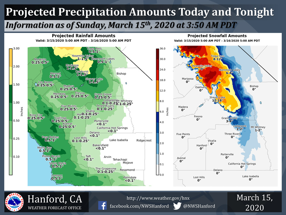
Projected rainfall totals for Sunday for Mariposa: 1.00" to 1.50"
Projected rainfall totals for Sunday for Oakhurst: 1.00" to 1.50"
Projected rainfall totals for Sunday for Yosemite Valley: 1.00" to 1.50"
March 15, 2020 - The National Weather Service Hanford Office reports precipitation will slowly spread southward across Central California today and tonight.
Heavy rainfall is likely in the Mariposa and Madera County foothills.
A Winter Storm Warning is in effect for the Mariposa, Madera, and Fresno County portion of the Southern Sierra Nevada above 4,000 feet.
  Area Forecast Discussion
  National Weather Service Hanford CA
  401 AM PDT Sun Mar 15 2020


  .SYNOPSIS...
  Low pressure will move down the California coast through Tuesday
  with most areas having a chance of lower elevation rain and
  mountain snow. The low will then move east of the area by midweek;
  however, a trough of low pressure will remain over the West for a
  continued cool and potentially showery pattern.

  &&

  .DISCUSSION...Scattered light rain showers have been falling in
  parts of the San Joaquin Valley and into the Sierra foothills
  so far tonight. A few spots have been gusting over 35 miles per
  hour in the West Side Hills, so will keep the Wind Advisory going
  through this morning. The upper-level low remains centered off
  the coast of Northern California and has made little southward
  progression since yesterday. Expect shower activity to gradually
  spread southward by later today, while precipitation amounts will
  likely increase by later this afternoon and into the evening.
  Otherwise, expect a relatively cool day today. More widespread
  precipitation will spread further south by Monday, including into
  Kern County, as the low pressure system and associated trough move
  southward off the California coast.

  Due to the slow progress of the low pressure system, it now
  appears forecast precipitation amounts could lower a bit for
  today through Tuesday. Nonetheless, snow projections remain
  around 3 to 4 feet in the higher elevations of the Sierra Nevada
  through Tuesday, mainly north of Kings Canyon NP. Amounts of one
  to 2 feet are possible in Sequoia NP at 7000 feet. Rain amounts
  reach anywhere from 0.50 to 1.00 inch in the southern and western
  sides of the San Joaquin Valley, though could be as high as one
  to two inches on the east side of the San Joaquin Valley from
  Fresno County northward. Expect 2 to 3 inches in the Sierra
  foothills from Mariposa to Fresno County and around 1.00 to 1.50
  inches in the foothills of Tulare County. Most of the
  precipitation is expected to occur on Monday throughout much of
  the Central California interior.

  This low will continue its progression on Monday into Tuesday and
  will likely be off the coast of Southern California. Colder air
  will flow southward into Kern County, and the threat for
  accumulating snow on the mountain passes remains. A dusting up to
  2 inches of snow is still possible on the Grapevine and Tehachapi
  Pass, mainly on Monday evening into Tuesday morning. Precipitation
  is expected to taper off by Tuesday afternoon, though a cold
  airmass will likely be in place over much of Central California
  that could kick off some instability showers, while a thunderstorm
  cannot be ruled out.

  For Wednesday and beyond, cool and unsettled weather will remain
  as models show the trough remaining over much of the Western U.S.
  Showers will continue to be a possibility until at least next
  weekend, though there may be some brief breaks at times later in
  the week. It does not appear any well above average temperatures
  will return over the next seven days like what occurred on some
  days during the last couple of weeks.
  Source: NWS

