


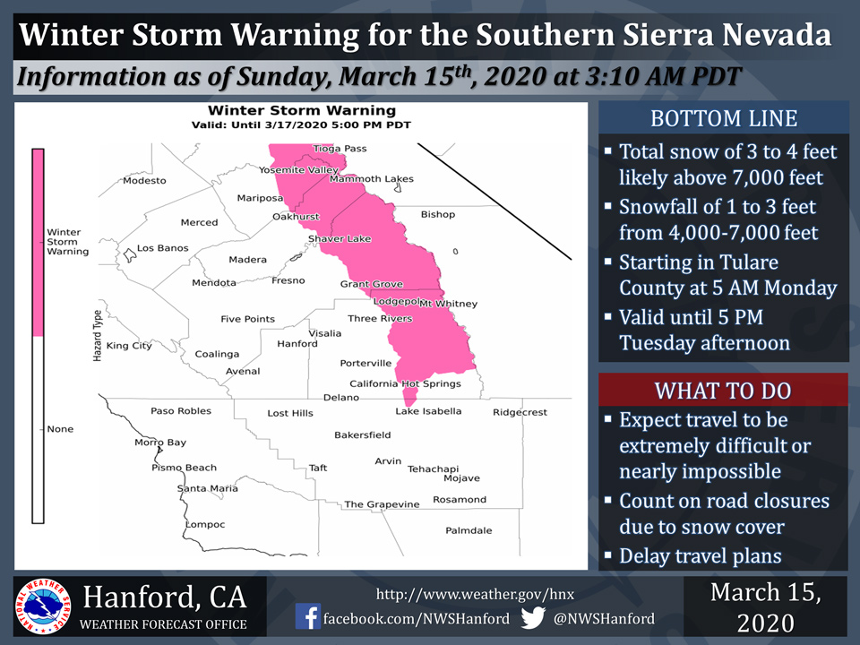
March 15, 2020 - The National Weather Service Hanford Office reports a Winter Storm Warning is in effect for the Southern Sierra Nevada above 4,000 feet until 5:00 P.M. Tuesday afternoon.
Light snow should begin in the Tulare County portion of the Southern Sierra Nevada Monday morning.
Heavy snow is not expected in the Tulare County portion of the Southern Sierra Nevada until Monday afternoon.
Winds will gust as high as 60 mph on exposed ridgetops and near the crest.
Gusty winds may bring down tree branches.
Travel will be extremely difficult or nearly impossible.
If you plan to travel, consider alternate strategies.
If you must travel, remember to carry tire chains, plenty of food, a good deal of water, and warm clothing in your vehicle.
For information on road conditions, including closures or delays, call Caltrans at 1-800-427-7623.
Winter Storm Warning
URGENT - WINTER WEATHER MESSAGE
National Weather Service Hanford CA
259 AM PDT Sun Mar 15 2020

Central Sierra-North Kings River-
Including the cities of Devils Postpile, Florence Lake,
Lake Thomas Edison, Tuolumne Meadows, Bass Lake, Fish Camp,
Wawona, and Shaver Lake
259 AM PDT Sun Mar 15 2020

...WINTER STORM WARNING NOW IN EFFECT UNTIL 5 PM PDT TUESDAY...
...WINTER STORM WATCH IS NO LONGER IN EFFECT...

* WHAT...Heavy snow above 4000 feet. Total snow accumulations of
  30 inches to 4 feet with locally higher amounts above 7000 feet
  and 18 to 30 inches from 4000 to 7000 feet. Winds gusting as
  high as 60 mph on exposed ridgetops and along the crest.

* WHERE...Southern Sierra Nevada from Yosemite to Kings Canyon.

* WHEN...Until 5 PM PDT Tuesday.

* IMPACTS...Travel could be very difficult to impossible. The
  hazardous conditions could impact the morning or evening
  commute. Strong winds could cause tree damage.

PRECAUTIONARY/PREPAREDNESS ACTIONS...

If you must travel, keep an extra flashlight, food, and water in
your vehicle in case of an emergency.

The latest road conditions for the state you are calling from can
be obtained by calling 5 1 1.
Source: NWS

