


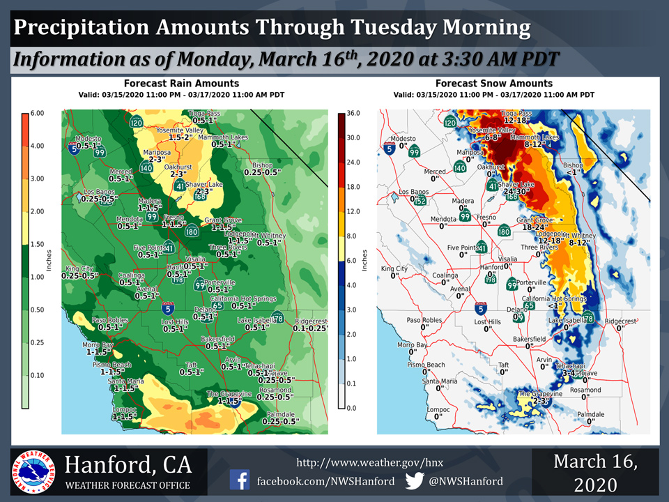
Projected rainfall totals through Tuesday for Mariposa: 2.00" to 3.00"
Projected rainfall totals through Tuesday for Oakhurst: 2.00" to 3.00"
Projected rainfall totals through Tuesday for Yosemite Valley: 1.50" to 2.00"
March 16, 2020 - The National Weather Service Hanford Office reports precipitation will increase across Central California today and tonight.
A Winter Storm Warning is in effect for the Southern Sierra Nevada above 4,000 feet and for the Kern County Mountains above 3,000 feet.
Accumulating snow is likely tonight and Tuesday morning at pass levels in Kern County, including Tejon Pass along Interstate 5 and Tehachapi Pass along Highway 58.
  Area Forecast Discussion
  National Weather Service Hanford CA
  337 AM PDT Mon Mar 16 2020

  .SYNOPSIS...
  Widespread precipitation will overspread Central California this
  morning. Significant mountain snow and valley rain is expected
  this afternoon and this evening. A few strong thunderstorms may
  develop this afternoon in all areas, except the Kern County
  desert. Precipitation should gradually diminish after midnight
  tonight into early Tuesday morning.

  &&

  .DISCUSSION...
  A potent low pressure system will move southward, just off the
  coast of California today through Tuesday morning. The heaviest
  precipitation associated with this low pressure system is expected
  this afternoon and this evening. Two to three inches of rain is
  possible in the Mariposa, Madera, and Fresno County foothills
  today and tonight, which may result in mudslides and rockslides.
  One to two inches of rain could fall in the Tulare County
  foothills today and tonight. In the San Joaquin Valley, rain
  amounts should generally be one half of an inch to an inch today
  and tonight. One quarter of an inch of rain to one half of an inch
  of rain may fall in the Kern County desert this afternoon and
  tonight. A few strong thunderstorms are possible this afternoon
  and this evening in most of the forecast area, with the exception
  being the Kern County desert. A Winter Storm Warning is in effect
  for the Southern Sierra Nevada and Kern County mountains.
  Snowfall of two to four inches is probable above 3000 feet on
  Interstate 5 and Highway 58 this evening and tonight. Travel
  delays and/or road closures are likely.

  A secondary atmospheric disturbance will develop in the
  northeastern quadrant of the aforementioned low pressure system
  Tuesday afternoon. This area of low pressure should be centered
  near the California/Nevada border Tuesday afternoon into Friday. A
  few strong thunderstorm are possible Tuesday afternoon in the
  western portions of Merced, Madera, Fresno, Kings, Tulare, and
  Kern Counties. A thunderstorm or two cannot be ruled out Wednesday
  afternoon, before atmospheric moisture associated with this low
  pressure system dissipates. Another storm system may impact
  Central California late this weekend or early next week.
Source: NWS

