


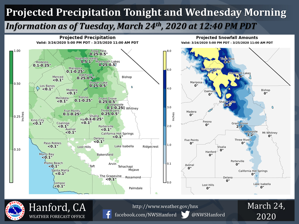
Projected rainfall totals for Mariposa: 0.10" to 0.25"
Projected rainfall totals for Oakhurst: 0.25" to 0.50"
Projected rainfall totals for Yosemite Valley: 0.50" to 1.00"
March 24, 2020 - The National Weather Service Hanford Office reports a light rainfall is possible in the San Joaquin Valley, mainly north of Kern County tonight and Wednesday morning.
Five to eight inches of snow is likely in the Mariposa and Madera portions of the Southern Sierra Nevada above 6,000 feet.
Three to five inches of snow is expected in the Mariposa, Madera, and northern Fresno County part of the Southern Sierra Nevada from 5,000 to 6,000 feet.
  Area Forecast Discussion
  National Weather Service Hanford CA
  150 PM PDT Tue Mar 24 2020


  .SYNOPSIS...Another storm system will bring more wet weather to
  the region through Thursday. Dry weather is expected Friday
  through the weekend, except for a slight chance of showers on
  Saturday for mainly the northern portions. Temperatures will be
  several degrees below normal through Friday then warming up to
  near normal this weekend.

  &&

  .DISCUSSION...Isolated to scattered showers will redevelop by
  later this afternoon and this evening. Otherwise, expect mostly
  cloudy skies and cooler than average temperatures to continue
  over much of our region. Most of the snow in the Sierra Nevada for
  tonight into Wednesday morning is expected above 5,000 feet from
  Yosemite southward to Fresno County where a Winter Weather
  Advisory remains in effect, as several inches of snow is expected
  with local amounts up to a foot possible. Rain amounts tonight
  into Wednesday will be relatively light, though could become
  moderate to heavy for brief periods.

  Per latest satellite images, trough continues to dig off the
  coast of Northern California at this time. Precipitation is
  expected to gradually shift southward by Wednesday afternoon and
  continue into Thursday. Showers and thunderstorms are possible for
  mainly north of Kern County in the San Joaquin Valley and the
  west side hills. As the trough digs further southward and the upper-
  level low passes into our portion of Central California, colder
  air will arrive by Wednesday night, as snow levels could lower to
  around 3,000 feet and possibly down to around 2,000 feet by
  Thursday morning. Expect mainly a dusting up to around two inches
  for these elevations, though snow amounts are more likely to be
  at the higher end of the range at the 3,000 foot level. It appears
  lighter amounts of snow will occur over the Kern County
  mountains, though there is still the possibility of some
  accumulating snow on the passes, such as the Grapevine and
  Tehachapi Pass (or up to an inch). Otherwise, expect most of the
  snow (generally several inches, though up to near one foot in some
  spots) in the Sierra Nevada during late Wednesday afternoon into
  early Thursday morning to fall above 4,000 feet in the Fresno and
  Tulare County portions of the Sierra Nevada for Wednesday
  afternoon into early Thursday morning where a Winter Weather
  Advisory will also be in effect. Rainfall amounts for Thursday
  will be generally light to moderate.

  A drier pattern is in store by Friday, but the morning may be
  quite chilly. Even Thursday morning will be much cooler than
  average, as lows are forecast to fall into the mid to upper 30s
  in the Central Valley on both mornings. It appears Friday morning
  will be slightly cooler, as skies will be clear. A drier period
  with a warming trend is expected this weekend into early next
  week, with the exception of a weak upper-level low passing over
  Northern California with an associated shortwave trough passing
  over Central California on Saturday afternoon and evening. Thus,
  have introduced some slight chance POPs for Merced County and
  eastward into the Sierra Nevada for this period. The shortwave
  may provide enough lift for showers in the Sierra as far south as
  Tulare County.

  More noticeable warming is in store for Sunday and afterward, and
  temperatures will return to seasonal averages to perhaps a few
  degrees above as high pressure ridging sets up. However, at this
  time, how warm temperatures reach remains to be seen, as the
  models show considerable differences in terms of strength of the
  ridging.
Source: NWS

