


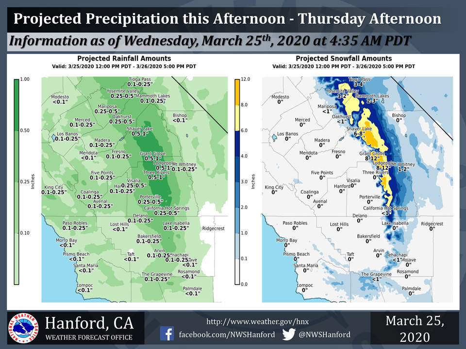
Projected rainfall totals for Mariposa: 0.25" to 0.50"
Projected rainfall totals for Oakhurst: 0.25" to 0.50"
Projected rainfall totals for Yosemite Valley: 0.25" to 0.50"
March 25, 2020 - The National Weather Service Hanford Office reports most of this projected precipitation will fall this afternoon and evening.
Rain amounts in the San Joaquin Valley will generally be one tenth of an inch to one quarter of an inch.
An inch or less of snow is possible along Interstate 5 and along Highway 58 above 4,000 feet this afternoon and evening.
  Area Forecast Discussion
  National Weather Service Hanford CA
  349 AM PDT Wed Mar 25 2020

  .SYNOPSIS...Another storm system will bring more wet weather to
  the region through Thursday. Dry weather is expected Friday
  through the weekend, except for a slight chance of showers on
  Saturday for mainly the northern portions. Temperatures will be
  several degrees below normal through Friday then warming up to
  near normal this weekend.

  &&

  .DISCUSSION...
  A digging cold trough of low pressure has pushed a surface cold
  front through the region. Precipitation has been generally light
  across the CENCAL interior. Cyclonic flow across the region will
  keep the chances of showers today and tomorrow. Scattered
  thunderstorms are expected today as an upper level impulse moves
  through the region. Small hail, locally heavy rain and possible
  cold air funnel clouds will be the threat today. Snow levels will
  drop very quickly as the colder air moves in. There is limited
  moisture with the system and unfortunately we will not see heavy
  snow amounts, even in the higher elevations. We have a winter
  weather advisory in effect for the Sierra.

  With cold air moving in over the area tonight we will see lows in
  the mid to upper 30s tonight and tomorrow night in the SJV.
  Showers will once again develop on Thursday as the upper trough
  kicks east. Weak ridging is expected for Friday with dry
  conditions. Models are still not in agreement with the strength
  of another trough forecast to move into the region on Sunday.
  Forecast confidence is low for the extended period with this
  system. The system will move east and the EPAC ridge will build in
  over the area with a warming trend in store early next week with
  significantly above normal temperatures.
Source: NWS

