


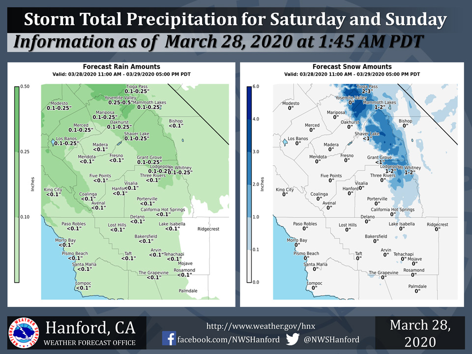
Projected rainfall totals for Mariposa: 0.10" to 0.25"
Projected rainfall totals for Oakhurst: 0.10" to 0.25"
Projected rainfall totals for Yosemite Valley: 0.25" to 0.50"
March 28, 2020 - The National Weather Service Hanford Office reports a weak storm system will move across Central California this weekend bringing a chance of light precipitation.
Rainfall in the San Joaquin Valley will generally be less than a tenth of an inch with amounts of a quarter to half an inch possible in the Sierra Nevada, mainly from Yosemite to Kings Canyon NP.
Snow amounts will generally be from 1 to 3 inches above 5000 feet, but isolated amounts up to 5 inches will be possible around Yosemite NP.
Area Forecast Discussion
National Weather Service Hanford CA.
219 AM PDT Sat Mar 28 2020
  .SYNOPSIS...
  A couple of weak disturbances will pass through the forecast area
  this weekend leading to light precipitation and cool afternoon
  temperatures. Dry pattern resumes next week as high pressure
  builds in the Eastern Pacific.

  &&

  .DISCUSSION...
  Current shortwave ridging over head will give way to an upper
  disturbance coming from the northern California Coast this
  afternoon. Afternoon high temperatures are forecast to be several
  degrees below normal this afternoon as cloud cover increases ahead
  of the incoming trough. Slight chance of light rain in the SJ
  Valley starting mid morning today and shifting southward
  throughout the afternoon. Light snow is possible in the Sierra
  Nevada mainly north of Camp Nelson beginning around noon today
  lasting through the night, with very light accumulations (1-2
  inches) above 5000 feet. Rainfall totals in the San Joaquin Valley
  will be nominal, with only a few hundredths of an inch expected.
  A second disturbance will impact Central California Sunday.
  Associated with the second ULL is another round of light precip,
  cool afternoon highs, and light snow in the Sierra Nevada through
  the afternoon. Snow levels will be in the 4500-5000 foot range
  Sunday, and snowfall totals in the Sierra Nevada again in the 1-2
  inch range. In Kern County there will be some gusty winds through
  and below the Kern County Mountain passes Sunday afternoon and
  evening as gradients increase.

  Pattern change will begin early next week as a ridge of high
  pressure builds in the Eastern Pacific. This will place much of
  California in dry, northwesterly flow through the rest of the
  forecast period. Monday and onwards we will be in a drier and
  warmer airmass, with afternoon highs Monday starting in the upper
  60s to near 70 degrees and trending upwards through the work
  week with highs near 80 by Thursday. Longer range models indicate
  that the dry and warmer pattern will persist into next weekend.
Source: NWS

