


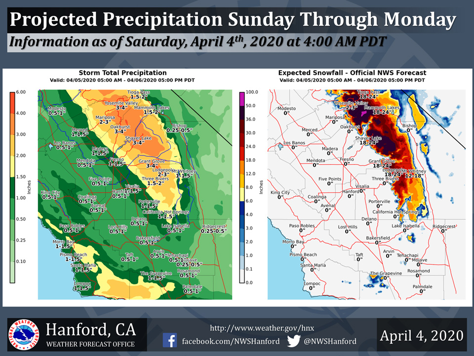
Projected rainfall totals for Mariposa: 2.00" to 3.00"
Projected rainfall totals for Oakhurst: 3.00" to 4.00"
Projected rainfall totals for Yosemite Valley: 3.00" to 4.00"
April 4, 2020 - The National Weather Service Hanford Office reports a significant storm system will impact Central California Sunday through Monday.
A Winter Storm Warning is in effect for the Southern Sierra Nevada above 4,500 feet Sunday morning through Monday afternoon.
The majority of this precipitation will fall Sunday afternoon and Sunday night.
  National Weather Service Hanford CA
  416 AM PDT Sat Apr 4 2020


  .SYNOPSIS...
  A storm system will bring unsettled weather this weekend and
  through early next week, with heavy mountain snow and appreciable
  valley rain on tap for Sunday and Monday. Dry and warming
  conditions will return for the latter half of the week.

  &&

  .DISCUSSION...
  It`s a seasonably cool morning across central California under
  mostly clear skies as a west to northwest flow prevails across the
  region. Satellite and radar loops show a low pressure system and
  associated precipitation swinging into the northern California
  coast. This system will impact our weather beginning today as it
  continues to push inland.

  Models spread precipitation southward today, affecting northern
  portions of our area by this afternoon. The system and more
  significant precipitation will pass mainly to our north and we
  should see just light rain and higher elevation snow today,
  remaining generally north of Kern County.

  A deeper developing low pressure system dropping out of the
  northwest Pacific behind this initial disturbance is progged with
  good model agreement to drop slowly southward off the California
  coast by early Sunday through Monday. This system will bring more
  significant precipitation to our area by late tonight/early
  Sunday morning. The heavier precip will continue into Monday
  with the slow southerly drift of the system. Total snowfall
  accumulations Sunday through Monday will be as much as 2 to 3 feet
  in higher elevations of the Sierra and around a foot as low as
  4500 feet. A Winter Storm Warning has been issued for much of our
  Sierra zones for Sunday morning through Monday afternoon.

  Model solutions are not too dissimilar in timing and trajectory
  as the system swings inland near southern California Tuesday into
  Wednesday. This will keep unsettled conditions over much of our
  area into the middle of next week, with a few showers lingering
  over the mountains into Thursday as the system pushes off to the
  east. High pressure building in behind the departing low pressure
  system will will bring a warming and drying trend for the end of
  the week.
Source: NWS

