


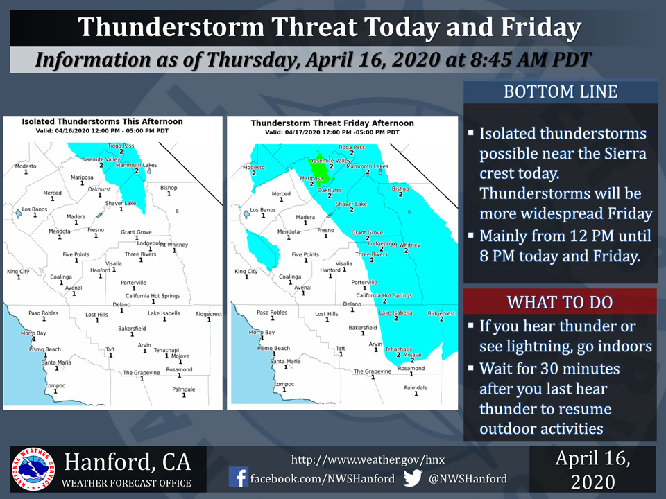
April 16, 2020 - The National Weather Service Hanford Office reports isolated thunderstorms are possible near the Sierra crest this afternoon, mainly from Fresno County northward.
The threat of afternoon thunderstorms will extend westward into the Sierra foothills Friday and also include the West Side Hills.
In addition to dangerous lightning, thunderstorms can bring briefly heavy rain and locally strong, gusty winds.
When thunder roars, seek shelter indoors!
  Area Forecast Discussion
  National Weather Service Hanford CA
  415 AM PDT Thu Apr 16 2020


  .SYNOPSIS...
  Dry weather and above normal temperatures can be expected over
  the central California interior through Thursday. A storm system
  will bring precipitation into the mountains Thursday afternoon
  then across much of the district Friday into Friday evening along
  with much cooler temperatures. Showers could linger over the
  Sierra Saturday. Dry weather will return Sunday before another
  storm brings showers back into the district early next week.

  &&

  .DISCUSSION...
  Satellite images show increasing mid and upper level moisture
  moving into central California due to a west flow aloft. In
  addition a closed upper trough off the north California coast will
  move southward reaching the central coast late this afternoon.
  Higher resolution models show increasing instability over the high
  sierra late this afternoon. Convective storms could develop late
  in the afternoon driven mainly by day time heating as the trough
  may be too far offshore to provide any synoptic forcing. Storms
  should be isolated but the southern sierra will be in a col area.
  This will result in light steering wind so storms may remain near
  stationary providing locally heavy rain. The trough will push
  towards Cape Conception tonight and onshore through southern CA
  Friday. Showers could develop in the San Joaquin Valley tonight as
  the SJ valley will be in a favorable area of upper level
  divergence in the NE quadrant of the low. The central CA interior
  will be in between weather systems as another disturbance moves
  off the north CA coast on Friday. Models show the potential for
  convective showers to be more widespread over the sierra. Mid
  level steering winds will be light again with slow moving storms
  will increase the potential for locally heavy downpours with any
  storm. Average precipitation totals from this system should be
  rather light, ranging from less than a tenth of an inch in the San
  Joaquin Valley and the Kern county desert to a quarter to a third
  of an inch in the mountains. Up to four inches of new snow could
  fall in the Sierra above 8000 feet by Friday evening as the storm
  exits towards Arizona. The upper level trough in NCa will move SE
  into central California early this weekend and could rejuvenate
  additional showers over the foothills and higher elevations of the
  Sierra Saturday afternoon. Otherwise, high temperatures will be
  much cooler and closer to normal Friday and Saturday.

  Dry weather should return to the district Saturday night and
  continue through Sunday due to short wave ridging aloft.
  A colder storm system could bring more widespread precipitation
  across the district early next week. However medium range models
  remain in poor agreement with the timing of this system. The GFS
  is more progressive and brings it across CA Monday while the EC
  closes the low off NCa coast and onshore over CA on Tuesday. Thus
  confidence in the extended for early next week is low. A prolonged
  stretch of dry weather may follow this weather system starting
  next Wednesday as a high amplitude ridge of high pressure builds
  in from the eastern Pacific.
Source: NWS

