


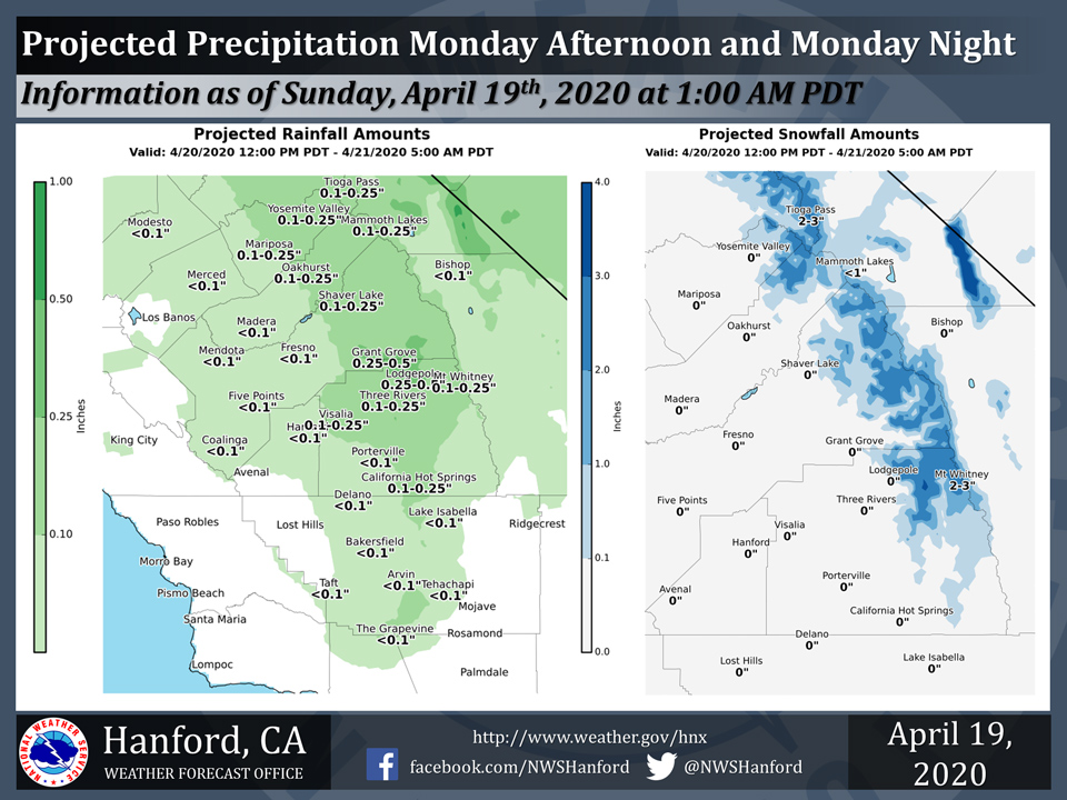
Projected rainfall totals for Mariposa: 0.10" to 0.25"
Projected rainfall totals for Oakhurst: 0.10" to 0.25"
Projected rainfall totals for Yosemite Valley: 0.10" to 0.25"
April 19, 2020 - The National Weather Service Hanford Office reports a rather weak storm system will impact Central California Monday afternoon and Monday night.
Two to four inches of snow is possible in the Southern Sierra Nevada above 7,000 feet.
The majority of this precipitation will fall Monday afternoon and Monday evening.
  Area Forecast Discussion
  National Weather Service Hanford CA
  138 AM PDT Sun Apr 19 2020


  .SYNOPSIS...Dry weather with seasonal temperatures will prevail
  today. The next storm system is expected to impact Central
  California Monday and will bring a chance of showers with a few
  mountain thunderstorms Monday afternoon and evening. Some mountain
  showers could linger on Monday night into Tuesday. Otherwise, dry
  weather along with a warming trend are expected Wednesday through
  next weekend.

  &&

  .DISCUSSION...Mainly seasonal temperatures and dry conditions will
  prevail today before the next low pressure system arrives on
  Monday. Low cloud cover persists over the Sierra Nevada and east
  side of the San Joaquin Valley at this time, although this will
  likely clear later this morning. Some breezy conditions are
  possible in the Kern County desert by this evening, although we
  are not expecting Wind Advisory criteria at this time. Daytime
  high temperatures on Monday will likely lower to a few degrees
  lower than today`s as a shortwave trough ahead of an upper-level
  low that will eventually pass into the region. This trough will
  provide enough lift for a good chance of showers over the mountain
  areas, and isolated thunderstorms are possible over portions of
  the Sierra Nevada. In addition, snow levels will be relatively
  high for this system, or mainly around 7,000 feet. A slight
  chance of showers is mentioned elsewhere, including into the
  Central Valley. The upper-level low will move southeastward over
  our forecast area during Monday night into Tuesday morning, so low
  clouds and showers due to upslope flow will likely continue at
  least in the Kern County mountain areas and in parts of the southern
  Sierra Nevada. The upper low will move over S NV/NW AZ by Tuesday
  afternoon, so clouds and precipitation should clear over these
  mountain areas.

  By the middle of the week, temperatures are projected to rise back
  to above average and continue to warm through next weekend. The
  upper-level ridge will build along the coast and gradually shift
  inland over the next several days, so this will likely produce the
  warming trend. The warmest temperatures of this year so far are
  possible by Saturday, as the warmest locations in the San Joaquin
  Valley and the Kern County desert may reach highs in the upper
  80s to near 90 degrees. Much of our portion of Central California
  will likely reach high temperatures of 10 to 15 degrees above
  seasonal averages. There is the potential for warm temperatures
  and dry conditions to continue into next week.
Source: NWS

