


California and National Drought Summary for May 12, 2020
Summary
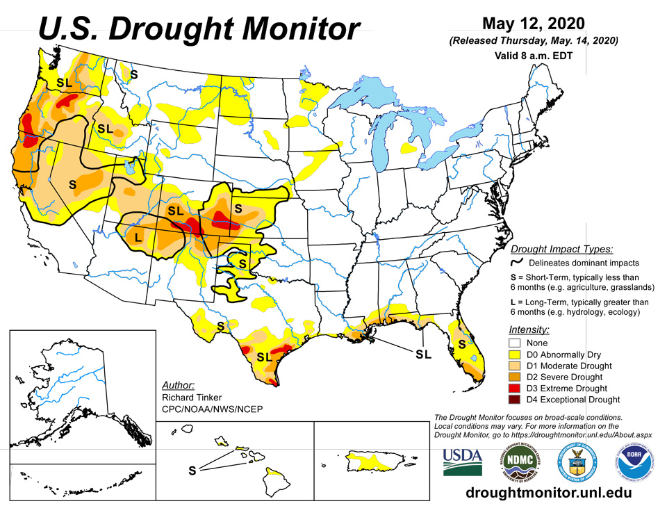
May 14, 2020 - Light precipitation at best covered most of the 48 states, so drought deterioration was more common than improvement this past week. Less than half an inch fell on most areas across the Southeast, Great Lakes Region, central and northern Plains, Mississippi Valley, Texas, and from the Rockies to the Pacific Coast. Widespread light to moderate precipitation covered the Northeast and the central Appalachians, and a fairly broad area centered along the Ohio Valley received from a few tenths to one-half inch. Farther west, there were a few exceptions to the generally dry week. More than 2 inches of rain soaked parts of the south-central Great Plains and adjacent western Mississippi Valley, western Deep South Texas, and central Montana. The broadest area of heavy precipitation covered a solid swath from south-central Kansas through southern Missouri, where totals ranged from 2 to nearly 4 inches. Similar amounts were more scattered in a stripe from southern Oklahoma and northeastern Texas through southern Louisiana, as well as in central Montana. Isolated sites in southwestern Texas were soaked by as much as 6 inches of rain, but closer to 2 inches fell on most locales there. Elsewhere, there were a few areas of moderate to precipitation from the northern High Plains into central Montana, and in orographically-favored parts of the northern Cascades.
Northeast
A week of near normal precipitation kept moisture deficits at bay. For the past few months, surplus precipitation has prevailed, and no areas of dryness or drought were identified.
Southeast
Despite the dry week, most of the Southeast maintained the precipitation surpluses observed on time scales ranging from 30 days to a couple years, especially across the interior. Closer to the coast, conditions are markedly different. Drought is limited in coverage, but entrenched and severe in many areas where it exists. Conditions were effectively unchanged across the Florida Peninsula. Most areas there are nominally dry, but drought has enveloped central and eastern parts of the upper Peninsula, and much of the lower Peninsula. An area of severe D2 drought has settled near the southwestern coast, where the last 90 days brought only 10 to 25 percent of normal rainfall.
Dry conditions are also established along the central Gulf Coast region, extending into southern Alabama. Moderate drought expanded eastward near the coastal areas, stretching to near the Peninsula, while severe drought (D2) pushed slightly northward in the Alabama Panhandle and southernmost Mississippi. Rainfall since mid-February has totaled 8 to 12 inches below normal in the D2 areas, and wildfires are dotting the westernmost section of Florida.
South
Similar to conditions in the Southeast, surplus rainfall has prevailed across the interior, but dryness and drought are entrenched along most of the Gulf Coast, and across southern Texas. Less extreme dryness covers part of central Texas, western Oklahoma and adjacent Texas, and the lower Big Bend. D0 prevails across these regions, with only scattered patches of moderate drought. In contrast, extreme D3 drought has developed in a few regions across southern Texas, primarily near the Gulf of Mexico and along the Rio Grande, while severe drought is impacting a large part of southeastern Texas and smaller areas near the Mexican Border. A small area of intense rainfall – up to 5 inches in spots – brought relief to western Deep South Texas, with the wettest areas improving from severe D2 drought to abnormal dryness (D0). Areas of severe to extreme drought recorded less than half of normal rainfall for the past 90 days, with rainfall deficits of 5 to 7 inches observed southeast of Victoria.
Midwest
This regions remains free of drought, with persistently above-normal precipitation prevailing for over a year in some areas. Still, a few small areas of abnormal dryness have developed. One in east-central Michigan grew slightly this past week, and a small area of D0 pushed into west-central Wisconsin from the broader-scale dryness farther west.
High Plains
Drought is intensifying quickly across the southern tier of this region from southern Colorado through western Kansas. Severe D2 drought is now extant throughout this area, and extreme D3 drought envelops much of southern Colorado and adjacent southwestern Kansas. Most of this region has recorded less than an inch of precipitation during the past 3 months, and at best a few tenths of an inch have fallen mid-March. Abnormally warm weather is exacerbating the acute dryness. The past 3 months have averaged 2 to 4 degrees F above normal, and since late April, averages have been 7 to 9 degrees F above normal. Farther north and east, many areas fell into abnormal dryness this past week as precipitation deficits continued to slowly accumulate. Many areas have seen precipitation totals among the driest 5 percent of historical occurrences for the last 30 days, or 90 days, or both. D0 was introduced where the dryness has been most acute for 1 to 3 months, specifically southeastern Nebraska, a swath from southwest to north-central Iowa, part of eastern South Dakota, southeastern Minnesota, and a large area across central and northern Minnesota. Precipitation has been sharply below normal for at least a few weeks, but impacts have been limited so far. Water supplies, agriculture, and soil moisture have been minimally affected, so the assessment is less intense than most precipitation statistics would imply. At some point, conditions could deteriorate rapidly if these trends continue, so this region must be monitored closely as we move into the growing season.
Farther west, northwest South Dakota and surrounds was one of very few areas to improve this past week, along with part of north-central North Dakota. Generally 2 to 4 inches of precipitations moistened up these regions in the last 2 weeks, eliminating D0 in northwestern South Dakota and adjacent areas.
Precipitation has not been as generous across northern Wyoming, with D0 stretching into northeastern parts of the state, and adjacent Montana. Precipitation among the driest 10% on record was observed in the new D0 areas over the last 4 months. On the other end of the state, abnormal dryness was also introduced in southwestern Wyoming adjacent to Utah.
West
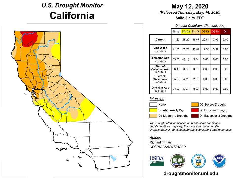
Central Montana was another of the few areas that improved this week, with 1.5 to 3.0 inches of precipitation bringing relief from recent dryness. Other parts of the state missed the beneficial moisture, and precipitation totals among the lowest 5 to 20 percent on record since early February in southwest Montana, prompting D0 expansion into the region. Farther south and west, dryness and warmth led to deterioration in much of Nevada, Oregon, small parts of Washington, and the western Idaho Panhandle. Most notably, extreme dryness stretched southward in central Nevada, moderate drought enveloped much of northwestern Nevada and adjacent Oregon, moderate drought covered the central Sierra Nevada, and extreme D3 drought expanded in north-central Oregon with a general 1-category deterioration introduced farther east. There were some spots where drought eased – significantly, D3 was improved to D2 in north-central California – but the dry and warm week led to much larger areas of intensification. Snowmelt continued at a rapid pace as temperatures in many areas across the West averaged 2 to 5 degrees F above normal for the past 3 months, and 5 to 10 degrees F for the past 2 weeks.
Alaska, Hawaii, and Puerto Rico
Alaska remained drought free. Rainfall deficiencies have slowly increased across the leeward areas of Hawaii, as well as the northeastern Big Island, prompting a large expansion of D0 across these areas, with a few small areas on the west side of some islands slipping into moderate drought. Most of central and northwestern Puerto Rico endured another dry week, leading to a significant northward and northwestward expansion of abnormal dryness. Lake Guajataca in the interior northwest has dropped significantly over the past several months, reaching a level triggering “operational adjustment” and an enhanced encouragement of water conservation.
Pacific Islands
The weather conditions across the U.S.-Affiliated Pacific Islands (USAPI) during this USDM week (5/6/20-5/12/20) consisted of trade-wind convergence with an Inter-Tropical Convergence Zone (ITCZ) over eastern Micronesia, a near-equatorial trough with embedded weak circulations over western Micronesia, a dry trade-wind regime across the Marianas, and a dry and stable air mass over American Samoa. One of the circulations developed into Tropical Depression 01W west of Palau at the end of the week, strengthening into Tropical Storm VongFong on May 13. A weak trade-wind disturbance near the end of the week gave Guam 2 inches of rain but missed the rest of the Mariana island chain. An upper-level trough, with its strong upper-level divergence, enhanced showers over parts of the Marshall Islands (RMI) at week's end. Marginally unstable air at mid-week briefly brought scattered showers to American Samoa.
Satellite-based estimates of 7-day precipitation (QPE) showed the climatological ITCZ stretching from Indonesia eastward across the equatorial Pacific, between roughly 2 and 10 degrees N latitude, and the South Pacific Convergence Zone (SPCZ) extending from Indonesia southeastward. A band of 2+ inches of rain stretched across Micronesia with embedded 4+ inch areas. The main band tapered to 1 inch or less to the north and south, extending to the equator and as far north as Guam over the Federated States of Micronesia (FSM). The QPE showed northwest to southeast bands of 1+ inches of rain bracketing the Samoan Islands, with very little rainfall depicted by the satellite QPE over American Samoa.
With the exception of Peleliu, across-the-board rainfall totals in Palau so far in May have already exceeded the 8-inch minimum criterion considered to meet most water needs. The heavy rainfall totals were largely due to two tropical disturbances; Invest 94W to the northwest of Palau on May 1, and Invest 95W to the southeast of Palau on May 8-10 (which would later become Tropical Storm VongFong). Rain gauges across the main islands of the Republic of Palau measured 8.02 inches (WSO Palau), 4.90 inches (Aimeliik), 4.55 inches (Koror), 2.94 inches (Melekeok), and 0.23-inch (Peleliu) on May 1, associated with the first disturbance. For the May 1-11 period, WSO Palau (Ikoranges, Airai Airport) measured 15.88 inches of rain, Koror (Ngerbeched) 14.69 inches, Aimeliik (Nekken Forestry) 10.28 inches, Melekeok (Ngerubesang) 10.05 inches, and Peleliu (Kloulklubed) 2.85 inches. A sharp gradient in precipitation amounts was noted in southern Palau, with excessive amounts in Koror, and comparatively little rain in Peleliu. For the May 1-11 period, WSO Palau's rainfall total stands at 112 percent of normal (normal is 14.15 inches), and Koror's accumulation stands at 117 percent of normal (normal is 12.52 inches). Historical rainfall records show the highest monthly rainfall (for May) at Airai Airport was 22.71 inches in 2005, and at Koror was 27.46 inches in 1954. It remains to be seen whether or not this May's rainfall total will set a new record. Significant impacts include flood-prone road damage within the states of Aimeliik, Airai, and Koror. This includes the formation of new potholes, damage to existing potholes, and damage to incomplete road works. This week, the Palau International Airport (IAP) received 5.21 inches of rain, and the Koror COOP received a similar total of 4.89 inches (1 day missing). Palau remains drought-free this week, after being improved from D0 to drought-free conditions last week.
Guam received 2.18 inches of rain this week, which is more than double the weekly rainfall minimum needed (1-inch) to meet most water needs. As noted earlier in the satellite QPE paragraph, Guam was on the northern periphery of the main heavy rain band, but unfortunately very little rainfall made it to the hard-hit areas of Saipan, Tinian, and Rota. Guam's drought designation remains at D1 (moderate drought). Very dry weather continues across the Commonwealth of the Northern Mariana Islands (CNMI) this week. Rainfall reports at several locations within Saipan include only 0.08-inch at a National Park Service site, 0.02-inch from a manual gauge, and 0.02-inch at the Saipan ASOS location. Rota reported a meager 0.01-inch this week, and Tinian reported 0.23-inch (1 day missing). The drought designations for Saipan and Rota remain at D3(SL) and D3(S) this week (extreme drought), respectively.
Within the Federated States of Micronesia (FSM), heavy precipitation this week supported one-category drought improvements for a few locations. These included Yap with 4.53 inches (upgraded from D3 to D2 this week), Ulithi with 4.67 inches (upgraded from D2 to D1 this week), and Woleai with 3.23 inches (upgraded from D2 to D1 this week). This week marks the second consecutive week with more-than-adequate rainfall to meet most water needs at Yap and Woleai. Rainfall data from Fananu was unavailable, preventing the inclusion of this station into the analysis this week. North Fanif received 5.34 inches of rain this week and Chuuk Lagoon reported 1.74 inches. No change was made to Chuuk's drought designation of D0 (abnormal dryness). The six remaining stations within the FSM continue to be drought-free, having received plenty of rain at weekly and monthly timescales. These stations and their weekly rainfall totals for this drought week (May 6-12, 2020) are Lukunor (4.86 inches), Nukuoro (1.46 inches), Kapingamarangi (0.83-inch), Pohnpei (4.48 inches), Pingelap (2.80 inches, 3 days missing), and Kosrae (5.94 inches). The last 7 weeks have been wet at Kosrae, as have the past 12 months! April's total rainfall of 29.87 inches is 153 percent of normal. Of the 52 April's on record, only three were wetter than this past April (percentile is 0.942).
In the Republic of the Marshall Islands (RMI), nearly all stations exceeded the weekly minimum threshold required to meet most water needs (2 inches). This included Mili (5.37 inches), Majuro (3.40 inches), Ailinglapalap (3.10 inches), Kwajalein (2.54 inches), Wotje (2.20 inches, 1 day missing), and Jaluit (2.16 inches). The only station that received less rainfall than is considered enough to meet most water needs was Utirik with 0.36-inch of rain (4 days missing). Recent rainfall and decent increases in water catchment levels on Kwajalein supported a one-category improvement in the drought designation from D2 to D1 this week. None of the other designations within the RMI were changed this week. One station that may need a designation upgrade soon is Majuro (currently D0). As of May 12, Majuro reservoir storage capacity stood at 29.4 million gallons, which is about 81.7 percent of its total capacity of 36 million gallons (or 136.3 million liters).
Although northwest-to-southeast oriented bands of 1+ inch rains bracketed American Samoa this week, marginally unstable air at mid-week allowed for the development of some shower activity. Rainfall measurements taken across American Samoa showed 1.19 inches of rain had fallen at Pago Pago, 1.00-inch at Siufaga Ridge, and 0.94-inch at Toa Ridge. These last two locations are automated stations within the National Park Service. No change was deemed necessary to Tutuila's drought-free status this week in American Samoa.
Virgin Islands
At the Cyril E. King Airport in St. Thomas, a trace of precipitation was reported so far this month. Since March 1, 3.52 inches of rain have fallen, resulting in a deficit of 1.94 inches for the period. The Year-To-Date (YTD) accumulation at the King Airport is 8.47 inches of rain. Given the normal for the YTD period is 9.27 inches, the result is a shortfall of 0.80-inch of rain. Airport climate records (for both St. Thomas and St. Croix) indicate seasonal shower activity normally ramps up in May. Anna's Retreat (CoCoRaHS VI-ST-1) recorded 0.08-inch of rain this drought week (May 6-12). The Grade School 3 USGS well (Charlotte Amalie, St. Thomas) has a (provisional) current water level that is nearly 12 feet below the land surface. SPI values at 1,3,6,9, and 12 months for Charlotte Amalie are (respectively): -1.33, -0.41, -0.28, -0.55, and +0.01. Although recent conditions on St. Thomas have been dry, the drought designation remains (at least for now) at D0(S) or abnormal dryness.
A volunteer observer at Windswept Beach, St. John, reported 0.77-inch of rainfall during April. For this location, 1984-2019 climatology indicates mean rainfall increases from 1.73 inches in March to 2.81 inches in April, to 4.52 inches in May. For this drought week, 0.18-inch of rain was measured on Windswept Beach, continuing the relative dryness of the past 1-2 months. On the western part of St. John, the Susannaberg DPW 3 well currently registers a water level that is approaching 15 feet below the land surface, continuing its steady decline from about the start of February 2020, when the water depth was just over 8 feet below the land surface. As was the case for St. Thomas, the drought designation for St. John remains (at least for now) at D0(S).
The Henry E. Rohlsen Airport in St. Croix picked up 0.15-inch of rain on May 12. This brings the month-to-date accumulation to 0.49-inch of rain since the beginning of May. Since March 1, 4.86 inches of rain was reported, which resulted in a deficit of 0.40-inch. The YTD rainfall total is 8.61 inches. A normal rainfall total of 9.05 inches for the YTD period results in a deficit of 0.44-inch. Two locations in Christiansted (CoCoRaHS VI-SC-8 and VI-SC-9) have measured 0.39-inch and 0.23-inch of rain this week, respectively. The Adventure 28 Well on St. Croix continues to indicate a water level depth that has varied between 19.5-20.5 feet below the land surface since the end of February. SPI values at 1,3,6,9, and 12 months for Christiansted are (respectively): -1.28, -0.09, -0.71, -1.78, and -1.03. Dry weather prevailed at the UVI sheep research facility on St. Croix (17.7160N, 64.7958W) until late in the drought-monitoring period, when a third of an inch of rain fell. A little more rain (0.11-inch) fell on May 12-13. The drought designation remains at D0(SL) for now at St. Croix, but like the other islands, there will likely be a degradation in category next week provided there are no significant changes in the weather pattern.
Looking Ahead
During May 14-18, 2020 a broad swath of heavy rain is expected from south Texas northeastward across Missouri, the northern Ohio Valley, the Northeast, and lower New England. Forecasts show a broad, unbroken stripe through this region where more than 1.75 inches of precipitation is expected. Within this stripe, some areas are expecting very heavy precipitation. Most notably, central to south Texas is expecting 3 to locally 5 inches of rain. A few smaller patches are expected to get 3 to maybe 4 inches of rain, including northeast Oklahoma and southeast Kansas, part of north-central Illinois, and northwestern Pennsylvania and adjacent Ohio to near Cleveland. Outside this stripe, precipitation will drop off dramatically. From the Carolinas through Alabama and into central Florida, almost no rain is anticipated. Likewise, precipitation should be lacking from the Great Basin and southern California through most of the Four Corners States. Elsewhere, moderate to heavy precipitation is expected in orographically-favored areas near the Sierra Nevada and Cascades, and in south Florida (especially along the southeastern coastline). Light to moderate precipitation, with totals approaching an inch in a few patches, are expected from the upper Mississippi through the north half of the High Plains to the Pacific Northwest. Most of the 48 states will stay warmer than normal at night, save for upper New England. But temperatures should remain unusually low during the day across the Great Lakes into the northern Plains, and from central California through the Pacific Northwest. Other areas should average a few degrees above normal at night, and near normal during the day.
For the ensuing 5 days, drier than normal conditions are favored from roughly from the Mississippi Valley through the Atlantic Seaboard, and to a lesser extent in parts of the central Rockies and surrounds. There are enhanced chances for surplus precipitation across most of Texas into central New Nexico, across the northern tier of states from the Plains westward, and over the Great Basin and nearby California. Meanwhile, in most locales from the Plains (outside south Texas) eastward across the Mississippi Valley to the Appalachians, odds favor above-normal temperatures. Farther west, subnormal temperatures are favored from the western Rockies to the Pacific Coast
Author(s):
Richard Tinker, NOAA/NWS/NCEP/CPC
Anthony Artusa, NOAA/NWS/NCEP/CPC
Dryness Categories
D0 Abnormally Dry—used for areas showing dryness but not yet in drought, or for areas recovering from drought.
Drought Intensity Categories
D1 Moderate Drought
D2 Severe Drought
D3 Extreme Drought
D4 Exceptional Drought
Drought or Dryness Types
S Short-Term, typically less than 6 months (e.g. agricultural, grasslands)
L Long-Term, typically greater than 6 months (e.g. hydrologic, ecologic)
Source: National Drought Mitigation Center

