


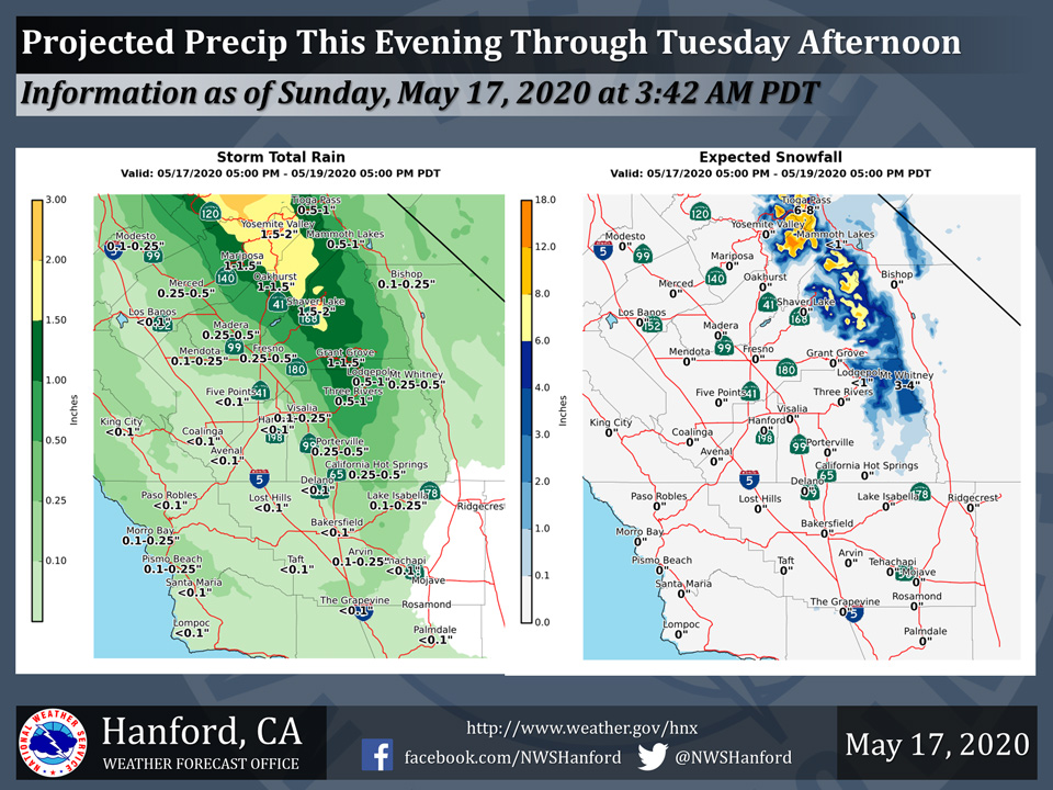
Projected rainfall totals for Mariposa: 1.00" to 1.50"
Projected rainfall totals for Oakhurst: 1.00" to 1.50"
Projected rainfall totals for Yosemite Valley: 1.50" to 2.00"
May 17, 2020 - The National Weather Service Hanford Office reports a storm system will impact Central California this evening through Tuesday afternoon.
Snow levels will start at around 9,000 feet Sunday evening.
Snow levels will gradually lower, reaching 6,500 feet by Tuesday.
The majority of this precipitation will fall Monday.
Area Forecast Discussion
National Weather Service Hanford CA
411 AM PDT Sun May 17 2020
  .SYNOPSIS...
  Dry weather will continue through this afternoon, then a Pacific
  storm system will spread precipitation across the area from this
  evening through Tuesday. Periods of breezy to windy conditions
  are expected over the next several days, especially in the wind
  prone areas. Thunderstorms will be possible Monday and Tuesday.
  Near normal temperatures today will fall to well below normal
  Monday and Tuesday, but then trend warmer later in the week.

  &&

  .DISCUSSION...
  The upper ridge that brought us warm and dry conditions yesterday
  has now shifted east with the axis over the Four Corners region.
  This puts us on the warm side of the ridge under a southwest flow
  aloft. So despite some cloud cover today, we should see similar
  temperatures to Saturday, with highs at to slightly above normal.
  But a Pacific storms system will begin to impact the district by
  this evening with much cooler and unsettled conditions continuing
  through Tuesday.

  A ~540 DM upper low is spinning off the Pacific Northwest coast
  this morning and there is a 1.3" PWAT moisture plume extending
  offshore from the SF Bay area. The upper low will slowly shift
  southeast today, driving a cold front down through California.
  Precipitation may begin as early as this afternoon around Yosemite
  NP, but will really ramp up tonight as the front moves in. The
  combination of the rich moisture plume and enhanced orographic
  lift in the southwest flow aloft, should result in some healthy
  precipitation amounts across the Sierra. The low is progged to be
  over the northern California coast on Monday afternoon. This will
  create a more unstable air mass and there could be some isolated
  afternoon thunderstorms north of Fresno County. By Tuesday, the
  low shifts over northwest Nevada which will extend the unstable
  conditions farther south. Thunderstorm chances look to mainly be
  over the Sierra on Tuesday. Precipitation amounts will be quite
  variable. Rain shadowing will limit rainfall on the west side of
  the Valley with some areas likely seeing only a few hundredths of
  an inch. The east side of the Valley could see a quarter to one
  half of an inch. The Sierra Nevada could see some significant
  totals; from around 1.5" in Yosemite NP to 1" in Kings Canyon NP.
  Lesser amounts are expected as you go south with only a tenth to
  one quarter of an inch in the Kern County Mountains. The Desert in
  Kern County may not see much rain at all due to shadowing effects.
  The snow level will start out around 10,000 feet tonight the lower
  to 7,000 feet on Monday. A Winter Storm Warning is in effect for
  the Sierra above 7,000 feet from Yosemite to Kings Canyon NP from
  6 PM this evening until 4 PM Tuesday. Total accumulations of 6-12
  inches are expected with isolated amounts up to 15 inches possible.
  A Winter Weather Advisory is in effect for the Sierra above 7,000
  feet from Sequoia NP to the Tulare/Kern County line. Total snow
  accumulations up to 4 inches will be possible. A few showers may
  develop around Yosemite on Wednesday, but little impact expected.
  Periods of gusty winds will occur the next few days as well.

  Temperatures will go from near normal today to well below normal
  Monday and Tuesday. Forecast highs on those days are generally
  around 12-18 degrees below climatological normals. Temperatures
  rebound quickly this time of the year and we expect highs to be
  back near normal by Thursday. Another upper trough may brush the
  region on Friday and nudge temps back down a bit. An upper ridge
  is progged to build in next weekend for seasonable temperatures
  and dry weather.
Source: NWS

