


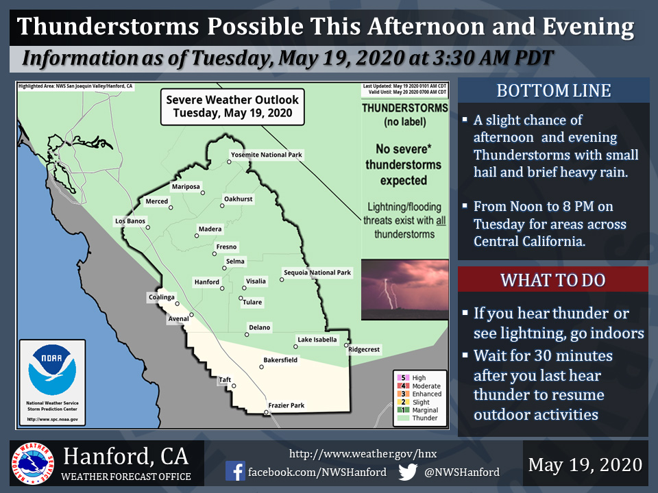
Possible Thunderstorms Today for Mariposa, Oakhurst and Yosemite National Park
May 19, 2020 - The National Weather Service reports a few strong thunderstorms are possible across Central California this Tuesday afternoon and evening.
Small hail, brief heavy rain and wind gusts near 45 miles per hour are some of the hazards associated with strong thunderstorms.
In addition to dangerous cloud to ground lightning strikes, any thunderstorm can produce localized flooding and possibly generate a funnel cloud.
  Area Forecast Discussion
  National Weather Service Hanford CA
  402 AM PDT Tue May 19 2020

  .SYNOPSIS...
  A storm system will exit into the Great Basin today but continue
  to bring showers over the mountains into early this evening. There
  is a slight chance of mainly afternoon thunderstorms over much of
  the district today as well. Dry weather is expected tonight and
  during the next several days. Temperatures will remain much cooler
  than normal through Wednesday, then recover to seasonable levels
  Thursday and Friday. A major warming trend will begin this weekend
  and continue into early next week. High temperatures will be in
  the 90s in the San Joaquin Valley and desert by Sunday.

  &&

  .DISCUSSION...Judging by water vapor imagery, the cold core low
  appears to currently be centered over the San Francisco Bay area.
  Radar shows numerous showers continuing over the mountains from
  Fresno County to Kern County. Mesonet data suggests that snow
  levels are generally above 7,000 feet but could be as lows as 6,000
  feet in heavier showers. A few showers are still being detected on
  radar over the southernmost San Joaquin Valley at this time.
  Otherwise, the remainder of the central California interior is
  absent of showers and northwesterly winds have diminished
  considerably since Monday afternoon. The bulk of accumulating snow
  over the high Sierra is just about over, so will let the Winter
  Weather products expire at 5 am.  Additional snow showers in the
  mountains today will bring at most a couple of inches in some
  locations above 7,000 feet.

  During the next several hours, the upper level low will drift
  eastward and should exit east of our CWA this afternoon. Although
  the upper atmosphere will begin to warm a bit by then, it will
  still be very cold aloft (-20C or colder at 500 mb), so as the
  mid May sun heats up the lower levels of the atmosphere, we`re
  likely to see isolated thunderstorms popping up again this
  afternoon. Otherwise, cloudy skies and showery weather will
  continue over the mountains into this evening. A prevailing
  northwesterly flow in the wake of this storm system will keep
  clouds banked up along the west slopes of the Sierra and the
  north facing slopes of the Tehachapi mountains tonight into
  Wednesday morning. The presence of a 100-knot jet over the CWA
  will support brisk northwest winds over the western half of the
  San Joaquin Valley Wednesday afternoon with gusts of up to 30 mph
  possible in a few locations along the I-5 corridor. Isolated
  afternoon showers could develop near the Sierra crest as well.
  Otherwise, dry weather should be the rule Wednesday with high
  temperatures remaining several degrees below normal.

  The models build an upper level ridge of high pressure into
  central California Wednesday night and Thursday. A weak upper
  level trough will flatten this ridge over central California
  Friday as the trough tracks eastward through the Pacific
  Northwest. Moisture and dynamics associated with this trough
  will be too far north to bring any more than some mid and high
  clouds to the central California interior later this week.
  However, the trough will stave our warming trend for a couple
  of days once high temperatures finally recover to seasonable
  levels Thursday.

  Sunday will mark the beginning of a major warm up over the
  CWA as a strong upper level ridge of high pressure builds over
  the Golden State. High temperatures of 90 degrees or higher
  can be expected in the San Joaquin Valley, lower foothills and
  the Kern County desert Sunday. Afternoon temperatures will
  be well into the 90s in these areas by Memorial Day. In the
  hottest locations, thermometer readings could top the century
  mark, especially one week from today. So enjoy this cool change
  in the weather. We may not see it again until late Autumn.
Source: NWS

