


California and National Drought Summary for June 2, 2020
Summary
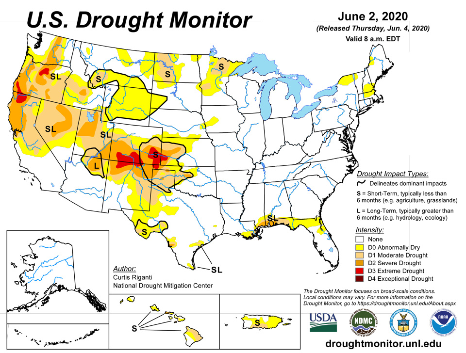
June 4, 2020 - This week, dry conditions were common across parts of the central and southern Great Plains, as well as parts of the northern Great Plains, particularly in North Dakota. Dry conditions were also common in much of the Intermountain West. However, above-normal rainfall occurred in eastern Washington, as part of an unusual severe thunderstorm event in Washington and Oregon on Saturday. Near or slightly below normal temperatures were found across much of the central and south-central continental United States, while warmer than normal temperatures (with some locations reaching between 5 and 15 degrees above normal) were common in the western High Plains and the West. Meanwhile, dry conditions also occurred along the northeastern Atlantic Coast. Above-normal rainfall fell in south Texas, central and south Florida, and parts of South Carolina and North Carolina. Moderate, severe, and extreme drought expanded in parts of the southern and central plains where high evaporative demand and paltry precipitation continued. Elsewhere, drought conditions also spread or lessened in parts of the West, where recent precipitation or lack thereof either improved conditions or caused conditions to dry out further. Minor changes in moderate drought were also made east of the Great Plains; for more details on these, please see the regional paragraphs.
Northeast
Warmer than normal temperatures occurred this week in the Northeast, particularly in New England. Temperatures from eastern Massachusetts to the Canadian border were mostly between 4 and 8 degrees warmer than normal. Well below normal precipitation occurred this week along the Atlantic Coast from Maryland north through Maine. Spotty areas of near- or above-normal precipitation occurred in parts of northern New York and New England. However, abnormal dryness increased in coverage in northern New York, southern Maine, southern New Hampshire and Vermont, and northeast Massachusetts, as short-term precipitation deficits, warm temperatures, and poor streamflow led to worsening conditions.
Southeast
Well above normal rainfall occurred this week in central and south Florida, which led to further improvements in drought and abnormal dryness in Florida and Alabama, including a complete removal of moderate drought and abnormal dryness from south Florida. Well above normal rain also fell in eastern South Carolina and much of central and southeast North Carolina. Elsewhere in the Southeast, above- and below-normal rainfall were somewhat spotty, likely due to the scattered nature of thunderstorms over the past week. Relatively moderate temperatures occurred this week in the Southeast, with most areas falling within 5 degrees of normal over the course of the week.
South
Conditions in the South this week varied widely from east to west, leading to primarily improving or unchanged conditions in the eastern part of the region, and degrading conditions in the west. Like the Southeast, most of the South had temperatures this week between 5 degrees above and below normal; however, notable exceptions on the warm end of this occurred in parts of the Texas and Oklahoma panhandles. Scattered areas of above- and below-normal rainfall dotted the region generally to the east of Interstate 35. Moderate drought slightly increased in coverage in a small area of southern Mississippi, where paltry rainfall occurred this week. Improvement in drought and abnormal dryness areas was common in south Texas and along the Texas Gulf Coast, where rainfall this week was mostly above normal. Areas of moderate and severe long-term drought slightly shifted along the Rio Grande, while otherwise degradation was quite common in West Texas and the Texas Panhandle. Extreme drought developed in the Oklahoma Panhandle, and adjacent areas of the southern and central high plains, where conditions had become extremely dry in the short-term as a result of low precipitation and high evaporative demand. Severe drought was also introduced in a small area northwest of Oklahoma City, where short-term precipitation deficits had worsened.
Midwest
Warmer than normal temperatures occurred in most of the Upper Midwest this week. In Wisconsin, Iowa, Minnesota, northern Illinois, and Michigan, temperatures between 4 and 10 degrees warmer than normal were common. The rest of the region saw variable, but generally closer-to-normal temperatures. A dichotomy developed this week between very dry short-term conditions in central and western Minnesota and wet conditions in southeast Minnesota, northeast Iowa, and Wisconsin. Abnormal dryness abated in northeast Iowa and adjacent parts of Wisconsin and Minnesota, where large rainfall amounts had lessened precipitation deficits. Meanwhile, moderate drought developed in north-central Minnesota and in west-central Minnesota. In both of these areas, short-term precipitation deficits have been building up over the past several weeks. Otherwise, some short-term dryness has started to appear in parts of southern Illinois and western Kentucky, but this has not yet developed into abnormal dryness.
High Plains
Warm and dry weather encapsulates the conditions across most of the High Plains this week, particularly in the western part of the region. Temperatures in the eastern part of the region were generally moderate, but temperatures from 3 to 12 degrees above normal were common in western Kansas, western Nebraska, and in eastern Colorado and Wyoming. Below-normal precipitation occurred in most of South Dakota and North Dakota, and primarily to the west of the U.S. 81 corridor in Kansas and Nebraska. Above-normal rainfall fell in parts of eastern Kansas, and a small area of above-normal rainfall also occurred west-northwest of Omaha, reducing the coverage of abnormal dryness in the Bohemian Alps and Platte River Valley areas of eastern Nebraska. Abnormal dryness expanded through much of central and eastern Wyoming to parts of northwest Nebraska and the Black Hills and Badlands in southwest South Dakota, due to increasing short-term precipitation deficits and, in Wyoming, high evaporative demand over the past month. Moderate drought increased in coverage along and north of the Missouri River in northwest North Dakota, where short-term precipitation deficits continued to build, and surface water shortages were indicated. In southeast Colorado and a small part of adjacent southwest Kansas, extreme drought expanded, as short-term precipitation deficits continued to worsen amid high evaporative demand.
West
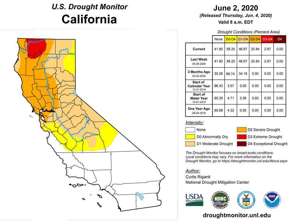
Warmer than normal temperatures were widespread in the West this week, particularly in the Intermountain West area, where temperatures 9 or more degrees above normal were commonplace. Below-normal precipitation in southwest Colorado and in parts of Utah, Wyoming, and Montana led to degradations in conditions. Severe drought increased in coverage in southeast Utah and southwest Colorado, where short- and long-term precipitation deficits continued to build amid high evaporative demand. Short-term precipitation deficits led to an increase in moderate drought coverage in southwest Montana. As mentioned in the High Plains paragraph, large evaporative demand and inadequate precipitation led to the development of widespread abnormal dryness across much of central and eastern Wyoming. Meanwhile, above-normal precipitation in eastern Washington and parts of north-central Oregon, where a localized severe weather event occurred on Saturday, led to improved conditions as precipitation deficits lessened. Also as a result of recent precipitation, extreme drought coverage lessened in southwest Oregon.
Alaska, Hawaii, and Puerto Rico
No changes were made to the U.S. Drought Monitor depiction in Alaska this week. In Puerto Rico, abnormal dryness expanded into the San Juan area, and moderate drought expanded across southern portions of the island, where short-term precipitation was low and soil moisture and streamflow had decreased. In Hawaii, abnormal dryness was reduced on Kauai, Lanai, Maui, and the Big Island. Moderate drought developed on the southern end of Oahu, and existing moderate and severe drought slightly expanded in coverage. Moderate drought was also introduced on Kahoolawe and in southern reaches of Lanai and Maui. Finally, moderate drought expanded in northeastern portions of the Big Island.
Pacific Islands
The weather conditions across the U.S.-Affiliated Pacific Islands (USAPI) during this USDM week (5/27/20-6/02/20) included surface and upper-level features. Faster-moving trade winds across northern Micronesia overtook slower-moving winds to the south, creating trade-wind convergence which generated showers across parts of the Marshall Islands (RMI) and Federated States of Micronesia (FSM). Surface troughs were embedded within the trade-wind flow, enhancing showers. A weak circulation briefly manifested in RMI waters. A couple of upper-level lows/troughs slowly migrated westward along the northern fringe of Micronesia, with their upper-level divergence enhancing showers over parts of the FSM and RMI. Dry trade winds dominated the Marianas until an embedded trade-wind trough brought beneficial rains to southern portions of the Marianas. South of the equator, an unstable air mass and surface trough brought rain to the Samoan Islands.
Satellite-based estimates of 7-day precipitation (QPE) showed two bands of precipitation, one stretching eastward from Micronesia across the Pacific between the equator and 10 degrees North latitude, the other extending southeastward from Indonesia past the Samoan Islands. A few areas of 1+ inches of rainfall were indicated across Palau and Yap State, with areas of 2+ inches evident across eastern FSM and RMI. The satellite QPE indicated rainfall over Guam, but at levels less than rain gauge measurements. Areas of 2+ inches were widespread across, west, and south of the Samoan Islands.
In Palau, several tropical systems (one of which became Typhoon Vongfong, the first Tropical Cyclone of the 2020 season) brought enough rainfall within the first eleven days of May for a majority of stations across Palau to meet most water needs for the month (at least 8 inches). During the second half of May, rainfall was mainly generated by the convergence of moderate-to-strong trade winds north of troughs found mainly south of Angaur. On May 22nd, the Palau Public Utilities Corporation lifted the nationwide mandatory water rationing. By the end of the month, WSO Palau's (Airai's) rainfall total set a new May record at 24.24 inches (154% of median). The previous record (2004-2017) was 20.41 inches, set back in 2005. Rainfall at the Koror COOP fell just short of setting the record for May, with 23.12 inches measured (195% of median). Aimeliik and Melekeok received 19.65 inches and 18.86 inches of rain, respectively, for the month of May. Some impacts of the excessively heavy rainfall included road damage (especially potholes and cracks) and flooding. In stark contrast to the excessively heavy rains that fell upon a majority of the stations in Palau, the region of Peleliu received very little in comparison (3.99 inches; about half of the monthly minimum requirement to meet most water needs). For the current drought week, the Palau International Airport observed 0.53-inch of rain, and the Koror COOP measured 1.16 inches, with both stations falling well short of the 2-inch minimum weekly rainfall requirement. Palau continues to have drought-free conditions.
Guam reported 3.06 inches of rain this week, which is over three times the weekly minimum needed to meet most water needs, thanks to yet another trade wind disturbance. This rainfall helped replenish central Guam's Lake of Nimitz (Lago de Nimitz) Hill, and invigorated a significant invasive toad population. In the north, Dededo reported 5.34 inches of rain. For May 2020, the monthly rainfall totals for both Guam and Dededo, respectively, are 8.17 inches (more than double the monthly minimum) and 8.46 inches. In fact, for Guam, May 2020 ranked 55th out of 64 "May's" on record, which translates to nearly the 86th percentile. Guam's drought classification remains at moderate drought (D1-S) this week, with short-term impacts. Rota picked up 1.97 inches of rain this week. This is the only "wet" week in the past 12 weeks. May 2020 was relatively dry with 2.63 inches of rain reported, well shy of the 4-inch monthly minimum. In the past 6 months, Rota has experienced only one wet month, which was February 2020 when 5.58 inches of rain fell. Tinian reported 0.87-inch of rain this week. Rainfall amounts varied widely across Saipan this week. A manual gauge recorded 1.16 inches of rain, an automated ASOS station measured 0.88-inch, and an automated NPS station measured a scant 0.07-inch (2 days missing). Degradation from extreme drought (D3 SL) to exceptional drought (D4 SL) was considered last week; given substantial precipitation fell this week across parts of Saipan, it was decided to hold off (at least for now) on additional deterioration.
In the western Federated States of Micronesia (FSM), Yap received 1.32 inches of rain this week. This is two-thirds of the rainfall needed to meet most water needs for the week. For the month of May, 8.22 inches of rain was measured which is 97% of normal. The water reservoir near the main town continues to remain low. Yap's drought category remains at D2(S) this week. Within the state of Yap, the village/municipality of Rumung reported 0.75-inch of rain this week, and 9.29 inches for the month of May. Ulithi had no rain this week (1 day missing), and 9.90 inches during May. D1(S) conditions continue at Ulithi. Woleai experienced a relatively dry week with 0.60-inch of rain reported. For May, the rainfall total was 10.54 inches. Woleai reported water catchment tanks are more than half full, but the water quality in these tanks is low. D1(S) conditions continue at Woleai. In central sections of Micronesia, North Fanif reported 1.13 inches of precipitation this week, and measured 11.59 inches for the month of May. Chuuk Lagoon recorded 1.91 inches of rain this week. The accumulation for the month of May 2020 is 13.09 inches of rain, which is well above the 8-inch monthly minimum required to meet most water needs. Chuuk Lagoon's drought designation remains at D0(S). Lukunor picked up 3.97 inches of rain this week, which is nearly double the minimum rainfall requirement for the week. The total rainfall for May 2020 was 10.70 inches (1 day missing), which is more than adequate to meet most water needs for the month. Lukunor remains drought-free. Nukuoro measured 2.66 inches of rain this week, which is more than adequate. The May 2020 rainfall total of 11.82 inches was more than sufficient to meet most water needs for the month. Like Lukunor, Nukuoro continues to be drought-free. Relatively dry conditions continue at Kapingamarangi. By the end of this drought week, 1.49 inches of rain had fallen in the rain gauge. For the month of May only 3.93 inches of rain was noted, not quite half of the 8-inch minimum requirement. This month ranks as the third driest May in the 26-year record (11.5th percentile). In the eastern portion of the FSM, Pohnpei measured 1.60 inches of rain this week. For the month of May 2020, excessive rainfall amounts were noted (24.91 inches), which is over three times the monthly minimum of 8 inches. Accordingly, Pohnpei retains its drought-free status. Pingelap and nearby Mwoakilloa were both wet this week, with 4.60 inches and 3.67 inches, respectively. Kosrae experienced a very wet drought week, with a total of 6.98 inches of rain reported. Kosrae also had an excessively wet May, with 29.05 inches of rain accumulating over the 31-day period. The rainfall total in May ranks 48th out of 52 years on record (percentile of 92.3). Kosrae obviously retains its drought-free status this week.
The atoll of Kwajalein in the Republic of the Marshall Islands (RMI) had 1.77 inches of rain this week, which falls a bit short of the weekly minimum precipitation requirement of 2 inches to meet most water needs. Kwajalein's drought category remains at D1(SL). Nearby Ailinglapalap received 5.15 inches of rain this week (2 days missing). In May, Ailinglapalap measured 8.50 inches of rain, with 2 days of data missing. Its drought designation remains at D1(SL) this week. Despite earlier problems with rainfall data, Jaluit reported 1.07 inches of rain for the week, and maintains its drought-free designation. Unfortunately, data problems persist at Utirik, precluding any analysis for this location this week. Wotje reported 2.99 inches of rain this week. For the month of May, 5.50 inches of rain fell (3 days missing), which falls well short of the 8-inch minimum. Wotje retains its D3(SL) depiction this week. In Mili 3.7 inches of rain was measured. For May, Mili's accumulation was 11.04 inches (4 days missing). Considering these weekly and monthly precipitation totals, it is clear that Mili remains drought-free, as does its neighbor, Majuro, which received an even greater weekly total of 6.58 inches. The observed precipitation in May (13.67 inches) comfortably surpassed the 8-inch minimum requirement. As of June 3rd, the Majuro reservoir storage stood at 34.1 million gallons, which is 94.7 percent of its full capacity.
This was a wet week for American Samoa, with three key sites receiving well over the 1-inch weekly minimum rainfall to meet most water needs. Pago Pago reported 1.45 inches this week. Two NPS automated sites on Siufaga Ridge and Toa Ridge, measured 2.20 inches and 1.75 inches, respectively for the week (each missing one day of data). Drought-free conditions persist at Tutuila this week.
Virgin Islands
Parts of St. Thomas received significant rainfall during this drought week, May 27-June 2, 2020. Rainfall at Anna's Retreat (CoCoRaHS VI-ST-1) during this week measured 0.65-inch, with nearly all of it falling on May 28-29. A new observer at Magens Bay reported a heavy rain event occurred on May 28-29, when 1.28 inches fell during the 24-hour observation period. In the near future, rainfall measurements should be available via the CoCoRaHS system. Though rainfall data was unavailable this week from the Cyril E. King Airport, nearby private stations and radar estimates provide an approximate rainfall amount of 1.55 inches on May 28th. The USGS Grade School 3 well in Charlotte Amalie currently has a water level about 12.5 feet below the land surface. This is the lowest level that has been observed since July 2019, when the water level was almost exactly at the same depth below the land surface. SPI values at 1,3,6, 9, and 12 months for Charlotte Amalie are: -1.83, -1.27, -0.13, -1.16, and -0.30, respectively. The drought category at St. Thomas remains unchanged this week at D2(S).
Farther east, an observer on Windswept Beach, St. John, measured just over 2 inches of rain for the month of May, as the dry spell continues. Windswept Beach apparently missed out on the heavier rainfall amounts observed on other parts of the island on May 28-29. Provisional well data provided by the USGS for the Susannaberg DPW 3 well on St. John's shows the continuation of a steep decline in water level since very late January/very early February of 2020. At that time, the water level was just over 8 feet below the land surface, the highest it's been during at least the past 12 months. Since then, the water level has rapidly dropped to its current value of nearly 16 feet below the land surface. SPI values at 1,3,6, 9, and 12 months for Windswept Beach are: -0.95, -1.14, +0.07, -0.60, and -0.34, respectively. The drought classification for St. John remains unchanged this week at D2(S).
At St. Croix this week, the Henry E. Rohlsen Airport reported only a trace of rain since the start of June. Only 0.56-inch of rain was reported at the airport in May, which is 3.59 inches below normal for the period. The Year-To-Date (YTD) rainfall total is 8.68 inches, which is 3.15 inches below normal for the same period. CoCoRaHS data for stations VI-SC-8 (Christiansted 1.8 ESE) and VI-SC-9 (Christiansted 4.1 ESE) shows paltry weekly rainfall accumulations of 0.05-inch and 0.15-inch, respectively. Mostly dry weather prevailed at the UVI sheep research facility this week, but the actual rainfall total was unavailable. Provisional USGS well data from the Adventure 28 well in St. Croix indicates a current water depth that is about 20 feet below the land surface. For the past three months, the water depth has varied between about 19.5-20.2 feet. SPI values at 1,3,6, 9, and 12 months for Christiansted are: -1.40, -0.40, -0.66, -2.02, and -1.42, respectively. The drought category at St. Croix remains unchanged this week at D2(SL).
Looking Ahead
As of the afternoon of Wednesday, June 3, the National Weather Service Weather Prediction Center is forecasting dry weather to continue over the southern Great Plains and the central and southern high plains from June 4 to the evening of June 8. Heavy precipitation is possible from the central Gulf Coast eastward into the Florida Peninsula. Through the evening of June 10, heavy precipitation is also possible in the Mississippi River Valley, as well as eastern portions of Nebraska, North Dakota, and South Dakota. Some of the forecast rainfall will likely be dependent on the evolution of Atlantic tropical cyclone Cristobal. Please monitor forecasts from your local National Weather Service office and the NWS Weather Prediction Center for rainfall forecasts and for information on possible hydrological impacts from Cristobal. For the latest information on Cristobal, please refer to information and forecasts from the National Hurricane Center. The Climate Prediction Center is forecasting increased chances for warmer than normal temperatures in California and across southern New Mexico, Texas, Louisiana, and the southeast Atlantic and Gulf Coasts for June 9-13. Meanwhile, near-normal or below-normal temperatures are forecast over much of the rest of the continental U.S. during this period. Increased chances for above-normal precipitation are forecast in the eastern and central United States as well as in the Pacific Northwest, while increased chances for below-normal precipitation are forecast in the High Plains, Texas, Oklahoma, and the Rocky Mountains.
Author(s):
Curtis Riganti, National Drought Mitigation Center
Anthony Artusa, NOAA/NWS/NCEP/CPC
Dryness Categories
D0 Abnormally Dry—used for areas showing dryness but not yet in drought, or for areas recovering from drought.
Drought Intensity Categories
D1 Moderate Drought
D2 Severe Drought
D3 Extreme Drought
D4 Exceptional Drought
Drought or Dryness Types
S Short-Term, typically less than 6 months (e.g. agricultural, grasslands)
L Long-Term, typically greater than 6 months (e.g. hydrologic, ecologic)
Source: National Drought Mitigation Center

