


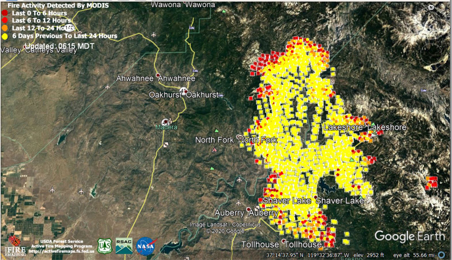
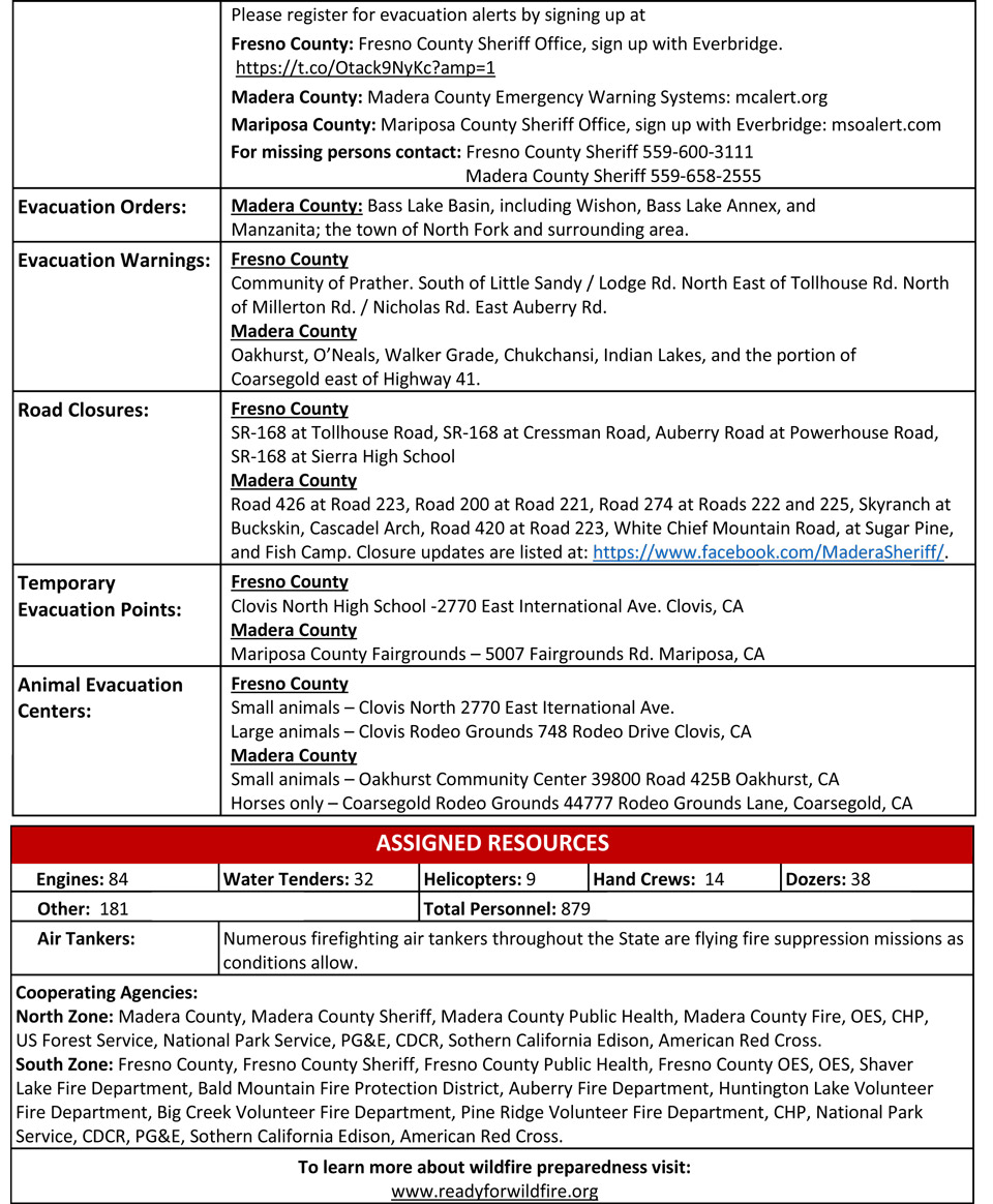
 MODIS map of the Creek Fire on Wednesday at 5:15 A.M. PST
Note: 1,500 Wide
MODIS Active Fire Mapping Program Frequently Asked Questions
Update Per Madera County Sheriff's Office: Creek Fire Information Update
*Evacuation update as of 8:00 p.m. on 9/9*
All mandatory evacuation orders and evacuation warnings remain the same. Please call 311 to Duran with a live person to receive answers to question, sign up for our alerts, and continue to followers here. Stay safe, Madera County.
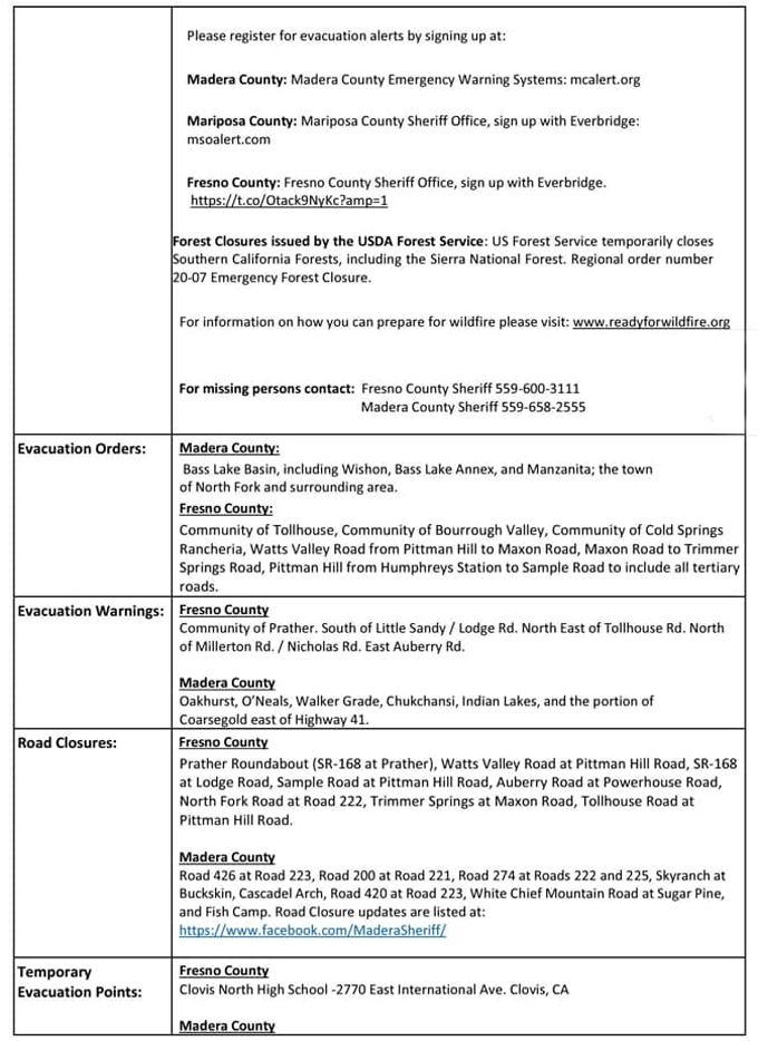
BASS LAKE Basin is under mandatory evacuation. This includes Everything south and east along Road 222 and Road 274 into North Fork. Everything south and east of Road 223 and Road 426 is also under mandatory evacuation. This includes WISHON, BASS LAKE ANNEX, AND MANZANITA under mandatory evacuation. These roads are open to evacuating traffic only. No through traffic.
The town of NORTH FORK and surrounding area is under mandatory evacuation order. Road 221, Road 222, Road 226, and Road 200 and all tributary roads are included.
An Evacuation Order means there is an immediate threat to life, and is an order to leave now. The area is being closed to public access. Take action immediately.
The Northwest portion of OAKHURST is under Evacuation Warning. This includes Road 223 and Road 426 west to Highway 41, between Road 200 and Road 222.
The area east of Highway 41 and Road 200 to Road 223 (to include O’Neal’s, Walker Grade, Chukchansi, Indian Lakes, and the portion of Coarsegold east of Highway 41) are under Evacuation Warning.
The area of Road 222 to Highway 41 is under Evacuation Warning. This includes Petit Road, Crass Drive, Old Corral Ranch Road, Dorstan Drive, Road 220, and Hidden Falls Road.
An Evacuation Warning means there is a potential threat to life and property. Please monitor the situation and be prepared to take action immediately. Don’t wait for an order to leave if you feel threatened.
The Red Cross has set up a hotline for evacuee shelter information at 571-595-7401.
Those who need evacuation assistance should call 559-675-7770 or 911.
Update 10:00 P.M. CAL FIRE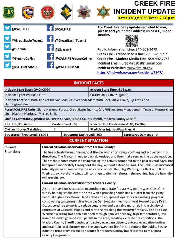
Update 9:30 P.M. Per InciWeb: Creek Fire Basic Information Update
Current as of 9/9/2020, 9:28:27 P.M.
Incident Type: Wildfire
Cause: Under Investigation
Date of Origin: Friday September 04th, 2020 approx. 06:00 P.M.
Location: Both sides of San Joaquin River near Mammoth Pool and the communities of Shaver Lake, Big Creek and Huntington Lake.
Incident Commander: Unified Command, IC N. Truax CAL FIRE Team 1,M. Adell Great Basin Team 1, and the USFS
Coordinates: 37.333 latitude, -119.444 longitude
Current Situation
Total Personnel: 879
Size: 166,965 Acres
Fuels Involved: Large expanses of beetle kill, 80-90 percent of stand. Timber, Brush, Understory Litter
Significant Events: North Zone - Fire activity remains active about the inversion layer. Under the inversion, fire activity was low to moderate.
South Zone - The fire activity burned throughout the night with short range spotting and active runs. The critical fuels were completely consumed in portions of the fire. Active crown runs were observed in timber stands in the higher elevations.
Current Weather: Weather Concerns: Red Flag warnings are in effect until Wednesday at 8:00 P.M. for gusty winds and low relative humidity.
Update 9:27 P.M. Two North Fork Residents Arrested in the Creek Fire Mandatory Evacuation Zone on Multiple Charges
Update 8:00 P.M. Per CAL FIRE: The Creek Fire is now at 166,965 acres, with 0% containment. There are 1,336 personnel working the fire at this time.
Update 6:20 P.M. Per Mariposa County Sheriff's Office: The Fire Advisement (this is the same thing as an Evacuation Warning) for the following remains in effect: Fish Camp - This includes all areas of Fish Camp from the Mariposa County Line to the Yosemite National Park Boundaries. For areas of Fish Camp in Madera County please refer to Madera County Sheriff's Office.
This is NOT a Mandatory Evacuation, this is an advisement only of fire in the area, allowing you to prepare for a potential Evacuation Order should conditions change. Fire conditions can change at any moment so please start to prepare.
Don’t wait for an evacuation order to leave if you feel threatened. If you feel unsafe, please leave the area.
ROAD CONDITIONS As of right now Highway 41 thought Oakhurst and Wawona are open with no restrictions. Highway 140 through Yosemite and El Portal are open with no restrictions. Hwy 49 is open with no restrictions.
As a reminder- road conditions can change at any moment so please plan multiple exit routs.
Update 6:20 P.M. Per SNFS: Sierra National Forest to Hold a Livestream Incident Briefing with CAL FIRE for the Creek Fire Tonight (Wednesday) at 7:00 P.M.
Update 10:40 A.M. Forest Service Wildland Fire Smoke/Air Quality Outlook Due to the Creek Fire in the Yosemite Area for September 9 & 10, 2020
Update 10:20 A.M. CAL FIRE: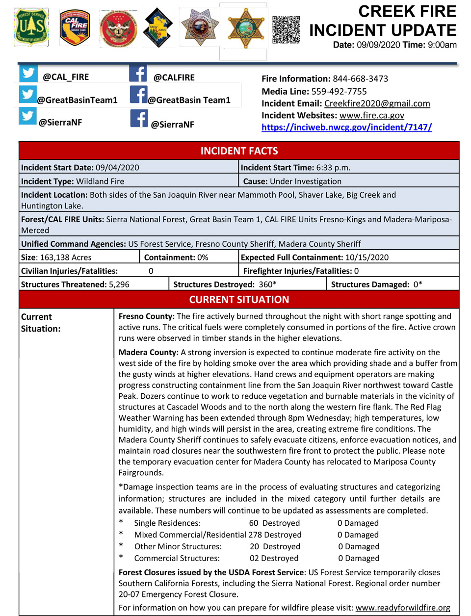
Update 9:14 A.M.: YARTS reservations on the Hwy 41 corridor have been canceled: Wednesday, September 9th – Friday, September 11th due to a wildfire. Contact: tickets@yarts.com to request a refund. Due to an increase in demand, refunds may take longer to process. Thank you for your understanding.
Update 8:40 A.M. NWS Bay Area: Reminder: AQI sensors focus on smaller particulates such as PM10/PM2.5. Some ash falling is larger than PM10 (width of human hair) & may not be reflected in AQI. Finer particulates remain suspended while larger fall. Take precautions to protect your lungs such as wearing a mask.
Update: 7:50 A.M. CAL FIRE: 163,138 Acres with 0% Containment and 365 Structures Destroyed
NOTE: Updated above at 10:20 A.M.
Update: 5:55 A.M. Sierra National Forest Creek Fire Operations Briefing Map for Wednesday, September 9, 2020
Comments and notes on flight:
The fire progression has slowed but it still has grown considerably to the south and east as the interior is beginning to cool. Intense heat is still present around most of the perimeter, however the main areas of activity are in the southern tip (Divisions W and V) and the northern portion (Divisions F, G, and I), as well as some to the east as well (Division R).
Tuesday Information: As of Tuesday evening: 152,833 Acres Acres with 0% Containment
Sierra National Forest Creek Fire Updates for Tuesday, September 8, 2020
