


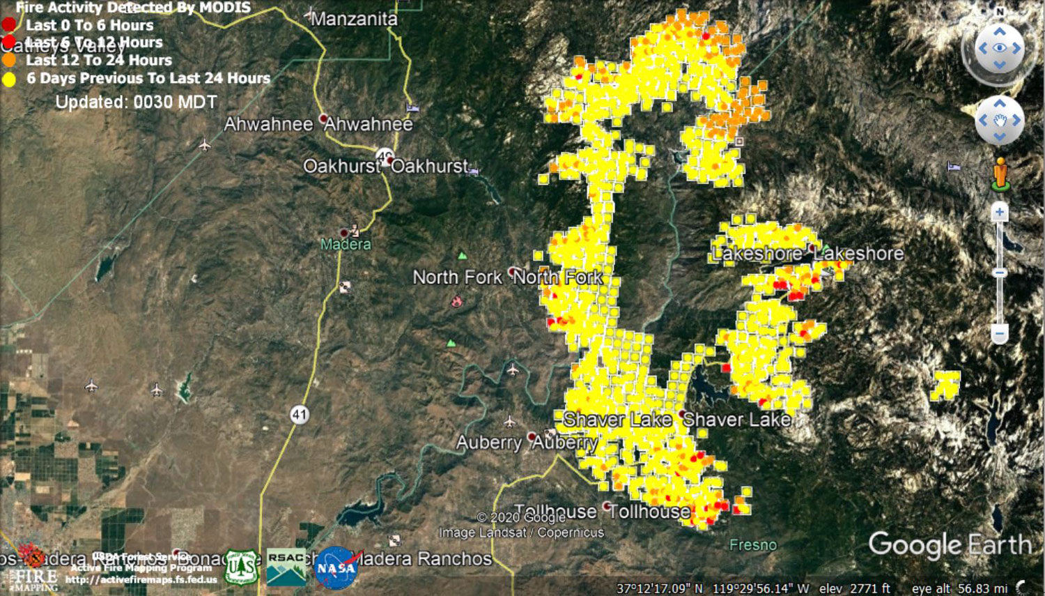
 MODIS map of the Creek Fire on Friday at 0:30 A.M. MDT (Older Map)
Note: 1,500 Wide
MODIS Active Fire Mapping Program Frequently Asked Questions
Update 9:00 P.M. Creek Fire Basic Information Update
Current as of: 9/11/2020, 8:46:25 PM
Incident Type: Wildfire
Cause: Under Investigation
Date of Origin: Friday September 04th, 2020 approx. 06:00 PM
Location: Big Creek, Huntington Lake, Shaver Lake, Mammoth Pool, San Joaquin River Canyon
Incident Commander: Nick Truax CAL FIRE IMT1, Martin Adell Great Basin IMT1, Madera County SO, Fresno County SO
Coordinates: 37.201 latitude, -119.272 longitude
Current Situation
Total Personnel: 1,811
Size: 182,225 Acres
Percent of Perimeter Contained 6%
Estimated Containment Date: Thursday October 15th, 2020 approx. 12:00 A.M.
Fuels Involved: The fuels in the area consist of large expanses of beetle kill timber, 80-90 percent of the stand. The fuel loading in the timber is estimated at 2,000 tons an acre. The brush in the area is at critical levels, 60 percent in the ceanothus and manzanita. Thousand hour fuels are at 6 percent moisture level.
Significant Events
North Zone - Fire activity remains active and intense in heavy fuels above the smoke layer. Under the inversion, fire activity was low to moderate in all fuel types.
South Zone - The fire progressed with backing and flanking runs throughout the night. An occasional slope run with torching was observed when the fire reached the base of the slopes. The main fire spread was in the southeast and northeast portion of the fire. The higher elevations with the high-density tree mortality continue to actively burn through the night even with the slight humidity recovery.
Outlook
Planned Actions: Structure defense and perimeter control.
Clear roads as needed to ensure egress.
Construct, strengthen and improve control lines.
Primary, Alternative, Contingency, and Emergency (PACE) planning - Identify and construct primary, alternate, and contingency lines.
Projected Incident Activity
North Zone: Fire edge should remain in place from the San Joaquin River to Shuteye Lookout. Fire activity overnight in the Central Camp, Wet Fork Chiquito Creek, Johnson Meadows, and Graveyard Meadows.
South Zone: The winds will mainly be terrain driven, continuing to move the fire into the deep canyons. Communities affected will be Auberry, Shaver Lake, and Prather. Short range spotting will continue to be an issue throughout the fire. The fire will transition from the timber in the lower elevations to brush and grass. Fire will continue to spread to the north and east due to the heavy fuels. A new spot well outside of the current perimeter on the northeast portion of the fire will continue to grow with the wind and fuels.
Remarks: The reason the estimate fire acreage did not increased is because we have not been able to obtain good infrared data. We know that the fire is still growing and will update when reliable data become available.
Current Weather
Weather Concerns: North Zone: Continued heavy smoke overnight kept the weather calm with a strong inversion in place along with light down canyon winds. Moderate humidity recovery but poor in some thermal belts around 3000-4000 feet along the San Joaquin River drainage.
South Zone: Heavy smoke blanketed the Creek Fire with relatively light winds overnight. Temperatures will be on the cool side as smoke will filter sunshine. The relative humidity will remain on the lower side despite the lack of sunshine.
Update 8:50 P.M. Fresno County Sheriff's Office Requests Help Reducing Call Volume During Creek Fire
Update 7:00 P.M. The Creek Fire is now at 182,225 acres, with 6% containment. There are 1,811 fire personnel working the fire.
Sierra National Forest to Hold a Livestream Incident Briefing with CAL FIRE for the Creek Fire Tonight (Friday) at 7:00 P.M.
Update 4:45: Per Madera County Sheriff's Office: 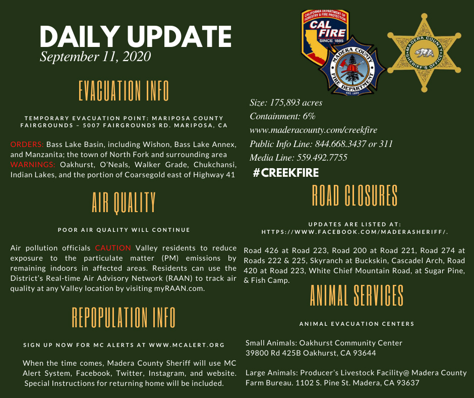
Update 3:44 P.M. Forest Service Wildland Fire Smoke/Air Quality Outlook Due to the Creek Fire in the Yosemite Area for September 11 & 12, 2020
Update 2:11 P.M. CAL FIRE Statewide Fire Update Video for Friday, September 11, 2020
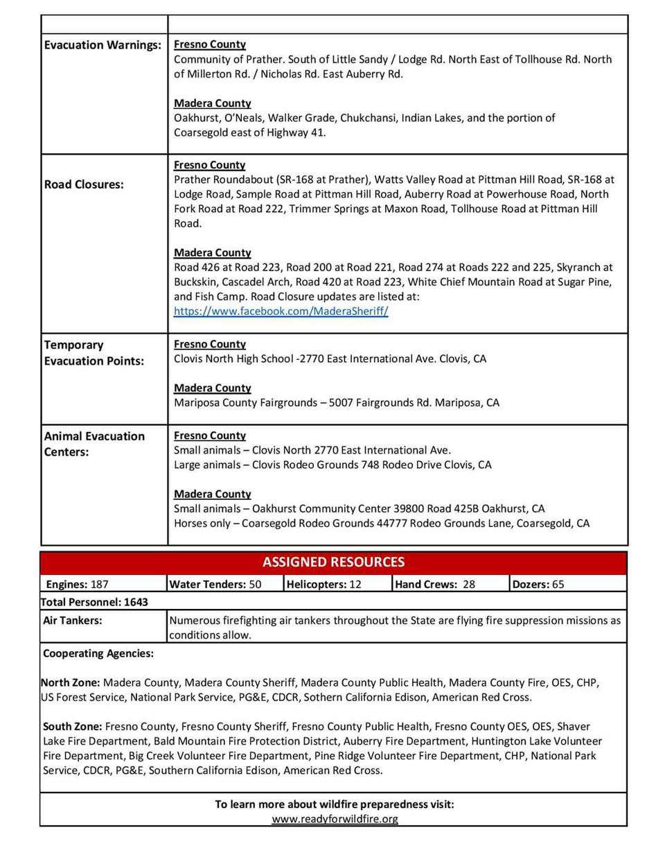
Update: 9:30 A.M.: 175,893 acres, 6% containment and 365 structures destroyed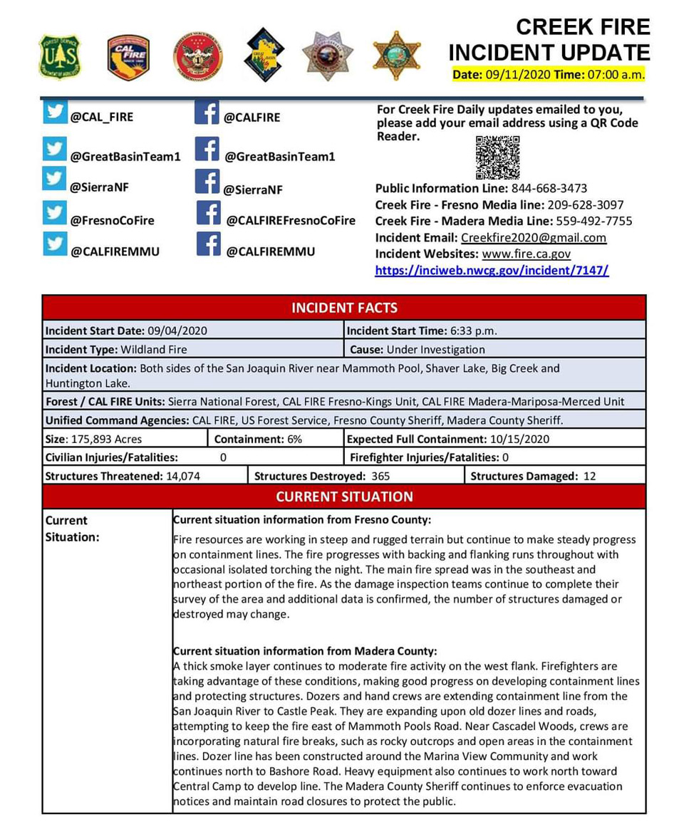

Update 5:50 A.M.: Sierra National Forest Creek Fire Operations Briefing Map for Friday, September 11, 2020
September 11, 2020 - Overnight infrared mapping has the Creek Fire at 175,893 Interpreted Acres.
Comments and notes on flight:
UTF – Weather. Thick smoke and fog reduced airfield visibility <1 statute mile.
Thursday Evening Update: 175,893 acres and 6% containment, with 1,336 total fire personnel.
Sierra National Forest Creek Fire Updates for Thursday, September 10, 2020
