


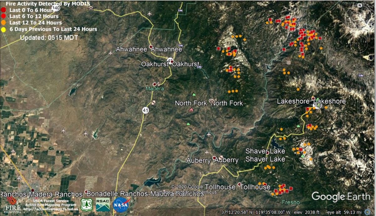
 MODIS map of the Creek Fire on Sunday at 4:15 A.M. PST
Note: 1,200 Wide and older yellow detections removed
MODIS Active Fire Mapping Program Frequently Asked Questions
Update 7:24 P.M. Per CAL FIRE: Creek Fire is now at 201,908 Acres, with 10% Containment.
Basic Information
Current as of 9/13/2020, 7:24:00 PM
Incident Type: Wildfire
Cause Under: Investigation
Date of Origin: Friday September 04th, 2020 approx. 06:00 PM
Location: Big Creek, Huntington Lake, Shaver Lake, Mammoth Pool, San Joaquin River Canyon
Incident Commander: Nick Truax CAL FIRE IMT1, Martin Adell Great Basin IMT1, Madera County SO, Fresno County SO
Coordinates: 37.201 latitude, -119.272 longitude
Current Situation
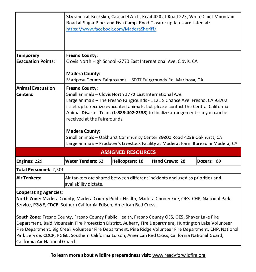
Total Personnel: 2,503
Size: 201,908 Acres
Percent of Perimeter Contained:10%
Estimated Containment Date: Thursday October 15th, 2020 approx. 12:00 AM
Fuels Involved: The fuels in the area consist of large expanses of beetle kill timber, 80-90 percent of the stand. The fuel loading in the timber is estimated at 2,000 tons an acre. The brush in the area is at critical levels, 60 percent in the ceanothus and manzanita. Thousand hour fuels are at 6 percent moisture level.
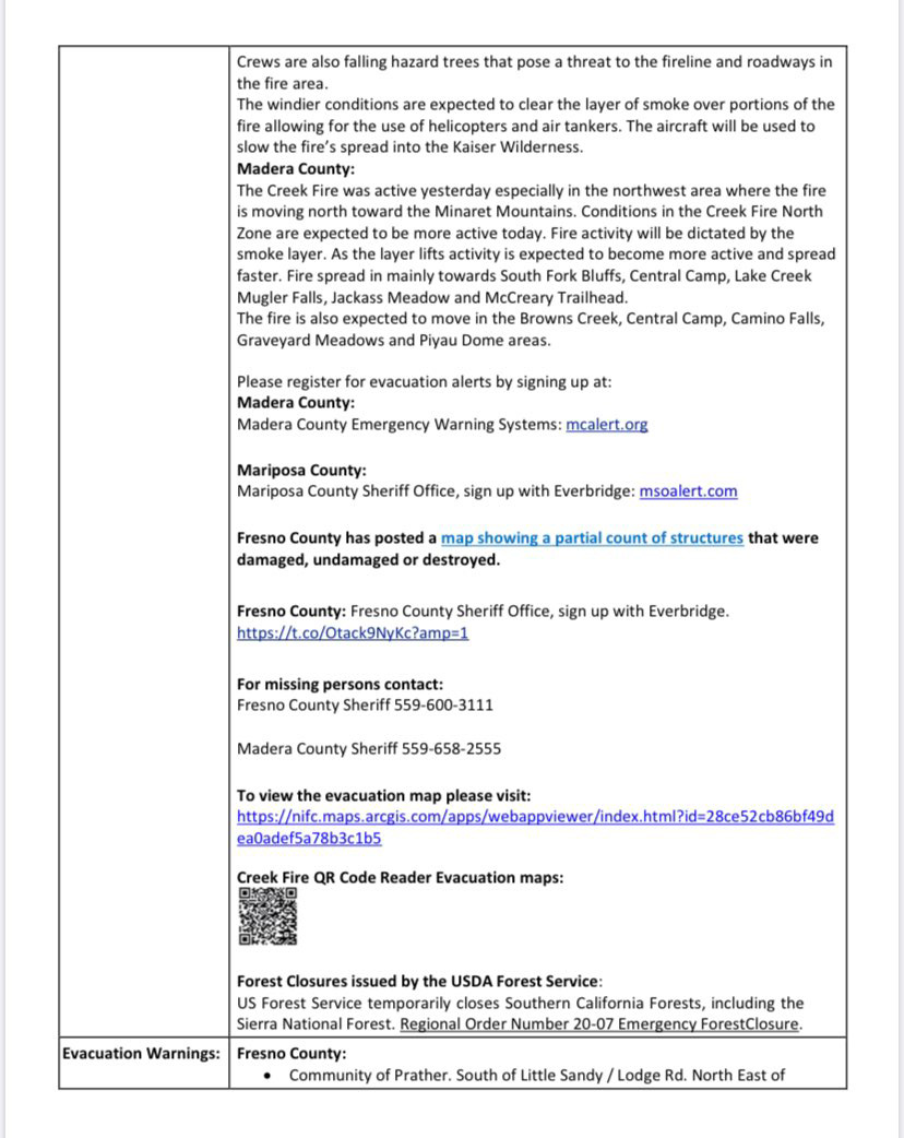
Significant Events
North Zone - Extreme fire behavior, with short crown runs and sustained torching. Spotting up to 1 mile towards the north and northeast.
South Zone - The eastern portion of the fire also became active in the afternoon. The southern portion of the fire became shaded from smoke from the Castle Fire, however rolling material and short range spotting continued to be an issue.
Outlook
Planned Actions
Structure defense and perimeter control.
Tactical patrol around structures in the burn.
Construct, strengthen and improve control lines.
Fall hazard trees and trees that threaten control lines.
Primary, Alternative, Contingency, and Emergency (PACE) planning - Identify and construct primary, alternate, and contingency lines.
Projected Incident Activity
North Zone: Fire activity will be high throughout the evening with crowning torching and spotting. Fire will progress primarily to the north and northeast towards McCurry Trailhead, Jackass Meadow, Portuguese View Point, Globe Rock, and Little Shuteye Peak. Fire will also continue moving towards Central Camp, South Fork Bluffs, and Whiskey Falls.
South Zone: The winds will mainly be terrain driven, continuing to move the fire into the deep canyons. Communities affected will be Auberry, Shaver Lake, and Old Bretz Mill. Short range spotting will continue to be an issue throughout the fire. The fire will transition from the timber in the lower elevations to brush and grass. Fire will continue to spread to the north and east due to the heavy fuels, towards the Minaret Mountains.
Current Weather
Weather Concerns
North Zone: Smoke was less over the mid slopes to ridges today and that trend will continue for the next 48 hours, but smoke will continue to hang in the drainages and lower elevations. Winds will continue to be upslope, but moderated due to smoke with ridge winds more from the southwest. Peak gusts on the ridges will continue to be 25 to 30 mph, mainly toward the Sierra Crest on the northeast side. Temperatures will remain warm, but moderated due to smoke with relative humidity in the teens every day, with poor recovery for thermal belts to 25%. A stronger wind event is possible beyond 72 hours with gusty southwest winds for Thursday into Friday.
South Zone: Heavy smoke from the SQF Complex to the south drifted north over the Creek Fire today moderating weather conditions. Despite the smoke and ashfall, the airmass over the region remained really dry with low relative humidity. Winds were southwest over higher elevations, but terrain driven over lower elevations. Smoke will settle into lower elevations tonight with little to no recovery.
Update 4:30 P.M. REMINDER - Per Fresno County Sheriff's Office: The following message is directed to folks who were forced to leave their vehicles behind once they had to escape the Creek Fire. Primarily, these are people who were in the high country in Fresno County; specifically in places such as China Peak, Mono Hot Springs, Edison Lake and Florence Lake.
The Fresno County Sheriff’s Office is in the process of making arrangements, once conditions become safe, to provide transportation for the vehicle owners to retrieve their vehicles. The majority of these folks were air evacuated by the Army National Guard and their vehicles were left behind.
We are asking you to provide us the following information:
- First and last name
- Phone number
- License plate number
- Vehicle description
- Name on vehicle registration
- Location of vehicle
Please email the information to tony.botti@fresnosheriff.org
At this time, we are prioritizing for those visitors parked at various campsites. We are not making arrangements to retrieve vehicles parked at homes.
Members of the public who have already contacted our office and given us the above information do not need to contact us again.
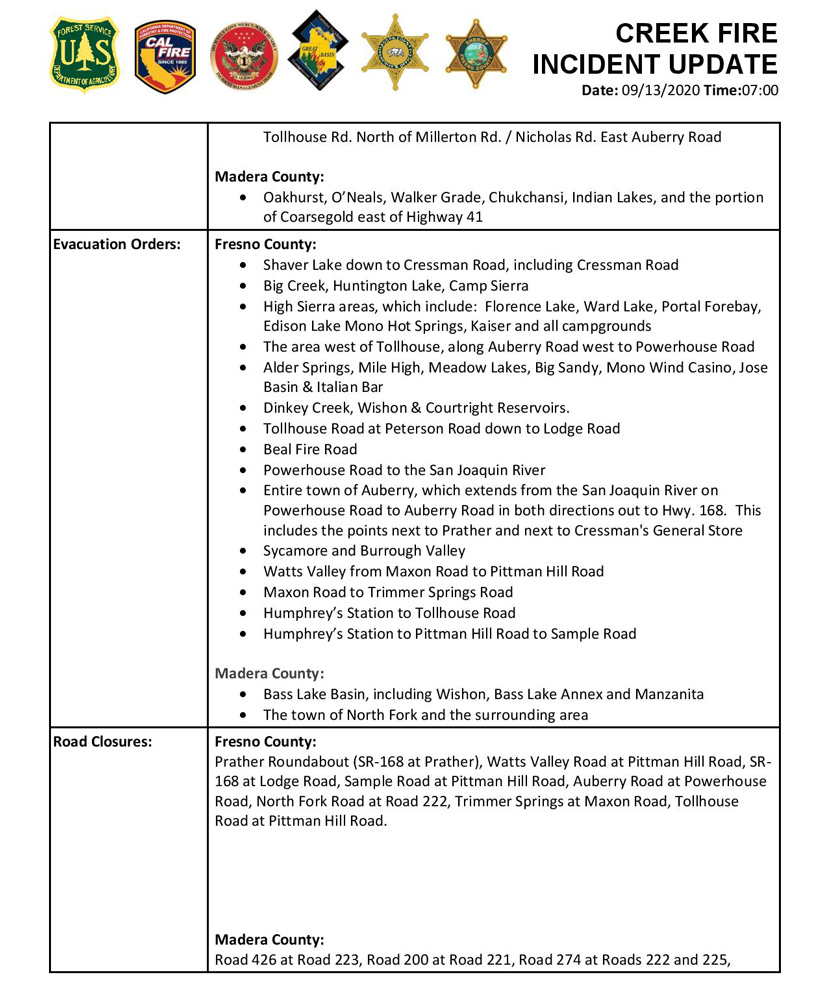
Update 4:15 P.M. Per Madera County Sheriff's Office: Evacuation Orders for the following areas have been reduced to Evacuation Warnings. Residents in the area need to be aware that there is still a potential for evacuations and need to be prepared to evacuate at a moments notice. Citizens need to monitor the situation and be prepared to take action immediately. These areas are being opened to residents only.
-Road 222 between Road 274 and Bass Lake Dam including all spur roads such as Saddleback Road and Emory Lane (Evacuation Zone M25).
-Road 222 between Road 226 and Road 225 including all spur roads such as Way Up Way (Evacuation Zones M32 and M31).
-Road 223 between Road 426 and Road 221 and all spur roads such as Woodland Pond Trail, Smiley Meadows Court, Pinchot Drive, Pine Oak, Smiley Mountain Road, Northridge Road, Church Ranch Road, Taylor Ridge Road, Timberview Road, Finegold Creek Drive, Teaford Poyah, Woaka Poyah, and Hidden Meadows Road (Evacuation Zones M38, M47, M37, M46).
-Road 221 from Road 222 to Road 200 and all spur roads such as Oak Leaf Way, Munson Lane, and Shady Oaks Drive, Kowana Lane, Pahuma Way, Nielsen Road, Quail Flats Drive, Sunridge Drive, and Klette's Pride Way (Evacuation Zones M26, M35).
-Road 226 between Road 221 and Road 222 and all spur roads such as Bishop Park Place, Deer Springs Lane, Walker Ranch Road, and Keller Road (Evacuation Zones M26, M23, M32).
-Road 224 between Road 226 and Road 200 and all spur roads such as Horn Road, Mountain Springs Road, Priest Road, Wilcox Drive, Wild Plum Lane, and Quail Hollow Court (Evacuation Zones M28 and M29).
-Road 200 between Road 221 and Road 222 and all spur roads such as Wild Plum Lane, Tahoot Drive, Maranatha Drive, Golden Acorn Court, Ellis Way, Rocky Road, and Cougar Springs Trail (Evacuation Zones M27, M28, M29, and M35).
-Road 225 between Road 222 and Road 274 including all spur roads such as Amber Lane, Willow Creek Drive, Weatherly Lane, and Buckhorn Court (Evacuation Zone M30).
Update 2:26 P.M. Sierra National Forest Incident Weather Video Update from Jim Wallmann, Incident Meteorologist on Creek Fire for Sunday, September 13, 2020
Update 2:05 P.M. Forest Service Wildland Fire Smoke/Air Quality Outlook Due to the Creek Fire in the Yosemite Area for September 13 & 14, 2020
Update 11:15 A.M. Madera County Sheriff's Office: Highway 41 Area, Evacuation Warning Areas Lifted in Zones M 58 to M 87. These zones include the general Highway 41 corridor between road 200 and Bass Lake Road, also known as Road 222. Please see the Evacuation Map for specific details, you will see those zones now in Green. All other Madera County Mandatory Evacuation Orders and Evacuation Warnings remain in effect. To view a map of the affected areas, please visit Sheriff’s Office Facebook Page for a link. Please remember that there will remain a large amount of traffic related to the fire in the area. Please drive carefully and watch for fire suppression equipment work in the area. Regarding Mandatory Evacuation Re-Population Process, the Madera County Sheriff’s Office as well as the Fire Incident Management teams and Cooperators have to determine a current evacuation area is safe for residents to return home. Those living in Madera County will be notified they can go home by using the Sheriff’s Office MCALERT system, Facebook and the Madera County website. A press release will also be issued by the Fire Incident Management teams to local media. These Alerts will contain instructions on when and how you can return home, as well as safety messages and special instructions for returning to an area that may have burned.
Instructions: There is a potential threat to life and property. Monitor the situation and be prepared to take action immediately. Don’t wait for an evacuation order to leave if you feel threatened. Those who require additional time to evacuate, and those with pets and livestock should leave now. If you’re in need of evacuation assistance, call (559) 675-7770. If it is an emergency, call 9 1 1
11:05 A.M. CAL FIRE: Sierra National Forest Creek Fire Operations Briefing Video For Sunday, September 13, 2020
Update 7:55 A.M. CAL FIRE: 201,908 acres and 8% containment with 365 Structures Destroyed.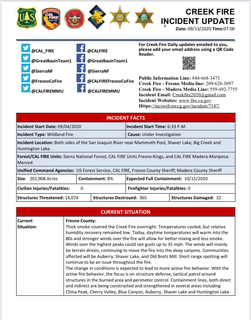
Update 5:45 A.M.: Sierra National Forest Creek Fire Operations Map for Sunday, September 13, 2020 - Shows Divisions, Uncontrolled Fire Edge, Completed Dozer Lines, Proposed Dozer Lines
September 13, 2020 - Overnight infrared mapping has the Creek Fire at 201,908 Interpreted Acres.
Comments and notes on flight:
Slight perimeter growth in similar areas as previous night. Central valley continues to cool.
Saturday Evening Update: 196,667acres and 8% containment, with 2,301 total fire personnel.
Sierra National Forest Creek Fire Updates for Saturday, September 12, 2020

