


 September 14, 2020 - CREEK FIRE REPOPULATION
WHAT: Evacuation Orders Reduced to Warning on the Creek Fire
DATE/TIME: Monday, September 14, 2020 at 2:00 P.M.
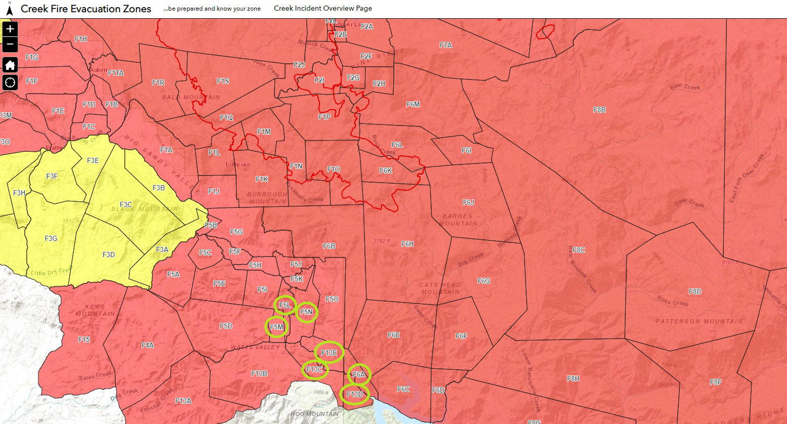
WHERE: Areas of repopulation in the following Zones
EVACUTATION ORDERS Reduced to WARNING:
Fresno County
The Following Evacuation Orders are Reduced to Evacuation Warning:
Zone F5L: The south boundary is Maxon Road. The west boundary is the end of the properties that lay on the west side of Watts Valley Road. The north boundary is the intersection of Watts Valley Road and Sycamore Road. The north boundary proceeds to the east to include the south side of Watts Valley Road. The east boundary is northwest of the intersection of Watts Valley Road and Maxon Road.
Zone F5M: The south boundary includes the north side of Watts Valley Road. The west boundary is the east side of Anderson Ranch Road. The north boundary is the property at the end of Anderson Ranch Road. The east boundary lays just west of the properties off of Watts Valley Road.
Zone F5N: The south boundary includes the north side of Maxon Road for half a mile east of its intersection with Watts Valley Road. The west boundary includes the east side of Watts Valley Road. The north perimeter lays south of the properties on the south side of High Mountain Lane.
Zone F6A: The south boundary is at the north side of Trimmer Campground. The west boundary includes the east side of Maxon Road and ends east of Vincent Fire Road.
Zone F13C: South boundary contains the properties south of Maxon Road south of Vincent Fire Road. The west boundary extends out to the east of the properties that lay on the east side of the Watts Valley Road and Maxon Road intersection. The north boundary contains properties on the south side of Maxon Road. The east boundary consists of the properties on the south side of Maxon Road about a half a mile west of the "Trimmer Work Center".
Zone F13D: South boundary consists of Trimmer Springs Road, about three quarters of a mile south of the "Trimmer Recreation Area". The west boundary extends about a half a mile west of the "Trimmer Work Center". The north boundary is north of Watts Creek. The east boundary contains properties on the west side of Maxon Road, west of Trimmer Springs Road.
Zone F13E: The south and west boundary consists of the east side of Maxon Road. The north boundary is just south of the intersection of Vincent Fire Road and Bob's Flat Trail. The east boundary extends to contain properties that lay on the east side of Vincent Fire Road.
To view the evacuation map please visit: https://nifc.maps.arcgis.com/apps/webappviewer/index.html?id=28ce52cb86bf49dea0adef5a78b3c1b5
Evacuation Order: Movement of community members out of a defined area due to an immediate threat to life and property from an emergency incident. An Evacuation Order should be used when there is potential or actual threat to civilian life within 1 to 2 hours or when the IC deems it necessary to protect civilians.
Evacuation Warning: Alerting of community members in a defined area of a potential threat to life and property from an emergency incident. An Evacuation Warning may be issued when the potential or actual threat to civilian life is more than 2 hours away.
SAFETY MESSAGE: The public is reminded to stay vigilant on current fire conditions. Please continue to adhere to road closures and evacuation orders or warnings. If you see electrical wires on the ground, stay clear and contact PG&E immediately. Power may be out when you return home. For those who may be utilizing backup generators, please review the generator use safety information at https://www.pge.com/en_US/safety/electrical-safety/electricgenerator-safety/electric-generator-safety.page?WT.pgeac=PSPS_FAQ-GeneratorSafety. Trees and poles with deep charring, particularly if still smoldering, should be considered hazardous. Please use caution in these areas, and obey all traffic control signs. Fire crews and utility companies will be remaining in the area in effort to mitigate any remaining fire concerns, restore utilities, and bolster infrastructure.
Please register for evacuation alerts by signing up at:
Fresno County: https://member.everbridge.net/index/453003085614497#/signup
Madera County: www.mcalert.org
Mariposa County: www.msoalert.com
For missing persons contact: Fresno County Sheriff 559-600-3111
Madera County Sheriff 559-658-2555
For more information on wildfire, visit CAL FIRE online at www.readyforwildfire.org
LINK for Spanish PDF
Source: CAL FIRE

