


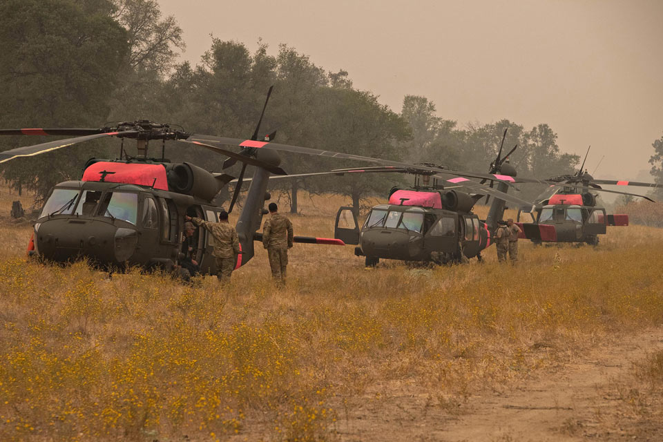
Three National Guard Blackhawk helicopters have been located to a temporary helibase in Auberry, CA. to assist in fighting the Creek Fire.
Credit: Tom Story, Great Basin IMT1 (Note: Not a Current Photo)
Note: No Current MODIS map of the Creek Fire for Friday
Note: 1,500 Wide and older yellow detections removed
MODIS Active Fire Mapping Program Frequently Asked Questions
Update for 7:30 P.M. CAL FIRE evening update: 248,256 acres and 22% containment, with 8,063 structures threatened.
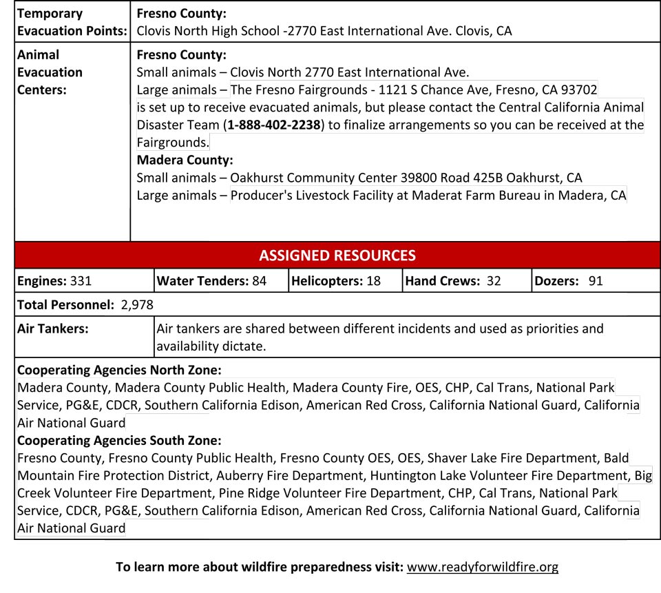
'Click' here to view 13 page PDF
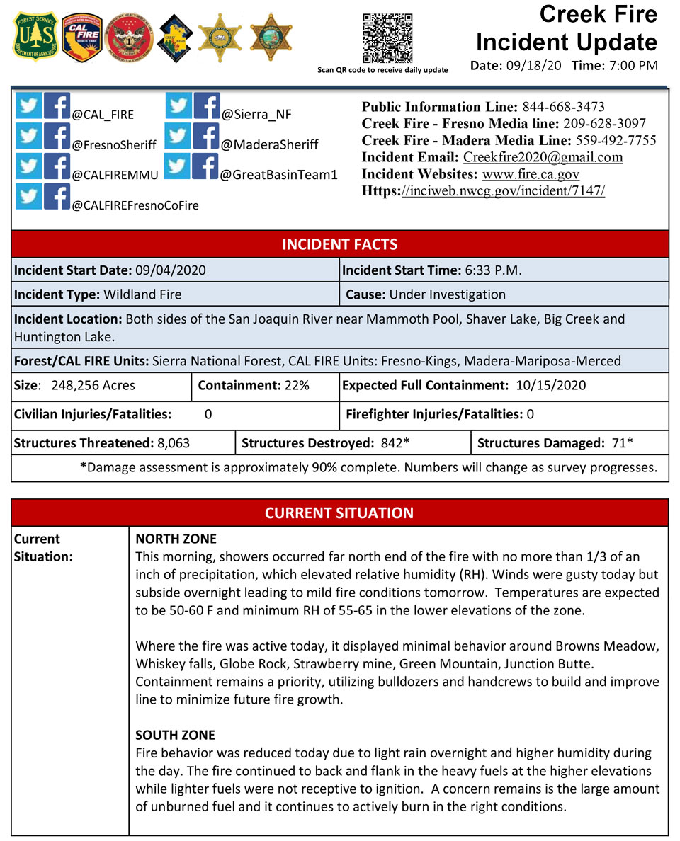
Update 7:00 P.M. (LIVE) The Creek Fire is now at 248,256 acres, with 22% containment.
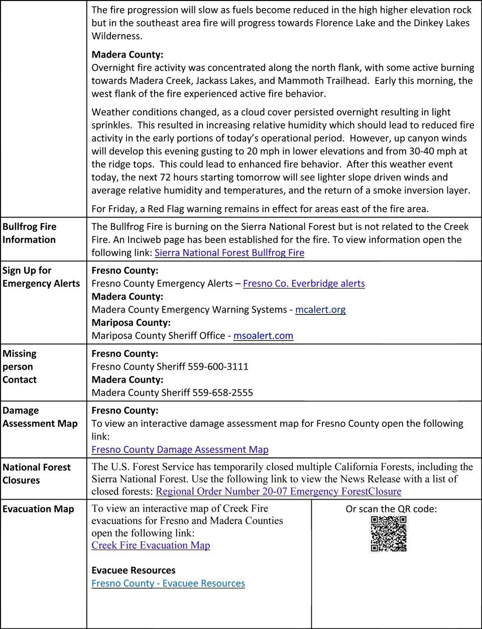
Sierra National Forest to Hold a Creek Fire Livestream Incident Briefing with CAL FIRE on Friday, September 18, 2020
Update 6:35 P.M. Sierra National Forest to Hold a Creek Fire Informational Update for the Mammoth Lakes Area on Saturday, September 19, 2020
Update 6:20 P.M. Per Madera County Sheriff’s Office: The Sheriff’s Office, in cooperation with the Madera County Road Department and the Chawanakee Unified School District, have placed dumpsters for spoiled food in North Fork for community use. The dumpsters are located at North Fork Town Hall at 33060 Road 228, North Fork, CA 93643.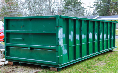
Update 5:45 P.M. Per Madera County Sheriff’s Office: Residents living in the Bass Lake Area, Road 225 Corridor, and Cascadel are encouraged to obtain an entry pass for faster access at the traffic control points. This will prevent Deputies from having to check identification at the traffic control points. There will be extra staff at the Oakhurst Substation (48267 Liberty Drive) on Saturday and Sunday from 8AM to 4PM to issue entry passes. You will need to bring your identification and proof of residence, as well as the make, model, color, and license plate of your vehicle.
Entry passes are not required for entry. Deputies will still accept other proof of residence at the traffic control points.
Update 3:05 P.M. Per Madera County Sheriff’s Office: Evacuation Warnings Lifted for M1, M29, M30, M47, & M46
Evacuation Warnings Lifted for M1, M29, M30, M46, & M47 The Madera County Sheriff's Office is pleased to announce the evacuation warnings for Evacuation Zones M1 Kerckhoff Lake, M29 south End of North Fork, M30 downtown North Fork, M46 Road 223, and M47 Timberview, have been lifted. Please go to the Madera County Web Page and click on the fire map to see more information.
Update 2:35 P.M. Per USFS: Some Creek Fire evacuation orders have been reduced to warnings & some warnings have been lifted. 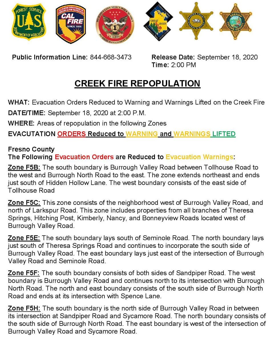
Update 2:05 P.M. Sierra National Forest to Hold a Creek Fire Livestream Incident Briefing with CAL FIRE on Friday, September 18, 2020
Update 10:45 A.M.: Sierra National Forest Creek Fire Operations South Zone Briefing Video for Friday, September 18, 2020
Update 10:15 A.M. Per Madera County Sheriff's Office: Evacuation Order Lifted M7
Evacuation Orders for M7 have been reduced to Evacuation Warnings. Residents in the area need to be aware there is still a potential for evacuations and need to be prepared to evacuate at a moments notice. Citizens need to monitor the situation and be prepared to take action immediately. These areas are being opened to residents only. Cascadel Road between Peckinpah Acres Drive and end of the subdivision including all spur roads such as Cascadel Heights Drive, GR Trestle Court, Loma Linda Drive, Loma Linda Lane, Vista Drive West, Hillside Road, Cascadel Drive, Cascadel Lane, Cascadel Drive North, Cascadel Drive South and Waterfall Way.
Update 10:10 A.M.: Sierra National Forest Creek Fire North Zone Operations Briefing Video For Friday, September 18, 2020
Update 9:45 A.M.: Forest Service Wildland Fire Smoke/Air Quality Outlook Due to the Creek Fire in the Yosemite Area for September 18 & 19, 2020
Update 9:15 A.M.: CAL FIRE morning update: 248,256 acres and 20% containment, with 8,611 structures threatened.
'Click' here to view 13 page PDF With Evacuations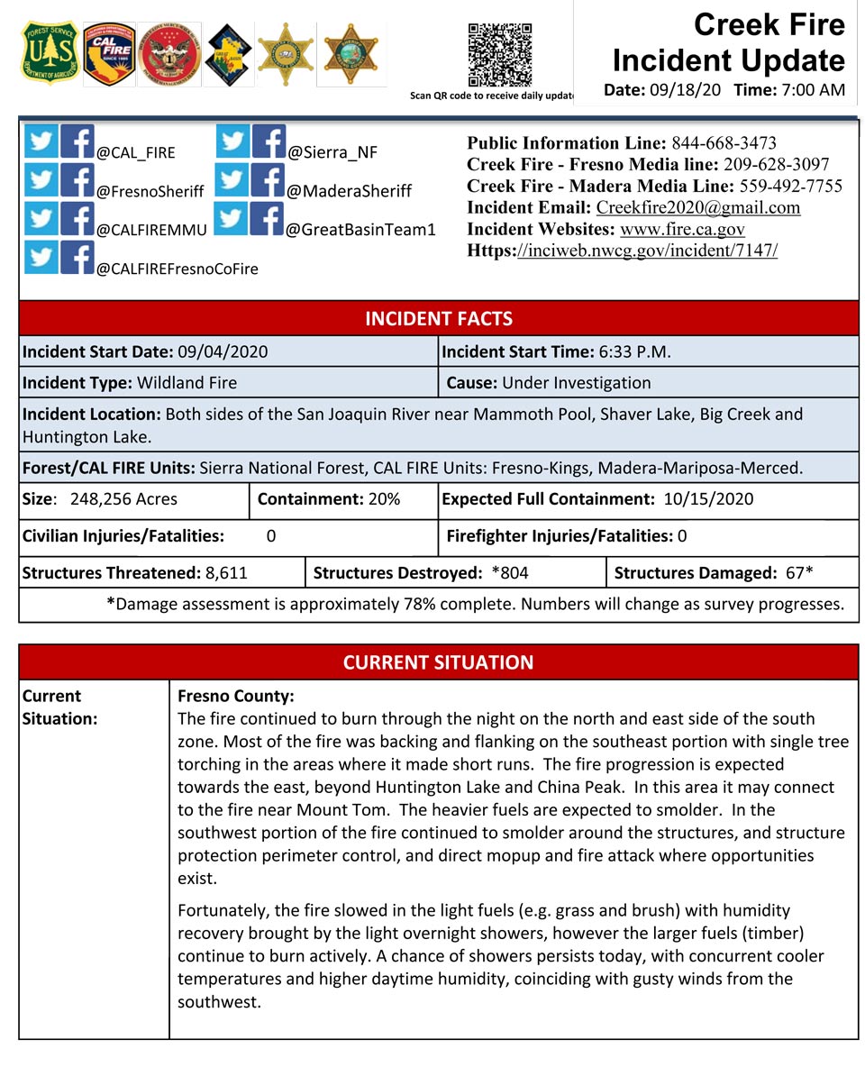
Operations Map has Acreage at 248,256
Update: 5:00 A.M.: Sierra National Forest Creek Fire Pilot Map for Friday, September 18, 2020 - Shows Divisions, Uncontrolled Fire Edge
September 18, 2020 - Looks like NO Overnight infrared mapping of the Creek Fire for Interpreted Acres.
Comments and notes on flight:
Thursday Evening Update: 246,756 acres and 20% containment.
Sierra National Forest Creek Fire Updates for Thursday, September 17, 2020

