


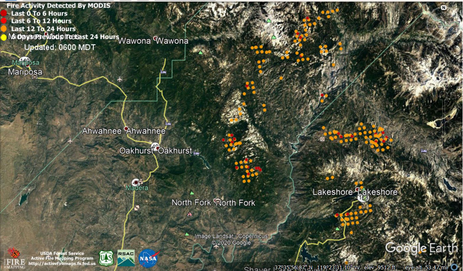
 MODIS map of the Creek Fire on Tuesday at 5:00 A.M. PST
Note: 1,500 Wide and older yellow detections removed
MODIS Active Fire Mapping Program Frequently Asked Questions
Update 7:05 P.M. CAL FIRE Evening Update: 286,519 acres and 32% containment, with 6,723 structures threatened.
'Click' here to view 13 page PDF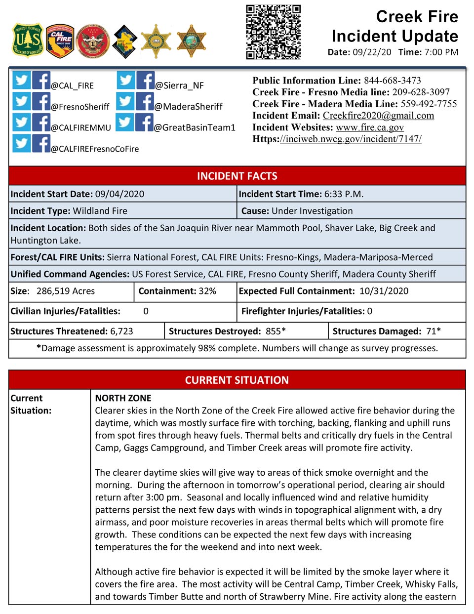
Update 7:00 P.M.: (LIVE) Sierra National Forest to Hold a Creek Fire Livestream Incident Briefing with CAL FIRE on Tuesday, September 22
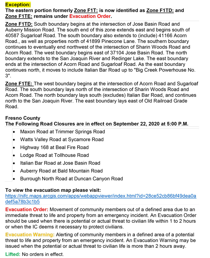
Update 5:00 P.M. Per CAL FIRE Evacuation Warnings Lifted: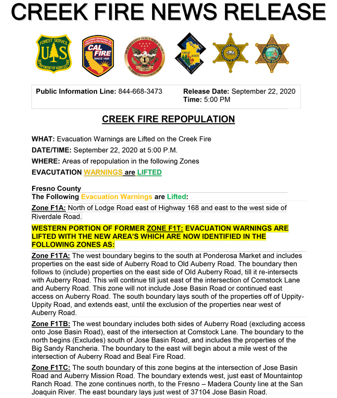
Update for 3:30 P.M. Per Madera County Sheriff’s Office: Evacuation Warnings Lifted for M20, M32, M26, M36, M37, M38, M54, M88, M89, and M90
The Madera County Sheriff's Office is pleased to announce the evacuation warnings for the following Evacuation Zones have been lifted. M20 Mill Site Area M32 Road 224 Area M26 Bass Lake Heights M36 Road 221 Area M37 Teaford Subdivision M38 Hidden Meadows M54 Old Corral Area M88 Yosemite Forks M89 Sky Ranch Subdivision M90 Cedar Valley Please go to the Madera County Web Page and click on the fire map to see more information.
Update 2:28 P.M.: Sierra National Forest to Hold a Creek Fire Livestream Incident Briefing with CAL FIRE on Tuesday, September 22, 2020
Update 10:55 A.M.: Forest Service Wildland Fire Smoke/Air Quality Outlook Due to the Creek Fire in the Yosemite Area for September 22 & 23, 2020
Update 10:45 A.M.: Sierra National Forest Creek Fire North Zone Operations Briefing Video For Tuesday, September 22, 2020
Update 10:10 A.M.: Sierra National Forest Creek Fire Operations South Zone Briefing Video for Tuesday, September 22, 2020
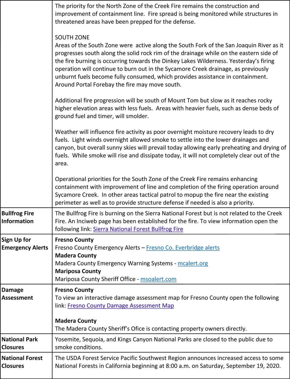
Update 8:05 A.M.: CAL FIRE morning update: 283,724 acres and 30% containment, with 7,759 structures threatened.
'Click' here to view 14 page PDF With Evacuations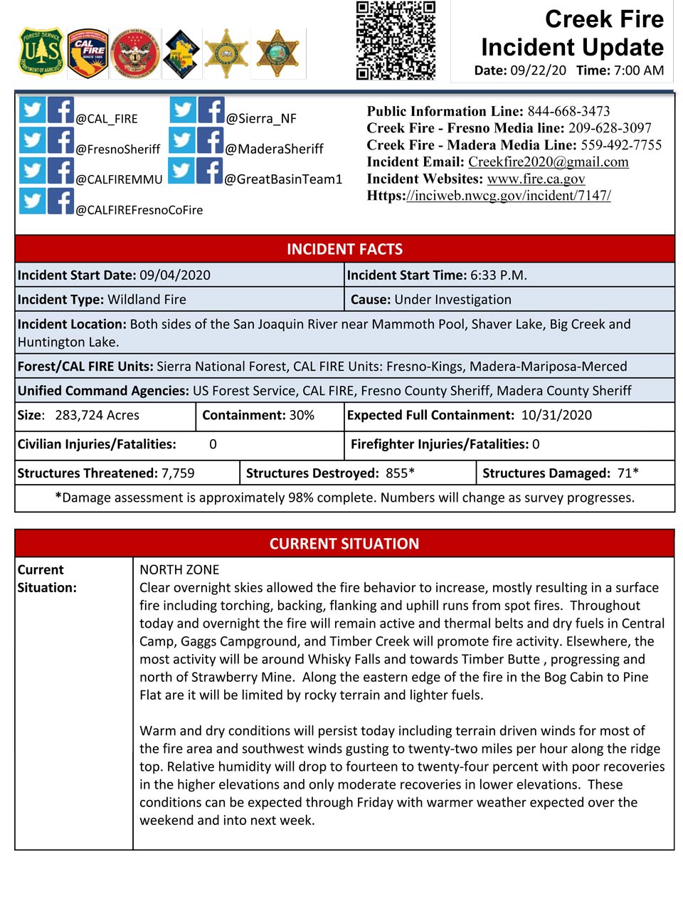
Update 6:45 A.M.: Sierra National Forest Creek Fire Operations Map for Tuesday, September 22, 2020 - Shows Divisions, Uncontrolled Fire Edge, Completed Dozer Lines, Proposed Dozer Lines
Update 6:05 A.M.: Sierra National Forest Creek Fire Public Information Map for Tuesday, September 22, 2020 - Shows Fire Perimeter and Containment
September 22, 2020 - Overnight infrared mapping has the Creek Fire at 283,724 Interpreted Acres.
Comments and notes on flight:
No data was received for the centraland easternmost portions of the fire. The perimeter in those areas is indicated as estimated.
Areas of growth with intense fire were detected along the northwestern, northern, northeastern and southern perimeters of the fire.
Additional areas of intense fire were detected within the northern and southernmost portions of the perimeter.
Extremely large areas of scattered fire essentially filled the northern portion of the perimeter.
Isolated fires were generally within fairly close proximity to the main perimeters.
A few isolated fires were detected at greater distances from the northeastern end of the fire.
Monday Evening Update: 280,425 acres and 30% containment.
Sierra National Forest Creek Fire Updates for Monday, September 21, 2020
