


California and National Drought Summary for October 13, 2020
Summary
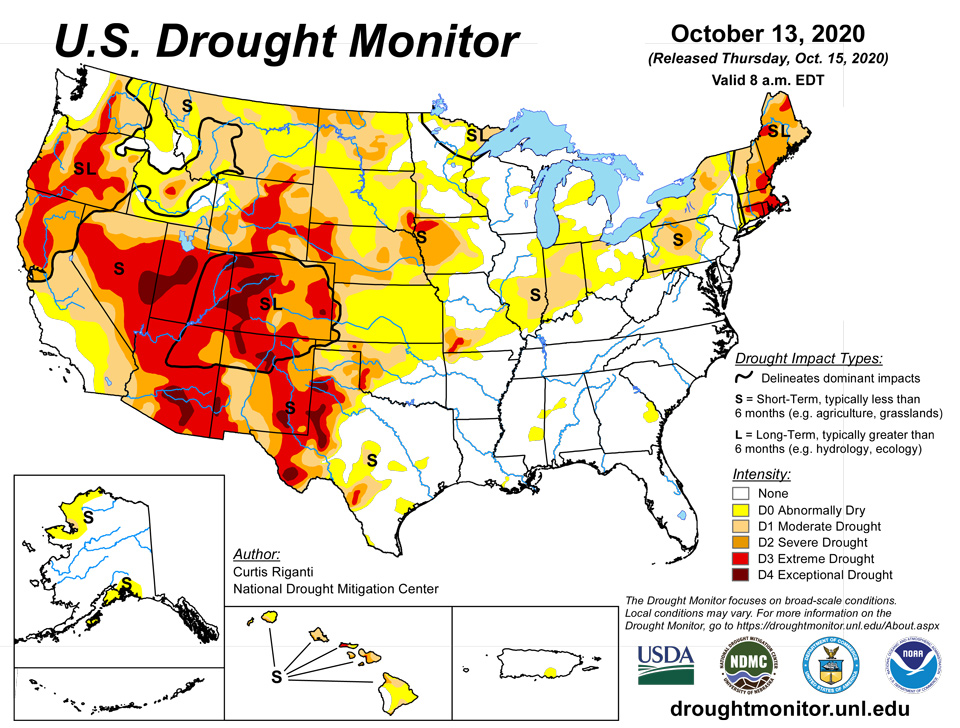
October 15, 2020 - A dry pattern continued this past week over large portions of the continental United States, with a few exceptions being areas impacted by Hurricane Delta or its remnants, parts of the Upper Midwest and middle Missouri River Valley, and parts of the Northeast. In areas of the Northeast that received an inch or two of rain, some improvements were made in the ongoing drought areas there. As a storm system and associated cold front brought showers and thunderstorms to parts of the Middle and Upper Missouri River Valley and to the Upper Midwest, some improvements were made to ongoing drought there. Abnormal dryness abated in a few areas of Louisiana and Mississippi, which received copious rainfall from Hurricane Delta. Degradations or persistence of ongoing drought was common in parts of the Midwest, Great Plains, and West that received little or no precipitation this week. Temperatures this week were warmer than normal across most of the Lower 48. The central Great Plains and middle Missouri River Valley were the warmest compared to normal, with temperatures from 9 to 12 degrees above normal common. New England experienced milder conditions this week, with a few below-normal readings taking place in northern Vermont, New Hampshire, and Maine.
West
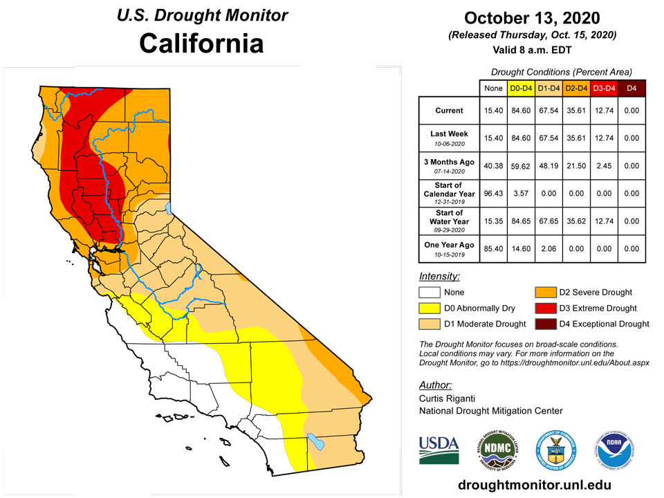
The West generally experienced warmer than normal temperatures again this week, with most areas coming in between 3 and 9 degrees above normal for the week. Generally, the southern half of the region stayed dry, while some precipitation occurred over the north, particularly in far northwest California, western Washington and Oregon, western Wyoming, and western portions of Montana and Idaho. Due to recent precipitation, extreme drought in western Oregon reduced in coverage. In southwest Oregon, where short- and long-term precipitation deficits were worsening, severe and extreme drought increased in coverage. Extreme drought also increased its foothold in west-central Nevada, where soil moisture profiles continued to worsen along with short- and long-term precipitation deficits.
High Plains
Drier than normal conditions continued across much of the High Plains region, where temperatures were also generally 6 to 12 degrees warmer than normal. Consequently, as short- and long-term precipitation deficits grew amid warmer than normal weather, and near surface moisture and agricultural impacts worsened, widespread degradation in drought conditions occurred. Moderate, severe, and extreme drought coverage increased across most of the region, with the exception of northeast Nebraska and adjacent portions of Iowa and South Dakota, where a storm system brought locally high amounts of rain. In the areas with highest rainfall, short-term precipitation deficits improved enough such that extreme and severe drought decreased in coverage.
Northeast
Outside of New England, temperatures were mostly near or several degrees above normal, while temperatures in New England were generally near normal or a few degrees cooler than normal. Rainfall from several storm systems led to above-normal rainfall in parts of northern New York, localized parts of northern New Hampshire and Vermont, and northern Maine. Elsewhere, rainfall was closer to normal or below normal. Severe drought decreased in coverage in parts Vermont and New Hampshire due to recent rainfall improving precipitation deficits. Meanwhile, severe drought increased in coverage in western Pennsylvania and New York, as short-term precipitation deficits worsened in tandem with decreasing streamflow and soil moisture.
Southeast
The primary weather-maker over the past week was Hurricane Delta, which made landfall in southwest Louisiana as a category two hurricane, and its remnants. Rainfall from Delta was widespread over the region, though a few places, such as scattered parts of southeast Georgia and Florida, saw more spotty rainfall. No drought existed at the beginning or end of the period in the region, though a few areas of abnormal dryness were erased or shrank in size due to Delta’s rainfall. Temperatures were above normal across the entire region, with the warmest conditions (compared to normal) taking place in the Florida Panhandle, southern Alabama, and southern Georgia, where temperatures ranging from 6 to 12 degrees above normal were common.
South
Category two Hurricane Delta and its remnants delivered above-normal rainfall from far east Texas through most of Mississippi, southeast Arkansas, and southern Tennessee, leading to the reduction of abnormally dry areas in Louisiana and Mississippi. Elsewhere, dry conditions occurred, and existing areas of drought expanded. Short-term drought continued to plague the southern high plains regions of Oklahoma and Texas, where moderate, severe, and extreme drought continued to spread amid worsening short-term precipitation deficits, decreasing soil moisture, and drying vegetation. Temperatures in the region were also mostly warmer than normal, with the warmest areas (compared to normal) being found in the Oklahoma and Texas panhandles, where temperatures were 9 to 12 degrees warmer than normal.
Alaska, Hawaii, and Puerto Rico
No changes were made to the drought depiction in Alaska or Puerto Rico this week. In Hawaii, worsening pasture conditions on Kauai led to degradation to severe drought in the southwest. On Oahu, moderate drought developed over the windward slopes, where water consumption reductions were requested.
Midwest
Temperatures were warmer than normal in the Midwest this week, with the warmest readings (9 to 12 degrees above normal) taking place in Missouri, Iowa, and southwest Minnesota. Widespread rain of a half inch or more, with localized areas receiving 1-2 inches, fell from northwest Iowa through most of Minnesota, northern Wisconsin, and Michigan (excluding the far southern Lower Peninsula). Rain over a half inch also fell in the southeast half of Kentucky. Elsewhere, rainfall was generally scattered and light. Moderate drought developed in the St. Louis area, where short-term precipitation deficits grew amid warmer than normal temperatures. Severe and extreme drought grew in size in southwest Missouri as short-term precipitation deficits worsened. Moderate drought also increased in coverage in parts of Illinois and Indiana as short-term precipitation deficits grew and soil moisture decreased. Due to recent rainfall, severe and extreme drought conditions improved in far northwest Iowa, and moderate drought was reduced in coverage near the Minneapolis-St. Paul area.
Pacific Islands
This week was wet in the Republic of Palau, with the Palau IAP reporting 6.21 inches of rain and the Koror COOP station reporting 4.85 inches (with one day missing). Monthly totals (through October 13) were near to above the monthly minimum (8 inches) needed to meet most water needs – 10.85 inches at Palau IAP and 7.34 inches at the Koror COOP station. With recent weeks and months wet, D-Nothing continued at Palau.
The Marianas have also been wet, with Guam reporting 7.54 inches of rain this week, Rota 3.41 inches, Dededo 6.23 inches, and Tinian 2.16 inches. Saipan IAP recorded 2.07 inches and the Saipan ASOS station had 1.23 inches, but the Saipan NPS station recorded only 0.35 inch. With most stations wet (more than the weekly and monthly minimum needed to meet most water needs, 1 inch and 4 inches, respectively) the last couple weeks and last couple months, D-Nothing continued in the Marianas.
The week was dry across southern portions of the Federated States of Micronesia (FSM) and bands across the eastern and western portions. A third of an inch, or less, of rain fell in the south at Kapingamarangi (0.03 inch) and Nukuoro (0.35); less than an inch was recorded at Ulithi (0.37) and Woleai (0.93); and less than the 2-inch weekly minimum was reported at Pingelap (1.76). Based on precipitation data through the end of September, Kapingamarangi had the driest to fourth driest time period on record for the 12 time periods from September to October-September. These included the driest August-September and May- September through December- September; second driest July- September, June- September, and November- September; third driest October- September; and fourth driest September. Only 0.86 inch of rain fell in September, 0.46 inch has fallen so far this month (through October 13), and only 0.03 inch has fallen this week. Rain fell on every day from August 1-11, then it was like nature turned off the faucet. Only 16 days in the last 63 days have had measureable rainfall, and of those only five had more than a tenth of an inch, only two were more than a fourth of an inch, and none were more than half an inch. As noted in the October 2 NWS Drought Information Statement, community water tanks are being tapped. As of September 30, only three of the six community water tanks are full (2 tanks are empty and 1 tank is 1/4 full). Observers estimate that the remaining community water supply will last them about 1.5 months with no additional rainfall. Vegetation is mostly brown with no banana or breadfruit left. Taro crops are still producing. That was two weeks ago. With little rain since then, conditions are likely worse now. Kapingamarangi was changed from D3-S to D4-S on this draft.
Elsewhere in the FSM, the week was wet (more than the 2-inch weekly minimum needed to meet most water needs). For the wet stations, weekly rainfall totals ranged from 2.08 inches at Yap and 2.90 inches at Fananu to 4.86 inches at Mwoakilloa and 5.94 inches at Lukonor. With this week wet, and previous weeks or months wet, D-Nothing continued at the rest of the FSM stations.
The week was wet in the Marshall Islands. Precipitation totals ranged from 2.17 inches at Kwajalein to 6.89 inches at Ailinglaplap. Utirik was missing as there was no weather observer. With 4.80 inches of rain falling this week, and 5.93 inches for the month so far, the status at Jaluit was changed from D0-S to D-Nothing. Even though 2.34 inches of rain fell this week, D1-SL continued at Wotje as the status was changed from D2-SL to D1-SL last week. D-Nothing continued at the rest of the RMI stations.
The week was wet in American Samoa with Pago Pago reporting 3.91 inches and the automated station at Toa Ridge 2.32 inches. Monthly totals were well above the 4-inch monthly minimum needed to meet most water needs – 7.00 inches at Pago Pago and 4.08 inches at Toa Ridge. The last several weeks and months have been wet, so D-Nothing continued at Tutuila.
Virgin Islands
Radar-based estimates of rainfall for the 7 days ending at 12z on Tuesday depicted half an inch to an inch or more of rain across parts of St. John and St. Thomas, while St. Croix generally had less than half an inch.
CoCoRaHS and National Weather Service (NWS) station reports of rainfall totals for the week on St. Croix ranged from 0.22 inch at Frederiksted 2.3 N to 0.75 inch at Frederiksted 0.5 N. For those stations that have normals, these were all below the weekly normal rainfall. But the previous week was much wetter. For those stations with no missing days, precipitation totals for October 1-13 ranged from 1.65 inches (Frederiksted 0.5 N) to 2.41 inches (Christiansted 1.6 E). The Standardized Precipitation Index (SPI) values for Rohlsen AP and East Hill at 1- and 3-month time scales were still wet or not D0 (abnormally dry) yet. The 12-month SPI continued at D1 (moderate drought) status. Since last week was wet, the SPI values are mostly not abnormally dry, and it still rained some this week, the USDM status continued at D-Nothing for St. Croix.
CoCoRaHS and NWS station reports of rainfall totals for the week on St. Thomas ranged from 0.07 inch at Charlotte Amalie 1.4 NE to 0.85 inch at King AP. For those stations that have normals, these were all below the weekly normal rainfall. But the previous week was much wetter. For those stations with no missing days, totals for October 1-13 ranged from 1.55 inches (Charlotte Amalie 1.4 NE) to 2.49 inches (King AP). The SPI values for King AP at 1- and 3-month time scales were still wet. Longer time scales (6 and 12 months) were barely at D0 status. Since last week was wet, the SPI values are mostly not abnormally dry, and it still rained some this week, the USDM status continued at D-Nothing for St. Thomas.
CoCoRaHS and NWS station reports of rainfall totals for the week on St. John ranged from 0.31 inch at Windswept Beach to 0.70 inch at Cruz Bay 1.6 E. For those stations that have long records (Windswept Beach), the weekly value was well below the long-term average for the week. But the previous week was much wetter. For those stations with no missing days, totals for October 1-13 ranged from 1.71 inches (Windswept Beach) to 2.54 inches (Cruz Bay 1.6 E). The SPI value for Windswept Beach just turned abnormally dry this week at the 1-month time scale, and 6- and 9-months are at D1 status, but 3-month SPI is still not D0 yet. Since last week was wet and it still rained some this week, the USDM status continued at D-Nothing for St. John. But with most time scales having an SPI of D0 or D1, St. John will be watched for the return of D0 if the coming weeks are dry.
Looking Ahead
A series of cold fronts over the next week are forecast to bring a higher chance of cooler than normal temperatures to the north-central continental United States. With the exception of the northern tier of states, much of the West is forecast to be dry through the evening of October 19. Farther east, higher rainfall amounts of a half an inch or more are possible from the Mid-Atlantic coast north, while lighter precipitation is forecast in the Midwest. Glancing ahead to the October 20-24 period, cooler than normal conditions are more likely to be widespread from the Pacific Northwest to the western Great Lakes, while in the eastern United States, warmer than normal temperatures are favored in this period. Widespread increased chances for above-normal precipitation are forecast in the northern Rockies and much of the Great Plains, Midwest, and East, while below-normal or near-normal precipitation is favored elsewhere in the Lower 48.
Author(s):
Curtis Riganti, National Drought Mitigation Center
Richard Heim, NOAA/NCEI
Dryness Categories
D0 Abnormally Dry—used for areas showing dryness but not yet in drought, or for areas recovering from drought.
Drought Intensity Categories
D1 Moderate Drought
D2 Severe Drought
D3 Extreme Drought
D4 Exceptional Drought
Drought or Dryness Types
S Short-Term, typically less than 6 months (e.g. agricultural, grasslands)
L Long-Term, typically greater than 6 months (e.g. hydrologic, ecologic)
Source: National Drought Mitigation Center

