


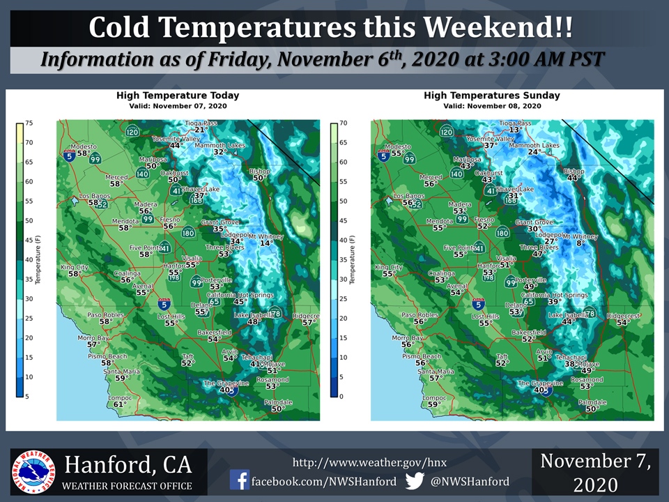
Mariposa High Temp for Saturday 50 Degrees and Sunday 43 Degrees
Oakhurst High Temp for Saturday 50 Degrees and Sunday 43 Degrees
Yosemite Valley High Temp for Saturday 44 Degrees and Sunday 37 Degrees
  Area Forecast Discussion
  National Weather Service Hanford CA
  358 AM PST Sat Nov 7 2020


  .SYNOPSIS...Rain and mountain snow is expected across the entire
  district through the weekend as the first major storm system
  affects the area. High temperatures throughout next week will
  remain below normal


  &&

  .DISCUSSION...Light showers are beginning to move into the west
  and northern half of the district this morning as a 541 decameter
  500mb low continues to dig into central California. Strong winds
  developed today as a cold front pushed through the region. This
  front finally helped clear out the valley of all of the smoke and
  haze that has plagued the area for what feels like forever.

  Precipitation will continue to spread toward the east and southeast
  across the valley and into the mountains today. The greatest
  accumulations will stay mostly south of Fresno county, although
  some light accumulations area still possible into the northern
  half of the district. The Kern county desert will also have a
  chance of showers by later this morning, but precipitation amounts
  will remain light. Outside of a few lingering showers later this
  afternoon and evening in the higher elevations of the Sierra and
  Kern Co. mountains, there will be a lull in the precipitation
  through Sunday morning. Temperatures will be well below average
  today as a cold airmass moves into the area. Many locations in the
  valley and desert will struggle into the mid 50s. Snow levels in
  the mountains will also continue to fall to around 5,000 feet by
  the afternoon.

  Another trough of low pressure currently in the PacNW will dig
  southward later tonight into Sunday. Since this trough is closer
  to the Sierra range, it will have more moisture compared to
  today`s system. Guidance has continued to pick up on this solution
  and as such, overall QPF amounts for Sunday`s system are slightly
  greater. This system is also very cold, and snow levels will
  continue to fall to around 4,000 feet, which will bring the
  threat of accumulating snowfall down to pass levels. A Winter
  Storm Warning will remain in effect for the southern Sierra Nevada
  through Sunday evening, where general amounts of 3 to 6 inches
  are possible between 4,000 to 6,000 feet. Between 6 to 12 inches
  with locally higher amounts are possible above 6,000 feet by
  Sunday evening. Snowfall will eventually spread into Kern county
  by the morning, and will continue into Sunday evening. Snowfall
  will be possible through both the Grapevine and Tehachapi passes
  on Sunday, where a trace to 2 inches is possible. Greater amounts
  are expected above 6,000 feet. A Winter Weather Advisory will be
  in effect for the Kern Co. mountains through Sunday evening.

  This storm system will exit the region by Monday, leaving a very
  cold airmass in its wake. Low temperature in the valley could
  reach into the lower 30s, with low to mid 20s in the desert. Since
  it is the first decent rain in the valley, fog may become an issue
  for both Sunday and Monday mornings, but confidence is still low.

  The region will remain under a cooler northwesterly flow for the
  majority of next week as a general trough pattern remains over
  the western U.S. Afternoon high temperatures across the central
  California interior will slightly moderate through the upcoming
  week, however they are expected to remain slightly below average.
  Models are starting to hint at the possibility of another system
  reaching the area by next weekend. So cooler temperatures, chances
  of rain and snow across the region, finally something to talk
  about other than fires and smoke!
Source: NWS

