


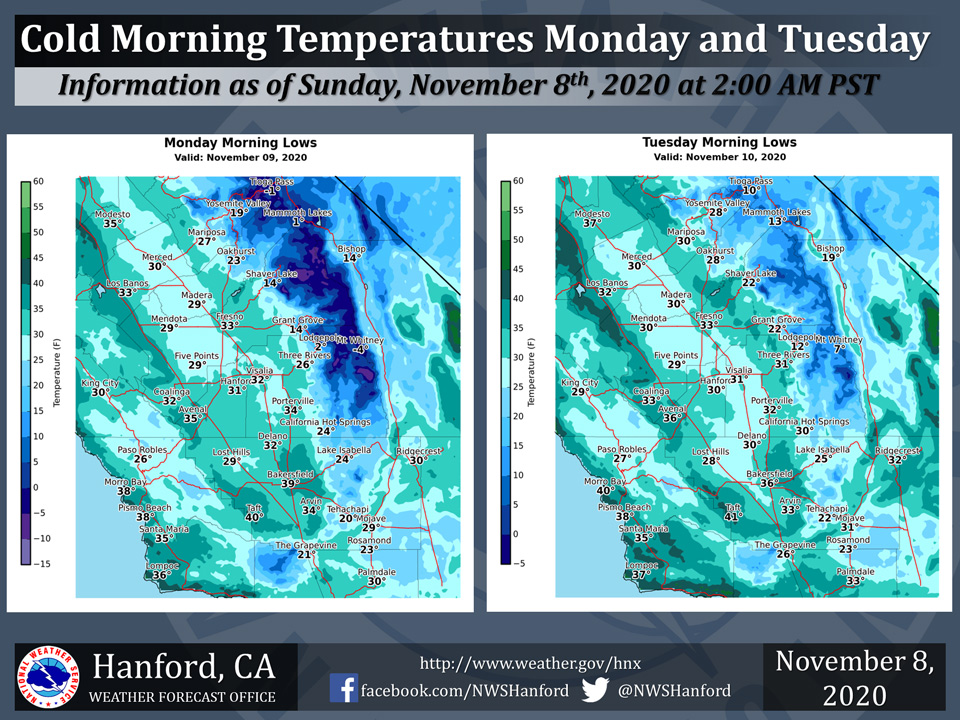
Mariposa Low Temp for Monday 27 Degrees and Tuesday 30 Degrees
Oakhurst Low Temp for Monday 23 Degrees and Tuesday 28 Degrees
Yosemite Valley Low Temp for Monday 19 Degrees and Tuesday 28 Degrees
November 8, 2020 - The National Weather Service Hanford Office reports morning low temperatures will fall below freezing for nearly all of the Kern Co. desert and southern San Joaquin Valley on Monday and Tuesday.
Outside of major urban areas, sub-freezing temperatures are conceivable for a period of four to six hours.
Be prepared to bring pets indoors and cover sensitive, exposed vegetation, and outdoor plumbing.
  Area Forecast Discussion
  National Weather Service Hanford CA
  319 AM PST Sun Nov 8 2020

  .SYNOPSIS...
  Rain and mountain snow is expected across the entire region today
  and tonight with the first major storm system of the season
  impacting the area. Low temperatures will drop below the freezing
  mark in the Kern County Deserts on tonight and into Monday,
  Tuesday and Wednesday mornings. Temperatures will remain below
  normal next week. Another system will impact mainly the Sierra
  Thursday night and Friday.

  &&

  .DISCUSSION...
  The first taste of winter is upon us! Sierra snow and valley rain
  are a welcomed sight to many of us here in the central California
  region. Clean air and cool temperatures are also very nice.
  Hopefully we will get enough precip to put a damper on the Creek
  and SQF Complex fires in the Sierra. The first cold core went
  through the region Friday night and into Saturday morning,
  bringing some light precip to a lot of the area. We had a lull in
  the action during the day on Saturday. We are now seeing on
  regional radar and satellite loops that precipitation is picking
  up once again across the Sierra attm.

  Another mid level disturbance will drop down the backside of the
  low that went through yesterday and bring a round of moderate to
  possibly heavy snow at times across the Sierra today and this
  evening. Some light rain is also possible in the San Joaquin
  Valley today as well. Unseasonably cold temperatures associated
  with the system will make it feel a lot like winter today with
  periods of light rain and temps in the lower 50s across most of
  the SJV. As mentioned earlier, moderate to heavy snow is expected
  across the Sierra today and tonight. Snow levels will drop down to
  around 4000 feet later this afternoon. This could impact the
  Grapevine along the interstate 5 corridor through the Tehachapi
  mountains in Kern County. Snowfall amounts are expected to be up
  to 2 inches at pass level later today. Snow amounts are expected
  to be around a foot above 4000 feet across the Sierra today. The
  heaviest snow is expected this morning into early afternoon. We
  could see 1 to 2 inches of snow per hour for several hours today
  as the cold core moves through.

  The cold core will swing through the area late tonight with
  clearing conditions by Monday. However it will leave a very cold
  airmass in its wake and we will see very cold temperatures across
  the area tonight and Monday night. Below freezing temperatures
  are expected across the SJV Monday and Tuesday mornings and even
  possibly on Wednesday morning. We have issued a Freeze Warning for
  both days for the SJV and a Hard Freeze Warning for the Kern
  county desert. Local policy is that we only issue one Hard Freeze
  Warning for the desert and then no longer issue anymore. We do not
  issue any Freeze Warnings for the desert area, only Hard Freeze
  Warnings.

  Dry conditions are expected Monday through Thursday with a
  gradual warming trend. A cold front will drop south into Merced
  County Thursday night and move south across central California on
  Friday with light showers in the valley and light snow in the
  Sierra. Initial forecast snow amounts are up to 4 inches in the
  Sierra, mainly near Yosemite. Just a few hundreths of rain are
  possible in the SJV. Clearing conditions behind the front on
  Saturday and continuing on Sunday with a gradual warming trend
  expected.
Source: NWS

