


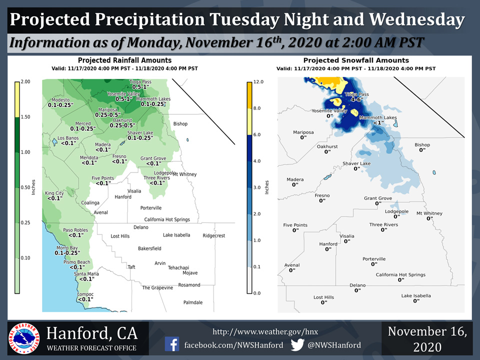
Projected rainfall totals for Mariposa: 0.25" to 0.50"
Projected rainfall totals for Oakhurst: 0.25" to 0.50"
Projected rainfall totals for Yosemite Valley: 0.50" to 1.00"
November 16, 2020 - The National Weather Service Hanford Office reports a cold front will pass through Central California Tuesday night into Wednesday.
Precipitation chances ahead of and along this cold front will be highest from Fresno County northward.
The majority of this projected precipitation will fall between 10 PM PST Tuesday night and 10 AM PST Wednesday morning.
  Area Forecast Discussion
  National Weather Service Hanford CA
  330 AM PST Mon Nov 16 2020

  .SYNOPSIS...
  A warming trend is expected today and Tuesday. By Tuesday
  afternoon, high temperatures will be well above normal for this
  time of year. A cold front will pass through Central California
  Tuesday night into Wednesday. Rain and high elevation snow is
  possible Tuesday night and Wednesday, primarily north of Tulare
  County. A cooling trend is expected Thursday and Friday.

  &&

  .DISCUSSION...
  Areas of fog are likely in the San Joaquin Valley early this
  morning. There may be patchy, dense fog in some spots, but the fog
  will not nearly be as widespread as Saturday night/early Sunday
  morning. A repeat of mist and fog is probable in the San Joaquin
  Valley once again tonight. A ridge of high pressure will build
  northwestward across Southern California today. This ridge of high
  pressure will move eastward tonight and Tuesday. A warming trend
  will take place today and Tuesday. By Tuesday afternoon, maximum
  temperatures will be around ten degrees above normal for this time
  of year.

  A cold front will sweep through Central California Tuesday night
  into Wednesday. Precipitation associated with this cold front
  should remain north of Tulare County Tuesday night and Wednesday.
  Total snow amounts of six to twelve inches are likely in the
  Mariposa County portion of the Sierra Nevada above 7,000 feet
  Tuesday night and Wednesday. A Winter Weather Advisory is in
  effect for the Mariposa, Madera, and northern Fresno County
  portion of the Sierra Nevada above 7,000 feet Tuesday night and
  Wednesday. Winds may gust as high as 55 mph on exposed ridgetops
  and along the crest, resulting in tree damage. Below the snow
  line, one quarter of an inch to one half of an inch of rain is
  expected in the Mariposa and Madera County foothills. In the San
  Joaquin Valley, rain amounts will generally be under one tenth of
  an inch from Fresno County northward.

  Zonal flow aloft will prevail over the northern half California
  Thursday. A secondary trough of low pressure may pass through
  Central California Thursday night or Friday. A cooling trend is
  expected Thursday and Friday. By Friday afternoon, high
  temperatures will be two to four degrees below their typical
  values for the latter half of November. A low amplitude ridge of
  high pressure will progress eastward through the Eastern Pacific
  Ocean Friday night through Saturday night. This ridge of high
  pressure will move over the Golden State Sunday. Temperatures
  this weekend will be near seasonal values.
Source: NWS

