


California and National Drought Summary for December 1, 2020
Summary
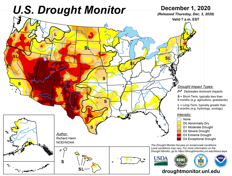
December 3, 2020 - A couple Pacific weather systems, in the form of shortwave troughs or closed lows, moved in the jet stream flow across the contiguous U.S. (CONUS) during this U.S. Drought Monitor (USDM) week. The weather systems brought rain or snow to the coastal Pacific Northwest, dried out as they traversed an upper-level ridge over the West, then picked up Gulf of Mexico and Atlantic moisture as they moved across the southern Plains to East Coast. An inch or more, with locally over 3 inches, of precipitation fell over the coastal and Cascade ranges, with up to an inch over parts of the northern Rockies. Otherwise, most of the West was dry. Only a few areas in the Northwest and southern Rockies had more than a quarter inch of precipitation. East of the Rockies, bands of an inch or more of precipitation, with locally 2 inches or more, fell across Kansas to the Great Lakes and along the Ohio River to northeast Ohio. Widespread 2+ inches of rain fell from coastal Texas to the Carolinas, and from Virginia to New England. A large shield of half an inch or more of precipitation surrounded these bands and extended from the southern and central Plains to the East Coast, and from the southern Great Lakes to Gulf of Mexico Coast. Generally the 1+ inch bands of precipitation were wetter than normal, while the areas with less than that were below normal. Much of the northern Plains to Upper Mississippi Valley was dry. Improvement in drought conditions occurred where precipitation was above normal, while drought expanded or intensified in some areas where dryness continued. Temperatures were near to cooler than normal across much of the West, southern Plains, and Lower Mississippi Valley, and warmer than normal in the northern Plains, South Texas, Great Lakes, Gulf Coast, and East Coast. Maps of 7-day, 14-day, and 28-day USGS streamflow measurements are consistent in showing below-normal streamflow from northern California, Nevada, and southern Idaho to the Four Corners states; and across southwest Nebraska to western Texas. They consistently show below-normal streamflow over central Texas, central Illinois to northern Indiana, and western Pennsylvania to western New York. The satellite-based Vegetation Health Index shows stressed vegetation across the California valleys and southern California, the Southwest, parts of the central Plains and Ohio Valley, and especially in southeastern New Mexico to western Texas. Where VegDRI is still in season, it shows drought across the Southwest and west Texas and parts of the Northeast (Maine). Where QuickDRI is still in season, it shows very dry conditions from southeastern Wyoming and western Nebraska, southward across Colorado, New Mexico, and western Kansas. The KBDI shows significantly dry conditions in California, Nevada, Utah, Arizona, New Mexico, and Texas, and a few spots in eastern Wyoming, western Nebraska, northern Florida, southern Alabama, and southern Georgia. NIFC maps show large wildfires still burning in California, and several in Oklahoma, central Appalachians, and a few elsewhere. Evapotranspiration (EDDI) for the last week has been high in California and the Southwest to the southern Plains, in the northern Plains, and in southern Alabama and Georgia. The EDDI shows high evapotranspiration across California and the Southwest, Great Plains, and Southeast to Northeast at the 2- to 3-week time scales, and across much of the West and Plains, Midwest, and Northeast at the 1- to 9-month time scales. USGS real-time groundwater level data show low groundwater at points across the West, in northern Indiana, southern Georgia, and parts of the Northeast, and a couple gauges in southern Alaska. NASA GRACE satellite-based groundwater estimates show low groundwater across most of the West to central and southern High Plains, most of New York to New England, much of Texas, and parts of North Dakota, Pennsylvania, Virginia, Alabama, Georgia, and Florida. Soil moisture is dry across the West from California to the southern and central Rockies, in the southern and central High Plains (especially southwest Nebraska and northwest Kansas), in North Dakota, across Nebraska and Iowa, across central Illinois to northern Indiana, parts of Pennsylvania and New York, and (for some indicators) most of New England (CPC, NLDAS, UCLA/VIC models; satellite-based AAFC/SMOS, GRACE, NASA/SPoRT analyses). SNOTEL snowpack (SWE percentiles) is above normal in Washington, Oregon, the Sierra Nevada, and parts of the other western states, but it is below normal across much of Utah and other parts of Idaho, Montana, Wyoming, Nevada, Colorado, and New Mexico. But this is early in the snow season and normal amounts are low. The Standardized Precipitation Index (SPI) shows dry conditions in various places at different time scales. These include North Dakota to Wyoming, northeast Texas to the Tennessee Valley, and parts of the West (at the 1-month time scale); California to the central and southern Rockies, much of the Great Plains, northern Missouri to northern Indiana, and parts of the Northeast (2 to 4 months); California to the central and southern Rockies, much of the Great Plains, Iowa, northern Indiana to Ohio and Michigan, most of Northeast (6 to 12 months); parts of Pacific Northwest (9 to 12 months); and the Southwest to southern and central High Plains, and parts of Pacific Northwest, Texas, Iowa, Indiana, and the Northeast (24 months). When the desiccating effects of hot temperatures are included, the Standardized Precipitation Evapotranspiration Index (SPEI) shows more intense drought conditions over the SPI dry areas than indicated by the SPI.
Northeast
Two inches or more of precipitation fell across a large part of New England this week, with other parts of the Northeast receiving half an inch or more. Abnormal dryness to extreme drought contracted in New England, moderate drought contracted in New York, and severe drought disappeared in Pennsylvania. According to U.S. Department of Agriculture (USDA) reports, 79% of the topsoil moisture in New Hampshire continued to be short or very short (dry to very dry).
Southeast
Half an inch or more of rain fell across northern Florida and all of the rest of the Southeast states. The swath of 2+ inches brushed the abnormally dry areas of Alabama and Georgia, contracting them.
South
Western parts of Texas remained dry this week, while half an inch or more of rain fell across the rest of the region. Two inches or more fell across parts of southern Texas to Mississippi. Abnormal dryness to exceptional drought contracted in southern Texas, abnormal dryness shrank in Louisiana and Mississippi, and moderate drought was reduced in Arkansas. But moderate to extreme drought expanded in other parts of Texas which were drier than normal for the week, and exceptional drought grew in west Texas. Abnormal dryness and moderate drought expanded in northern Mississippi and western Tennessee where this week’s rainfall was below normal. According to USDA reports, topsoil moisture was short or very short across 61% of Texas, 43% of Oklahoma, and 20% of Mississippi; 34% of the winter wheat was in poor to very poor condition across Texas.
Midwest
Abnormal dryness and moderate drought contracted in southern parts of the Midwest which received beneficial above-normal precipitation, especially in Illinois and Indiana. But in northern parts, where the week continued dry, abnormal dryness and moderate drought expanded, especially in Minnesota. USDA statistics show that 40% of the topsoil moisture was short or very short in Iowa.
High Plains
Central and eastern parts of Kansas, and strips in northeast and southeast Nebraska, received half an inch or more of precipitation, with over 2 inches falling in northeast Kansas. Parts of Colorado also received above-normal precipitation. But the rest of the High Plains region was dry. Moderate to severe drought shrank in southeast Nebraska and northeast Kansas, but moderate to severe drought expanded in parts of the states from North Dakota to Kansas. Extreme drought expanded slightly in southwest Kansas and was introduced in central North Dakota. Exceptional drought shrank slightly in central Colorado. According to USDA reports, half to two-thirds of the topsoil moisture was short to very short in all of the High Plains states except Colorado, where 83% of the topsoil moisture was short to very short. USDA statistics show that 38% of the winter wheat was in poor to very poor condition in Colorado. In Nebraska and Kansas, the winter wheat statistics were 26% and 22%, respectively, poor to very poor. Nationwide, the U.S. winter wheat condition index was the lowest since 2012.
West
Even though over 2 inches of precipitation fell locally in the coastal Pacific Northwest, it was still below normal. Only small parts of Montana, Arizona, and New Mexico were wetter than normal this week. The rest of the West had little to no precipitation, or what precipitation that fell was below normal. Abnormal dryness contracted in parts of Washington and northern Idaho where the indicators reflected improving conditions in recent weeks, and drought improved in a few parts of Oregon and worsened in other parts. Severe to exceptional drought expanded in Utah, with exceptional drought expanding in parts of Nevada, Arizona, and Colorado. Extreme and exceptional drought expanded in parts of New Mexico. Parts of northeast Nevada received precipitation this USDM week, but it was still below normal. The failure of the summer monsoon resulted in record dryness to the Southwest states, and record heat over warm season increased evapotranspiration, resulting in record SPEI values over the last 3 to 6 to 9 months. The SPEI values were not only record, they exceeded previous records by huge margins. The expansion of exceptional drought reflected this prolonged dryness. According to USDA reports, topsoil moisture was short to very short across 82% of New Mexico, 81% of Utah, 75% of California, 54% of Montana, 47% of Idaho, 42% of Oregon, and 35% of Nevada. In Oregon, 20% of the winter wheat crop is in poor to very poor condition. Jiggs Reservoir, in northeast Nevada, is nearly dry.
Alaska, Hawaii, and Puerto Rico
No change was made to the depiction in Alaska or Puerto Rico. In Hawaii, abundant windward rainfall last week helped improve the windward slopes of all the islands and even some leeward areas, and the changes made this week reflected this continuing improvement. Abnormal dryness to severe drought were reduced on several islands.
Pacific Islands
Drought free conditions continued across Palau. Palau had 1.39 inches of rain this week and close to 10 inches of rain for the month of November.
This was a wet week for the Marianas, with all locations receiving over their weekly threshold of 1 inch to meet their water needs. Guam had the most rain with 3.85 inches of rain. Rota and Guam had over 8 and 10 inches of rain, respectively, for the month, while Saipan had nearly 5 inches of rain. Drought free conditions continued across the Marianas.
Many locations across the FSM had a wet week, receiving over their weekly threshold of 2 inches. Pohnpei, Kosrae, Lukunoch, Nukuoro, Pingelap, and Woleai had over 4 inches of rain. Pohnpei and Kosrae had the most rainfall for the week with rainfall totals at 7.12 inches and 6.30 inches, respectively. All of these locations remained drought free. Yap was the only location to have less than 2 inches of rain for the week at 1.28 inches. However, Yap's drought classification of drought free conditions was unchanged since its monthly rainfall total was 17.07 inches, which is over twice the monthly threshold of 8 inches to meet most water needs. For the first time in months, Kapingamarangi had over 2 inches of rain this week at 2.34 inches. According to the NWS WFO Guam, Kapingamarangi had 2.26 inches of rain on November 25th from spotty downpours associated with a trade-wind disturbance--this was the most rainfall Kapingamarangi had in one day during the months of September, October, and most of November combined. It was also reported by the NWS WFO Guam that the island's taro patches and coconuts were half damaged, while the bananas and breadfruit were fully damaged. Local water supply was determined to be unsafe to drink and residents were affected with gastrointestinal issues. Kapingamarangi's November 2020 rainfall total of 2.83 inches is still well below the threshold of 8 inches to meet most water needs, so exceptional drought continues to affect the island.
Most of the Marshall Islands had a wet week. Kwajalein had the most rain across the Marshall Islands, with 2.22 inches of rain. Meanwhile, Jaluit had the least rainfall at 1.65 inches of rain. The monthly precipitation total for November 2020 across the Marshall Islands was over 8 inches, with some locations receiving over twice the threshold of 8 inches to meet most water needs. Drought free conditions persisted across all of the Marshall Islands. Utirik and Mili were set to missing due to little or no data for the week.
This was a dry week for American Samoa, with all three locations receiving less than half an inch of rain. However, drought free conditions remained as the monthly precipitation totals for November 2020 were over 11 inches for all three locations.
Virgin Islands
St. Thomas continued to be drought free this week. Compared to St. Croix and St. John, St. Thomas had the most rainfall for the week at 1.59 inches at the airport and 1.58 inches at the CoCoRaHS station at Charlotte Amalie 1.4 NE. The monthly precipitation at the airport was at 171.6% of normal, while the YTD was 95.9% of normal. SPI at all levels indicate drought free conditions.
Meanwhile, St. Croix had a dry week, receiving only 0.01 inch of rain at the airport, while the different CoCoRaHs locations had 0.09-0.18 inch of rain. The MTD was at 59.6% of normal at the airport and 79.3% of normal for YTD. SPI at the 1, 3, 9, and 12 months indicate abnormally dry conditions. For this reason, St. Croix's drought classification was changed to abnormally dry.
Similarly, St. John had only 0.13-0.21 inch of rain for the week, while MTD was close to average at 6-7 inches of rain at the different CoCoRaHS stations. The YTD rainfall total at the Windswept Beach was 41.12 inches, which is 93.4% of normal precipitation. SPI at 1, 3, 6, and 12 months were indicative of drought free conditions. Drought free conditions continued across St. John.
Looking Ahead
The jet stream will continue to be active during the next couple weeks, sending a parade of Pacific weather systems into the CONUS, while an upper-level ridge continues to hold sway over the West. For December 3-7, the coastal portions of the Pacific Northwest will receive precipitation, although not as much as this past week with generally less than an inch predicted by the models. The forecast has about an inch of precipitation falling along the Kansas-Oklahoma border, over parts of east Texas, from southern Louisiana to the Mid-Atlantic coast, and across New England. Two inches or more are progged from Delaware to southern New England. An envelope of an inch or less of precipitation should surround these wetter areas, from the western Great Lakes to the Atlantic Coast, and from the Ohio Valley to Gulf Coast. Most of the West, Texas, central to northern Great Plains, and Midwest have little to no precipitation expected. Temperatures are predicted to be warmer than normal from the central and northern Plains to East Coast, and below normal over the interior West. The outlook for December 8-12 is mostly dry. Odds favor below-normal precipitation across most of the CONUS, with only a strip from the Rockies to northern and central High Plains, as well as Alaska, having odds favoring wetter-than-normal conditions. Odds favor warmer-than-normal temperatures across most of the West, Plains, Midwest, and Northeast, with below-normal temperatures likely across parts of the Southeast and central Alaska.
Author(s):
Richard Heim, NOAA/NCEI
Ahira Sanchez-Lugo, NOAA/NCEI
Dryness Categories
D0 Abnormally Dry—used for areas showing dryness but not yet in drought, or for areas recovering from drought.
Drought Intensity Categories
D1 Moderate Drought
D2 Severe Drought
D3 Extreme Drought
D4 Exceptional Drought
Drought or Dryness Types
S Short-Term, typically less than 6 months (e.g. agricultural, grasslands)
L Long-Term, typically greater than 6 months (e.g. hydrologic, ecologic)
Source: National Drought Mitigation Center

