


Includes Mariposa and Oakhurst
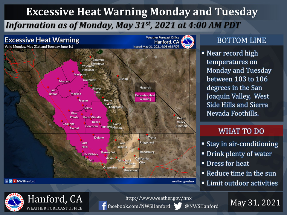
May 31, 2021 - The National Weather Service Hanford Office reports an Excessive Heat Warning is now in effect for the Southern San Joaquin Valley, West Side Hills, and Sierra Nevada foothills from 12:00 P.M. Monday afternoon until 8:00 P.M. Tuesday evening.
An Excessive Heat Warning means that a prolonged period of dangerously hot temperatures will occur.
Heat related illnesses, such as heat exhaustion and heat stroke are likely.
Drink plenty of fluids, stay out of the sun, stay in an air-conditioned room, and check up on relatives and neighbors.
  Area Forecast Discussion...UPDATED
  National Weather Service Hanford CA
  334 PM PDT Sun May 30 2021

  ...Update to Air Quality Issues Section...

  .SYNOPSIS...A few thunderstorms remain possible in the Sierra
  until sunset today. Dangerously hot temperatures will impact a
  majority of the central California interior Memorial Day through
  Wednesday. Temperatures are expected to be around 12-17 degrees
  above normal with some new record highs possible in parts of the
  San Joaquin Valley. Some cooling will occur later in the week but
  afternoon temperatures will remain well above normal.

  &&

  .DISCUSSION...
  Visible satellite imagery shows lots of cumulus clouds developing
  over the southern Sierra Nevada this afternoon as a weak upper low
  spins over southern California and northern Baja CA. Radar detects
  some light showers mainly over Sequoia National Forest in Tulare
  County but extending as far south as Lake Isabella in Kern County.
  Hi-Res models suggest this activity will continue for a few more
  hours before diminishing by sunset. There is still a small chance
  of an isolated thunderstorm or two as well.

  An East Pacific ridge of high pressure is beginning to build inland
  over northern California. This has resulted in some warming today
  as 24 hour trends are running up 2-5 degrees. Highs are forecast to
  top out in the mid 90s across the SJ Valley this afternoon, around
  5-10 degrees above climatological normals for the end of May. The
  ridge continues to build inland Monday for more significant warming.
  Widespread triple digit heat will occur across the lower elevations,
  with afternoon highs forecast to range from 101-107 degrees, around
  12-17 degrees above normal. Some record highs may be tied or broken
  in parts of the SJ Valley. Tuesday looks to be a near carbon copy.
  An Excessive Heat Warning is in effect for the San Joaquin Valley,
  the West Side Hills, and the Sierra Foothills for Monday and Tuesday.
  An Excessive Heat Watch is in effect for the same areas on Wednesday
  as temperatures only lower slightly.

  Ensembles shift the ridge to the east later in the week as an upper
  trough moves over the Pacific Northwest. Temperatures will lower a
  few degrees both Thursday and Friday but afternoon highs are still
  expected to around 7-10 degrees above normal by Friday. Next weekend
  looks to remain
.AIR QUALITY ISSUES...
  On Monday May 31 2021... Unhealthy for sensitive groups in Fresno...
  Kern... Kings and Tulare Counties and Sequoia National Park and
  Forest.

  Further information is available at Valleyair.org
Source: NWS

