


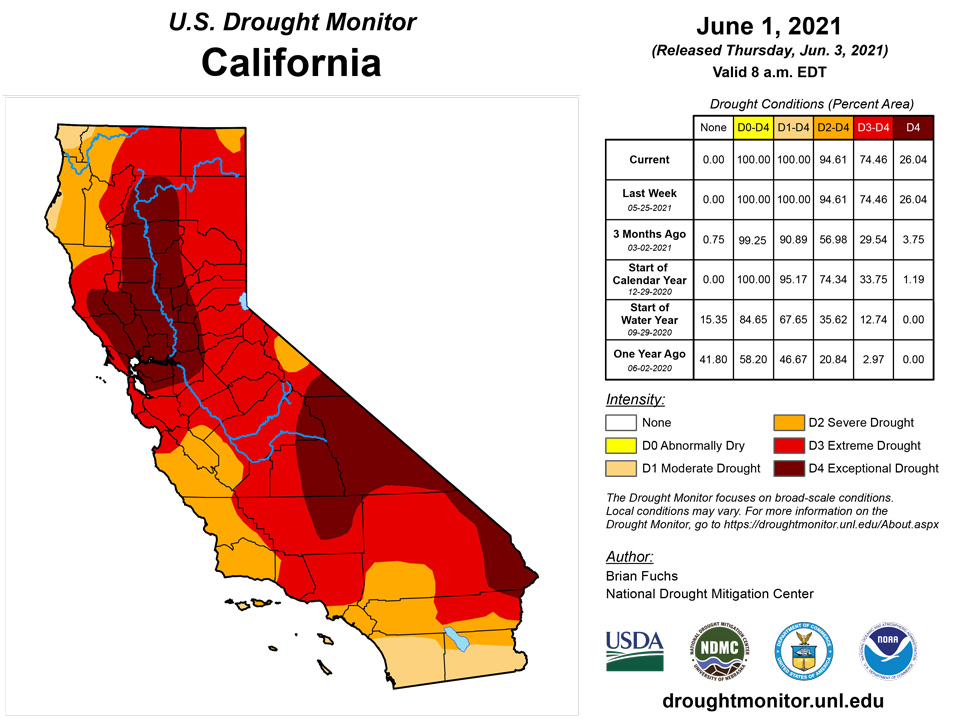
California and National Drought Summary for June 1, 2021
Summary
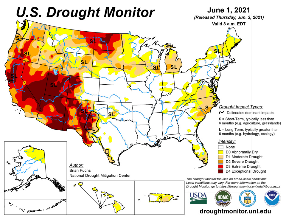
June 3, 2021 - Precipitation this past week was most active in the southern Plains and the Mid-Atlantic into the Northeast, helping to ease and improve drought in those regions. Some precipitation also occurred in the South and portions of the Midwest, but the Southeast and Southwest remained dry through the week. For the time of year, temperatures were well below normal over most of the country, with departures of 9-12 degrees below normal in the Dakotas. Portions of the Southeast and Southwest did have pockets of above-normal temperatures, but even those areas were close to normal.
Northeast
Temperatures in the Northeast were below normal for the week, with departures of 2-4 degrees below normal widespread. Precipitation was significant, especially along coastal regions from Delaware up to Massachusetts where 200-300 percent of normal precipitation was recorded, although the northern portions of the region were dry. The cooler temperatures and significant rains allowed for some improvements this week and a couple of areas had some dryness introduced. Abnormally dry conditions were added in northern New York as well as in eastern Maine with ongoing dryness in these regions. Improvements to abnormally dry conditions were made across eastern Pennsylvania, northern New Jersey, southern New York and western Connecticut. In the Mid-Atlantic, abnormally dry conditions also improved over Delaware, Maryland and portions of northern Virginia. Due to ongoing dryness, moderate drought was expanded over most of central Virginia and abnormally dry conditions were expanded over eastern sections of West Virginia.
Southeast
Another dry week over much of the region, with only pockets of precipitation over southern Alabama into western Georgia and western North Carolina. What helped was that temperatures were below normal through much of the region too, with only areas of the Carolinas being 2-3 degrees above normal for the week. The wet season has been slow to arrive in Florida, with many locations having a significantly dry May. In North Carolina, moderate drought was expanded over the north central portion of the state with abnormally dry conditions expanded over the west. Severe drought was introduced in the southern part of North Carolina while some isolated intense rain allowed for some improvements to moderate drought over coastal North Carolina. For South Carolina, a new area of severe drought was introduced along the northeast portion of the state with abnormally dry conditions expanded in the south and west. Georgia had an expansion of abnormally dry conditions in the east while a new pocket was added in the south central portion of the state. Abnormally dry conditions were expanded over far northwest Alabama as well as in central Florida. In south Florida, moderate drought expanded as well as abnormally dry conditions.
South
Much of the region had abundant precipitation during the week with many areas recording over 200 percent of normal rain. Along with the precipitation, cooler than normal temperatures were widespread with most areas 3-6 degrees below normal for the week. The ongoing wet pattern allowed for continued improvements over most of Texas during the week, with most areas having a full reduction of the previous drought intensity level. Southeast Oklahoma had moderate drought and abnormally dry conditions removed while portions of western Oklahoma also had abnormally dry conditions improve.
Midwest
Cooler than normal temperatures dominated the region this week with most areas 2-6 degrees below normal. Dry conditions dominated Iowa, northern Minnesota, northern Wisconsin into the upper peninsula of Michigan, and southern portions of Indiana and Ohio. In the northern portions of Illinois, Indiana, and Ohio, improvements to abnormally dry and moderate drought conditions were made in response to a series of rain events. Severe drought was expanded in northern Illinois and into southern Wisconsin. Abnormally dry conditions were expanded over portions of southern Indiana, southern Ohio, eastern Kentucky and southwest Kentucky for the week. Areas of abnormally dry conditions were improved over southern Illinois and northern Missouri while an expansion of these conditions was made in southeast Missouri.
High Plains
Temperatures were 4-6 degrees below normal, with even greater departures in the Dakotas where some areas were 8-10 degrees below normal for the week. Much of eastern Colorado, southern Nebraska, Kansas and northwest South Dakota into southwest North Dakota received well over 150% of normal precipitation for the week. In Nebraska, abnormally dry conditions were improved over the north central, southwest and extreme southeast portions of the state while moderate drought expanded over northeast Nebraska. Severe drought was introduced over southeast South Dakota, with an expansion of moderate drought and abnormally dry conditions too. Southern Kansas and eastern Colorado had improvements to abnormally dry and moderate drought conditions while Wyoming had a mix of improvements and degradations to moderate and severe drought in the state.
West
The warmest temperatures in the region were over California and Nevada, where departures for the week were 3-6 degrees above normal. Most of the rest of the region was near normal for temperatures. Most of the West was dry for the week but eastern New Mexico and western Montana received enough precipitation to allow for some improvements to their drought status. Impacts are building in the region with water cutback anticipated on Lake Mead as it is currently 37% full and fell below the critical 1,075-foot level triggering cutbacks to Arizona, Nevada, and Mexico. Abnormally dry and moderate drought conditions were improved over western Montana while New Mexico had a large area of exceptional drought improve due to recent rains. In Washington, conditions continue to dry out, and abnormally dry and both moderate and severe drought conditions continued to expand.
Caribbean
There were no changes made to Puerto Rico this week.
Severe drought persisted across the U.S. Virgin Islands this week as dry conditions continued to affect the islands. The weekly rainfall totals were less half an inch of rain across the islands. The May 2021 rainfall total at the Cyril E. King Airport on St. Thomas was 2.45 inches or 81.1% of normal, while the year-to-date rainfall total of 7.97 inches was 67.9% of normal. SPI values for the 6-month period was -1.32, which is indicative of severe drought. The other monthly periods were indicative of drought free conditions. Similarly, the Henry E. Rohlsen airport on St. Croix had a monthly total of 1.47 inches, which is 40.6% of normal and its year-to-date was 56.7% of normal. SPI values at the 3, 6, 9, and 12-month periods were indicative of moderate to severe drought. According to reports from locals, warm and dry conditions have contributed to lower water levels across parts of St. Thomas and St. Croix.
St. John’s May 2021 rainfall total was 1.92 to 2.56 inches, depending on the CoCoRaHs station. The SPI values at the 1, 3, 6, and 12-month periods were indicative of abnormally dry to extreme drought. According to data records for Windswept Beach, each month during January through May had below-average rainfall, which has only happened three other times (1994, 1995, and 2019).
Pacific
There were no changes made to Alaska or Hawaii this week.
The weather features across the U.S.-Affiliated Pacific Islands (USAPI) during this USDM week (05/26/21-06/01/21) included a monsoon trough across western Micronesia, trade-wind convergence across eastern Micronesia, and upper-level troughs or lows north of the region. Divergence aloft associated with the upper-level systems enhanced showers generated by the surface convergence. The trade-wind convergence at times attempted to develop into an Inter-Tropical Convergence Zone (ITCZ). Weak circulations and surface troughs migrated east to west across the region within the surface features. Two circulations were labeled invest areas (90W and 99W) with one (99W) developing into a tropical storm (04W - Choi-Wan) west of Palau late in the week. As 90W moved south of Guam at the end of the week, its surface convergence was enhanced by divergence aloft to bring rain to the Marianas. South of the equator, a strong ridge of high pressure brought dry weather to American Samoa. The only rain came in light showers embedded within the resulting northeasterly winds.
Satellite-based estimates of 7-day precipitation (QPE) are available from two products: one using mainly infrared (IR) sensors (NESDIS GOES-R AHI) and the other incorporating microwave sensors (GPM IMERG). These QPE products showed two bands of precipitation originating over the Philippines and Indonesia region, one extending eastward across Micronesia and the other extending southeastward south of the Samoan Islands. Much of Micronesia was covered by 2+ inches of rain, with embedded areas of 4+ inches. The rain bands spread north-south from the equator to the Marianas in western Micronesia, to between roughly 2 and 8 degrees North latitude across the Marshall Islands (RMI) in far eastern Micronesia. The band of precipitation south of the equator was associated with the South Pacific Convergence Zone (SPCZ). The QPE showed 2+-inch bands of SPCZ precipitation well southwest of the Samoan Islands, with a thumb of lesser amounts (only a few tenths of an inch) extending across American Samoa.
Drought free conditions persisted across Palau as rainfall totals for the week were over 2 inches and the May rainfall total was over 21 inches.
Most of the Marianas had a wet week, with rainfall totals above the 1 inch weekly threshold to meet most water needs. Rota had the most rain at 2.85 inches. Saipan's ASOS station had the least rain with only 0.81 inch of rain this week, however the manual gauge and NPS stations had 1.11 and 1.65 inches, respectively. This wet week was enough to help improve the drought classification across the Marianas to drought free conditions.
This was also a wet week for the Federated States of Micronesia, with several locations receiving over 6 inches of rain. Chuuk and Lukunoch had the most rainfall at 7.89 and 13.38 inches for the week, respectively. All locations continue to be drought free, with the exception of Kapingamarangi. Although Kapingamarangi has received beneficial rains the last few weeks, resulting in a May rainfall total of 15.53 inches, long-term abnormally dry conditions persisted as it still recovers from the long-term drought impacts.
Across the Marshall Islands, Majuro, Jaluit, and Mili had over 2 inches of rain, securing another week of drought free conditions. Kwajalein, Ailinglaplap, and Wotje had the least precipitation this week. Local reports stated that recent rains have brought some relief to Wotje, with greenery evident across all parts of the atoll and water scarcity is not an issue at this time. For this, a one-category drought improvement was made to Wotje. Kwajalein had only 0.69 inch of rain this week, however, its May rainfall total of 8.45 inches was enough to prompt a one-category drought improvement (D-Nothing). For a third consecutive week, Ailinglaplap had less than an inch of rain at 0.75 inch. The May rainfall total was only 3.03 inches, which is less than the monthly threshold of 8 inches to meet most water needs. However, drought free conditions continued as there were no reports of drought impacts in the region.
This was a dry week for American Samoa. Pago Pago had no rain and Siufaga Ridge and Toa Ridge had only 0.14 and 0.17 inch of rain, respectively. Although each of these regions had little to no rain, drought free conditions continued since the monthly rainfall total was over the 4 inches threshold to meet most water needs.
Looking Ahead
Over the next 5-7 days, it is anticipated that much of the West as well as the central Plains will remain dry. The southern Plains and portions of the Carolinas are expected to see the most rain. Warmer than normal conditions are supposed to dominate the West and into the northern Plains, with departures of 12-15 degrees above normal in portions of California and Nevada. Cooler than normal temperatures are expected over the southern Plains and South in response to the anticipated rain.
The 6-10 day outlooks show the majority of the country has above normal chances of recording temperatures above normal during the period with the northern Plains, upper Midwest, and into the Northeast having the greatest likelihood. Cooler than normal temperatures are expected over Alaska, the West Coast, and into the southern Plains. It is anticipated that dry conditions will continue to dominate the Plains and West with the highest likelihood over the Great Basin. The greatest odds of above normal precipitation will be along the Mississippi Valley and into the southern Plains.
Author(s):
Brian Fuchs, National Drought Mitigation Center
Ahira Sanchez-Lugo, NOAA/NCEI
Dryness Categories
D0 Abnormally Dry—used for areas showing dryness but not yet in drought, or for areas recovering from drought.
Drought Intensity Categories
D1 Moderate Drought
D2 Severe Drought
D3 Extreme Drought
D4 Exceptional Drought
Drought or Dryness Types
S Short-term, typically less than 6 months (agriculture, grasslands)
L Long-term, typically more than 6 months (hydrology, ecology)
SL Area contains both short- and long-term impacts
Source: National Drought Mitigation Center

