


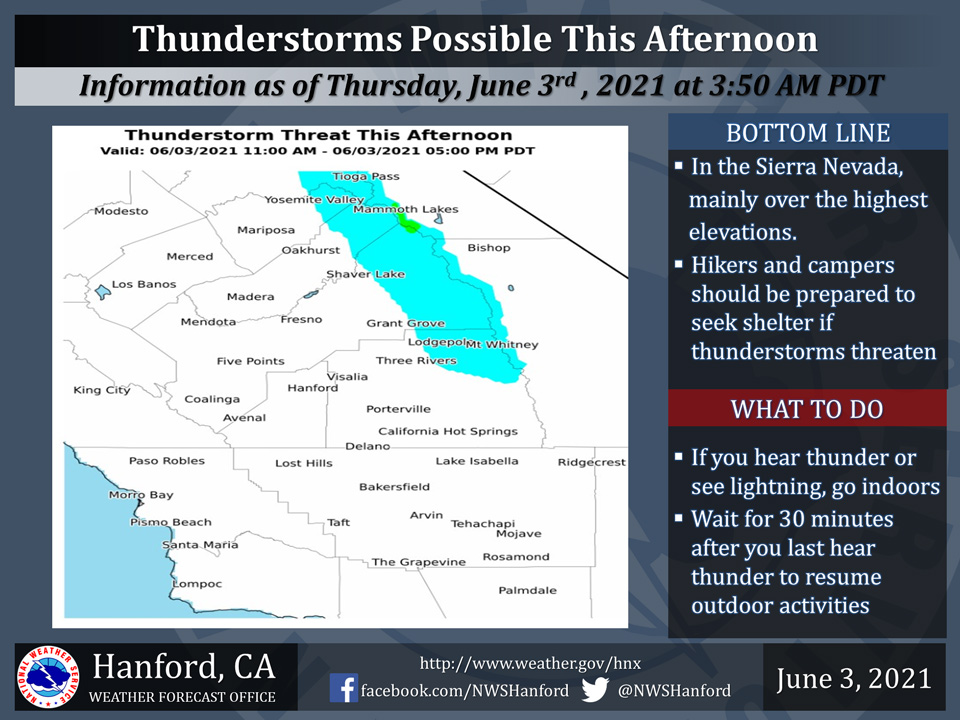
June 3, 2021 - The National Weather Service Hanford Office reports a few thunderstorms are possible in the blue shaded area this afternoon.
This includes primarily the higher elevations of the Sierra.
In addition to dangerous cloud to ground lightning, some thunderstorms can bring small hail, gusty winds and briefly heavy rain.
When clouds grow ominous and threatening, be ready to seek shelter, preferably indoors.
  Area Forecast Discussion
  National Weather Service Hanford CA
  450 AM PDT Thu Jun 3 2021

  .SYNOPSIS...Triple digit heat can be expected over much of the
  San Joaquin Valley, lower foothills and the Kern County desert
  through the end of the week. There is a slight chance of afternoon
  and early evening showers and thunderstorms near the Sierra crest
  today and a few showers are possible near the Sierra crest on
  Friday. Otherwise, dry weather will prevail over the area for the
  next several days. High temperatures will trend lower each day
  Saturday through early next week and will be below normal by
  Tuesday.

  &&

  .DISCUSSION...The large high amplitude ridge that has been
  responsible for the near record heat over our area for the past
  three days is now centered over central CA this morning and will
  provide our area with another day of widespread triple digit heat
  although most of the record high maximum temperatures look safe
  for today. Probabilistic guidance is indicating that Fresno has
  only a 3 percent chance of tying or breaking it`s record high
  temperature of 107 DEG F today while Bakersfield has zero chance
  of tying or breaking it`s record high temperature of 109 DEG F
  today. Although most of today`s records appear to be safe,
  temepratures remain well above normal for early June and heat
  impacts will continue to be felt across the area. An excessive
  Heat warning remains in effect for the Kern County Deserts and for
  the Bakersfield area from noon today until 800 PM PDT today while
  a Heat Advisory remains in effect for much of the remainder of
  the San Joaquin Valley and for the West Side Hills as well as the
  Sierra foothills from noon today until 800 PM PDT today. The other
  concern for today besides the triple digit heat is the potential
  for afternoon and evening thunderstorms over the higher elevations
  of the Sierra Nevada today.

  The ridge is progged to begin shifting east tonight while an
  onshore flow becomes established across our area. Lowering
  heights and thicknesses will result in less coverage of near
  record high temperatures on Friday as temperatures trend
  downward. SREF is indicating an onshore flow becomes established
  on Friday as well which will push most of the lingering moisture
  over the Sierra Nevada to the east of our area. on Satruday, an
  upper low is progged to drop southward near 130W while the ridge
  continues to shift east and further away from our area. This will
  allow for a few more degrees of cooling with highs in the San
  Joaquin Valley expected to be near the century mark on Saturday.

  The medium range models and their ensemble means are indicating a
  zonal westerly flow over the PAC NW Sunday through providing
  central CA with a more pronounced onshore flow. This will allow
  for a significant cooling trend to take place across our area with
  daytime temperatures plunging to near normal levels by Monday. A
  fairly strong upper low off the PAC NW coast will maintain a
  strong onshore flow pattern across central CA on Tuesday and
  Wednesday. Although moisture sufficient for precipitation will
  remain well to the north of our area, temperatures will continue
  lower and are expected to be slightly below normal for the middle
  part of next week.

  &&

  .AVIATION...Areas of MVFR and local mountain obscuring IFR in the
  Sierra Nevada in showers and thunderstorms between 18Z Thu and
  01Z Fri. Otherwise, VFR conditions can be expected throughout the
  central CA interior for at least the next 24 hours.

  &&

  .AIR QUALITY ISSUES...On Thursday June 3 2021... Unhealthy for
  sensitive groups in Fresno... Kern and Tulare Counties and Sequoia
  National Park and Forest. Further information is available at
  Valleyair.org
Source: NWS

