


California and National Drought Summary for June 15, 2021
Summary
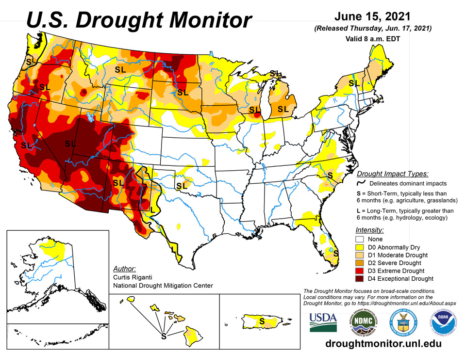
June 17, 2021 - Warmer than normal temperatures continued their hold this week on the northern tier of the Lower 48, particularly in the northern Great Plains and Upper Midwest. Across the north, widespread degradation of drought conditions occurred in areas where heavy rainfall missed. A few areas that received heavy precipitation and saw localized improvements were coastal Oregon and Washington, western Montana, and eastern Montana and western North Dakota. Widespread heavy rain occurred in the Southeast and Mid-Atlantic, where drought conditions improved or ceased in many locations. Scattered storms over the last few weeks in the southern Great Plains and eastern New Mexico led to isolated improvements to drought conditions, and a few degradations to drought conditions in western Oklahoma where heavier storms missed. Conditions improved after beneficial rainfall in eastern Puerto Rico. Continued drying in Hawaii led to degradation in drought conditions on many of the islands.
Northeast
Rain fell across much of the southwestern half of the region, leading to improving conditions in some areas, while conditions remained the same or worsened in northern New England and alongside the eastern Great Lakes. Moderate drought developed in northern New York, where short-term precipitation deficits mounted, soil moisture decreased, and streamflow lessened. A similar story played out in parts of Maine, where widespread degradation to moderate drought and abnormal dryness occurred. A small area of moderate drought also developed on Cape Cod, where short-term precipitation deficits grew and streamflow dropped. Heavy rain fell in West Virginia and Virginia, where conditions improved enough for the removal of moderate drought in most parts of Virginia (excluding far south-central reaches of the Commonwealth).
Southeast
The rainfall this week allowed drought conditions to improve, sporadically, from South Florida to North Carolina. Moderate drought lessened in coverage along the southwest Florida Gulf Coast after heavy rain fell this week and improved conditions there. Severe drought ceased in North Carolina and decreased in coverage in South Carolina after recent heavy rain. Moderate drought coverage was also reduced across a wide swath of eastern South Carolina and eastern North Carolina.
South
Scattered heavy rain fell across the eastern half of the region this week, while rains were much spottier (though locally heavy) in Texas and Oklahoma. Moderate and severe drought conditions shifted northwest in western Oklahoma in response to changing conditions after rain this week, leaving some areas improved and others degraded. Several areas in southwest Texas saw improvement this week after rain from the last couple of weeks improved conditions there. In southwest Texas, the Trans-Pecos, and along the Rio Grande to near Laredo, abnormal dryness and all drought categories continued.
Midwest
Generally warm and dry conditions prevailed in the northern half of the region over the past week, leading to widespread worsening of drought and dryness. Continued warm and dry weather worsened precipitation deficits in the western and northern parts of Chicagoland, as well as in adjacent southeast Wisconsin, and extreme drought developed in those areas. In this general region, many crops are struggling due to the ongoing severe and extreme drought. Moderate drought also developed across central Wisconsin as short-term precipitation deficits mounted. Moderate drought coverage also grew in western regions of Minnesota. Drought coverage also expanded across a large portion of southern Iowa. Recent dry weather and lowering streamflow led to the development of moderate drought in St Louis County, Missouri. In northern portions of Wisconsin and the Michigan Upper Peninsula, rain this week kept encroachment of drought or abnormal dryness at bay. Conditions were also better in the Ohio River Valley, where some small areas of abnormal dryness lessened their aerial grip after rain this past week.
High Plains
Precipitation across the High Plains region varied significantly this week, though very warm temperatures were consistent across the region. Notably, many places in the central and northern Great Plains have had warmer daytime high temperatures than much of the southern Great Plains, leading to potentially large losses of surface moisture to the atmosphere through evaporation and transpiration in the northern Great Plains. A few areas in the western half of North Dakota received enough rain from several thunderstorm events to improve their drought status, though this primarily occurred in areas with very heavy rain amounts (some locales received over 5 inches). For the most part, while welcome, the heavy rains have come after months of warm and dry conditions, and the widespread severe, extreme, and exceptional drought has been slow to improve as impacts to plants and livestock continue. In north-central and northeast South Dakota, and adjacent portions of North Dakota, moderate and severe drought expanded.
West
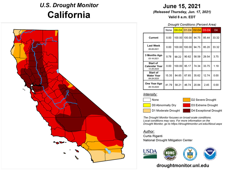
Three notable widespread precipitation events occurred in the northwestern United States this week, which led to limited improvements in northeast Montana, western Montana, and coastal regions of Washington and Oregon. Recent scattered rainfall from thunderstorms in the high plains and high desert of eastern and south-central New Mexico improved drought conditions locally, though widespread moderate-to-exceptional drought maintained its grip on most of the state. Northeast Montana received locally enough rain from severe thunderstorms for limited improvement from extreme to severe drought. However, similar to North Dakota and South Dakota, agricultural impacts and warm temperatures continued, limiting the rain’s benefit on conditions in the area. A swath of precipitation covered areas from southwest Idaho to the high country of western Montana, leading to a small area of improved conditions in western Montana. Finally, a late-season atmospheric river event delivered welcome precipitation to coastal portions of Washington and Oregon, which improved short- and long-term precipitation deficits enough for localized one- and two-category improvements in drought conditions. Unfortunately, most of the rest of the West received little to no precipitation, and warmer than normal temperatures plagued much of the region. Degradations to conditions occurred in northeast California and south-central Oregon, southern Montana, central and western Wyoming, far east-central Wyoming, and the high country of west-central Colorado. All of these locations saw short- and long-term precipitation deficits continue to mount. Most of the West region remained in moderate, severe, extreme, or exceptional drought. In central California, farmers have been warned about potential water cutoffs, while wildfire concerns and firework restrictions are prevalent in Utah, Arizona, and New Mexico.
Caribbean
Beneficial rains fell this week in Puerto Rico; as a result, streamflow increased and short-term precipitation deficits lessened, and moderate drought and abnormal dryness decreased in coverage.
Drought persists across the U.S. Virgin Islands, but there has been some limited improvement over the past few months. The recent uptick in rainfall prompted an improvement to D1 at St. John, joining St. Thomas, which was improved to D1 earlier in the month. St. Croix remains in severe drought (D2).
For June 1 – 15, St. Thomas reported 1.58 inches of rain, about a half-inch above normal. Although rainfall has totaled only slightly below normal since April, December – February brought only 3.93 inches of rain, compared to a normal of 8.19 inches. So continued near to above normal rainfall is needed for more improvement.
St. John recorded 2.35 inches of rain for the first half of June, almost 65 percent above the normal. Reports indicate that vegetation is significantly greener than a few weeks ago, which also supports the improvement to D1. Still, only two-thirds of normal has fallen so far this calendar year, so continued and consistent normal to surplus rainfall will be needed to engender further improvement.
As opposed to St. John and St. Thomas, St. Croix has not experienced as significant an increase in recent rainfall. The first half of June brought only 0.84 of an inch of rain, about 90 percent of normal. Also, subnormal rainfall has been in place longer at St. Croix, with less than normal rainfall each month since September 2020. During September 2020 – mid-June 2021, 19.81 inches of rain have fallen on St. Croix, compared to a normal of over 30 inches. With dryness in place longer, and no recent uptick in moisture, St. Croix remains at D2 despite improvement elsewhere.
Pacific
No changes were made to this week’s depiction in Alaska, where abnormally dry conditions continued in the northern reaches of the state. In Hawaii, abnormal dryness and moderate drought continued on Niihau, Kauai, and Oahu. Severe and moderate drought advanced eastward on Molokai, where farmers are beginning to supplement feed due to poor forage conditions. One-category degradations to moderate and severe drought were made on Lanai, where vegetation health worsened this week. Moderate and severe drought continued on Kahoolawe. On Maui, moderate and severe drought became more widespread, as paltry rainfall and poor streamflow have attracted feral deer to farm lots, leading to crop damage. Moderate drought also grew in coverage on Hawaii, where brush fires have been occurring as a result of drying conditions.
Last week (Jun 9-15, 2021) surface troughs providing low-level convergence were coupled with upper-level divergence. A monsoon trough was established at times over western Micronesia while trade-wind convergence, with a modest Inter-Tropical Convergence Zone (ITCZ) at times, covered central to eastern Micronesia. A few weak and transient low pressure systems mainly affected western parts of the region while a weak frontal boundary meandered around the Marianas. South of the equator, a frontal boundary passed over the Samoan Islands, bringing a few days of intermittent heavy rain.
Satellite-based rainfall estimates showed two broken bands of rainfall, one extending from Indonesia eastward across Micronesia to beyond the Date Line, and another from Indonesia southeastward through the Samoan Islands. Rainfall totaled 1 to locally over 2 inches in scattered areas across Palau, Yap, parts of the Marshall Islands, northern parts of the Marianas, and southern portions of Chuuk, Pohnpei, and Kosrae. Less than an inch of rain fell across southern parts of the Marianas, most of the Marshall Islands, and northern parts of Micronesia. Farther south, one to locally 4 inches or rain fell in bands across American Samoa.
Longer-term – the past several weeks to several months – most locations have received sufficient to abundant rainfall. In general, periods of deficient rainfall have been short-lived, and mitigated by heavier rains at other times. There have been a few notable exceptions, but as of mid-June 2021, no drought is indicated on any of the affiliated Pacific Islands, and only Wotje (northeast Marshall Islands) and Kapingamarangi (southernmost Micronesia) are experiencing some degree of dryness not rising to the level of drought.
Palau reports 3.92 inches of rain for the first half of June, which is less than 45 percent of normal. But this follows a January – May with over 75 inches of rain, which was more than 2 feet above (about 150% of) normal. Dryness and drought shouldn’t be a concern in the near future.
In contrast, rainfall has been near to slightly below normal across the Marianas. Saipan reports about 13.5 inches of rain so far this year, which is less than 2 inches short of normal. Other locations were similarly close to normal for January – May, though deficits were more noticeable at Rota Airport (15.17 inches of rain, about 69 percent of normal) and Tinian (11.85 inches, or 75 percent of normal). But the prior wet season (July – December 2020) brought adequate to surplus rainfall, generally ranging from 43 to over 75 inches. This was notably below normal only at Tinian, resulting in an 11-month (July 2020 – May 2021) total of 54.77 inches, about 75 percent of normal. Even there, however, rainfall was sufficient during the last half of 2020 to keep impacts in check for the time being.
Abundant rains have fallen on all but the extreme southern reaches of Micronesia since autumn 2020. Since October 2020, Kosrae has been soaked by over 209 inches of rain, which is 70 inches (50 percent) above normal. Yap received over 107 inches of rain during this period, about 37 inches (44 percent) above normal. Since the start of the calendar year, both sites reported 148 to 153 percent of normal – a surplus of 20 to 25 inches. North of Kapingamarangi, the 14 reporting stations received a median of 156 percent of normal for October 2020 – mid-June 2021) and 151 percent of normal since the start of the calendar year.
Kapingamarangi, located well south of the other reporting locations in Micronesia, has been a dramatic exception to the long-term wetness entrenched elsewhere. But even here, rainfall has increased over the past few months. Moisture shortages were most dramatic during the May 2020 – February 2021 period. Less than 39 inches fell during those 10 months, when the average exceeds 104 inches (37 percent of normal). A wetter pattern has prevailed since March, with the last 3.5 months bringing 30 percent more rain than the prior 10 months. Over 50 inches of rain fell March – mid-June 2021, somewhat more than the normal of 41.87 inches. Most drought-related impacts have been mitigated by the recent spell of heavy rain, but D0 (L) is maintained due primarily to lingering concerns about the quantity and quality of well water. Even including recent precipitation, Kapanamarangi rainfall totals from October 2020 to present remain about 65 percent of normal.
June to date has been drier than normal across most of the Marshall Islands. Jaluit reports 9.7 inches of rain for the first half of June, which is well above normal, but Ailinglaplap, Kwajelein, and Wotje have recotded 1.3 to 2.7 inches of rain, which is only 46 to 54 percent of normal. But from the start of the year through May, Ailinglaplap and Kwajelein reported 52.48 inches (148 percent of normal) and 28.14 inches (118 percent of norm), respectively, so dryness is not a concern at those locations. But at Wotje is at D0 (L) with subnormal rainfall dating back to December 2020. They report 14.63” of rain from December through mid-June 2021, which is about two-thirds normal. Looking merely at precipitation mathematics, one could argue for a drier depiction than D0 (L), but the degree of impacts can’t justify a drier designation.
In American Samoa, June 1 – 15 rainfall is well above normal, with Pago Pago reporting 5.82 inches of rain (almost double the normal). This follows 3 months (March through May 2021) of deficient precipitation, when 24.53 inches of rain fell, less than 75 percent of normal. However, each of the 7 months before that were wetter than normal. August 2020 – February 2021 featured over 108 inches of rain, more than 40 percent above the normal. So despite March-May dryness, heavier rains before and after this period have squelched dryness-related impacts in the near future.
Looking Ahead
As of June 16, the National Weather Service (NWS) Weather Prediction Center is forecasting two areas of significant precipitation through the evening of June 21. One area of forecast rain covers much of the Great Lakes and Ohio Valley regions, and could be highly beneficial to southern Wisconsin and northern Illinois if it occurs. Large rain amounts are also forecast from the central Gulf Coast to Georgia, northwest Florida, and western South Carolina, in association with a tropical disturbance being monitored by the NWS National Hurricane Center as of the afternoon of June 16th. For more information on this system, please monitor forecasts from the National Hurricane Center, the Weather Prediction Center, and your local National Weather Service forecast. The NWS Climate Prediction Center forecast for June 22-26 favors above normal precipitation in the western Great Lakes, lower Missouri River Valley, and the Southeast (excluding South Florida), while below normal precipitation is favored in the Pacific Northwest, Intermountain West, and North Dakota. During this period, warmer than normal temperatures are favored in the western Great Plains and West, while below normal temperatures are more likely from the Great Lakes to the central and eastern Gulf Coast). In Alaska, above normal temperatures are favored in the north from June 22-26, below-normal precipitation is favored in east-central Alaska, while above normal precipitation is favored elsewhere in the state.
Author(s):
Curtis Riganti, National Drought Mitigation Center
Richard Tinker, NOAA/NWS/NCEP/CPC
Dryness Categories
D0 Abnormally Dry—used for areas showing dryness but not yet in drought, or for areas recovering from drought.
Drought Intensity Categories
D1 Moderate Drought
D2 Severe Drought
D3 Extreme Drought
D4 Exceptional Drought
Drought or Dryness Types
S Short-term, typically less than 6 months (agriculture, grasslands)
L Long-term, typically more than 6 months (hydrology, ecology)
SL Area contains both short- and long-term impacts
Source: National Drought Mitigation Center
