


California and National Drought Summary for June 29, 2021
Summary
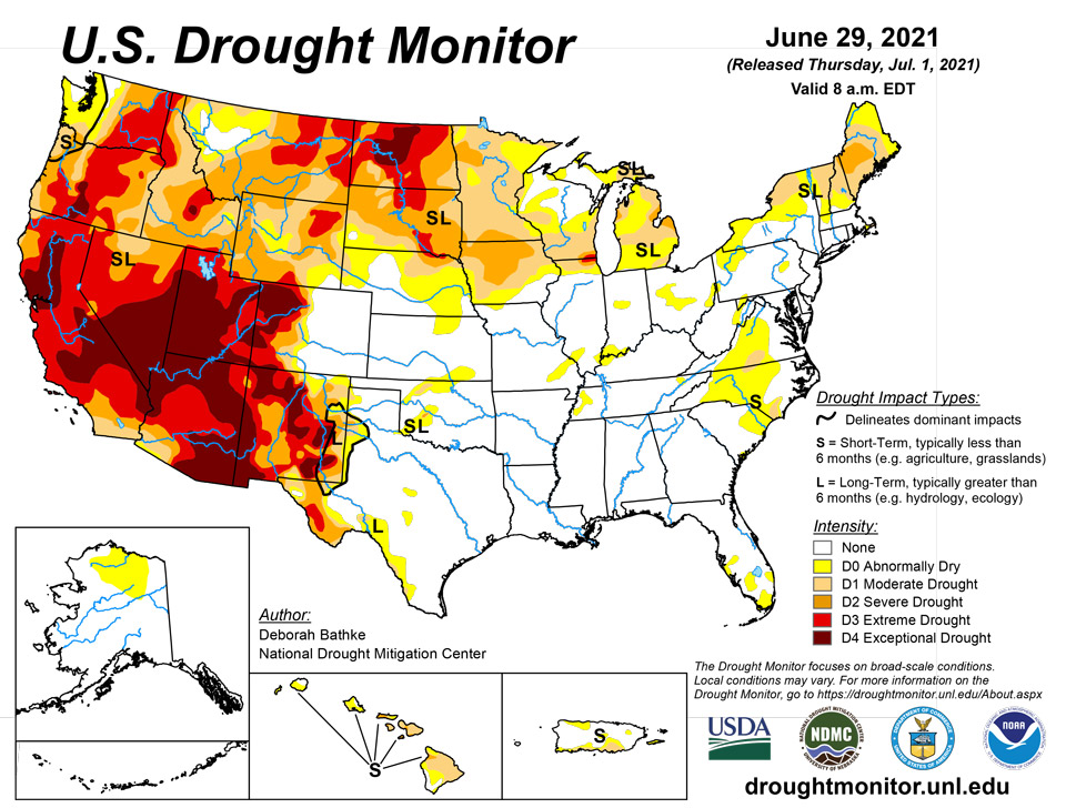
July 1, 2021 - This week’s U.S. Drought Monitor saw changes to over 30 states this week. Record-breaking heat in the Northwest, Great Basin, and Northeast led to expansions of drought conditions. Meanwhile, multiple rounds of heavy rain across the Central U.S. led to large-scale improvements, and intense rainfall along the Gulf Coast led to the reduction or removal of lingering pockets of abnormal dryness.
Northeast
Warm, dry weather across New England led to the expansion of moderate (D1) and severe (D2) drought where year-to-date precipitation is down more than 6 inches below normal. Multiple high temperature records were broken over the last couple of days and values have consistently ranked in the top 10 warmest over the last 90 days. The lack of rainfall, combined with the excess heat, has dried soils and lowered streamflows. Water conservation measures are in effect in parts of Maine, New Hampshire, and Vermont.
Southeast
Intense rainfall this past week left much of the region virtually drought-free. In areas that missed out on the heaviest rainfall, such as Virginia and North Carolina, pockets of moderate drought (D1) remain and areas of abnormal dryness (D0) expanded. Rainfall deficits of 2 to 8 inches in areas of those two states still exist over the past 90 days. State drought monitoring teams commented that ag reports continue to note moderately dry fields, which is apparent on satellite-based indicators of vegetation health, and that lake levels remain low.
South
A band of substantial rain (6 to 10-plus inches) fell from West Texas to northeast Oklahoma, leading to large areas of one-category improvements as well as some smaller areas of two-category improvements as short-term rainfall deficits, soil moisture, and streamflow improved. Drought and abnormal dryness remain in areas where indicators still show dryness at longer timescales. A re-evaluation next week will help determine the full effect of the rainfall.
Midwest
A stalled frontal boundary brought widespread, heavy rain (3 to 10-plus inches) and flash flooding to parts of the lower Midwest. The excess moisture led to a general one-category improvement to drought conditions as short-term rainfall deficits decreased and streamflow and soil moisture improved. In the Upper Midwest, which mostly missed out on the heaviest rain, drought remains a concern. In Minnesota, the U.S. Department of Agriculture (USDA) reports as of June 27, that 75% of the state’s topsoil moisture is short to very short, meaning that it’s significantly less than what is required for normal plant development. While crops can still improve with additional rain, the damage has already been done to pastures. Abnormal dryness (D0) expanded in Minnesota and moderate drought (D1) expanded in northern Illinois.
High Plains
The same stalled frontal boundary that affected the Lower Midwest this week also brought widespread rain to the region with the largest totals (2 to 8-plus inches) falling over eastern Kansas and eastern Nebraska. One-category improvements were made in southeast Kansas, eastern and north central Nebraska, and parts of North Dakota as short-term rainfall deficits decreased and streamflow and soil moisture improved. In Colorado, improvements were made to small areas of exceptional (D4) and extreme (D3) drought as recent rainfall has helped chip away at shorter term deficits. Hydrological and ecological drought, which generally occur on longer time scales, remain a concern. In areas which missed out on the heaviest rain, drought continues to impact the region with cattle producers feeling the brunt of the impacts. The USDA reports that 90% of South Dakota and 66% of North Dakota’s topsoil moisture is short to very short, leading to forage shortages. Producers from Wyoming eastward across the Dakotas are having to make tough decisions as to what to do with cattle, with many selling entire herds. In response to the worsening conditions, extreme drought (D3) expanded in South Dakota and parts of Wyoming where supported by increasing rainfall deficits, declining soil moisture and streamflow, and vegetation stress.
West
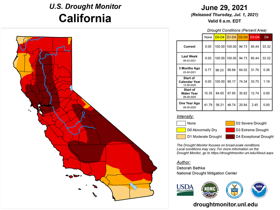
Unprecedented heat in the Northwest, combined with another week of dry weather, led to worsening drought conditions across the region. This week, high temperatures ranged from 20 to 30 degrees above normal, breaking multiple records. The excess heat greatly increased evaporative demand, further drying out soils and vegetation, and worsening conditions. Many areas in the Northwest saw one-category degradations, including expansions of severe (D2) and extreme (D3) drought. Conditions in the Southwest remained unchanged, except for the expansion of D3 in central Arizona. Much of the West is classified as severe drought or worse. Notable impacts include increased wildlife encounters in California, Nevada, and Utah, as drought has driven snakes and/or bears in search of food and water into urban areas in those states. In Montana, fishing restrictions have been put in place on many rivers due to low flows and warm waters. Drought-stricken ranchers are selling cattle due to poor forage conditions and a lack of feed. On top of this, grasshoppers have been denuding trees and competing with cattle for food. So far, at least eight national forests in the West now have fire restrictions.
Caribbean
In Puerto Rico, beneficial rains decreased deficits and improved drought conditions across the central and eastern parts of the Island. Meanwhile, rainfall deficits continued to build along the southern coast, leading to increases in abnormal dryness (D0) and moderate drought (D1).
The Cyril E. King airport in St. Thomas had 1.71 inches of rain and a month-to-date total that was 195.1% of normal. CoCoRaHS stations had a weekly rainfall total between 1.0-2.50 inches, with month-to-date totals between 4.0-6.0 inches. Year-to-date rainfall total at the airport was 88.2% of normal. SPI values for all timescales indicate drought free conditions. This week, a one-category drought improvement was made to St. Thomas.
Weekly rainfall totals for St. John were between 1.0-1.40 inches, depending on the CoCoRaHS station. Month-to-date rainfall totals were a little over 4 inches. Year-to-date rainfall total at the Windswept Beach was 70% of normal. SPI values for 6 (-0.89), 9 (-0.69) and 12-month (-0.64) were indicative of abnormally dry to moderate drought conditions. All other timescales were indicative of drought free conditions. Moderate drought continued across St. John.
Severe drought persisted across St. Croix as it received meager rain this week. The Henry Rohlsen airport had 0.48 inch of rain and a month-to-date rainfall total that was 91.9%. Year-to-date rainfall at the airport was 62.3% of normal. The CoCoRaHS weekly rainfall totals were between 0.09-0.17 inch, with a month-to-date between 0.96-1.94 inches. SPI values at the 3 (-0.65), 6 (-1.16), 9 (-1.44), and 12-months (-1.13) were indicative of abnormally dry to severe drought.
Pacific
In Alaska, no changes were made to the map this week.
In Hawaii, lighter than normal winds and lower than normal rainfall occurred over the past weeks. Rainfall totals along the windward slopes are below 50% of the June average and streamflows are declining. As a result, abnormal dryness (D0) expanded on Molokai and moderate drought (D1) expanded on the Big Island. Above normal rainfall on the southeast side of the Big Island led to the reduction of D0.
The weather features across the U.S.-Affiliated Pacific Islands (USAPI) during this USDM week (06/23/21-06/29/21) included a series of surface troughs that moved from east to west across Micronesia, accompanied at times by a couple weak circulations. An ITCZ (Inter-Tropical Convergence Zone) meandered at times across parts of central to eastern Micronesia. Upper-level lows and troughs (Tropical Upper Tropospheric Troughs, or TUTT cells) migrated east to west across northern parts of the region, mostly north of 10 degrees North latitude. Early in the week, Tropical Storm Champi (06W) spread rain across the Marianas as it exited the region, then later in the week surface troughs coupled with upper-level divergence to bring additional rain to the Marianas. South of the equator, a surface trough spread moisture across the Samoan Islands.
Satellite-based estimates of 7-day precipitation (QPE) are available from two products: one using mainly infrared (IR) sensors (NESDIS GOES-R AHI) and the other incorporating microwave sensors (GPM IMERG). These QPE products showed a band of precipitation stretching from Indonesia southeastward to the Samoan Islands and beyond (South Pacific Convergence Zone, or SPCZ) and areas of precipitation over Micronesia. The QPE indicated areas of 2+ inches of rain across American Samoa; southern Portions of Chuuk, Pohnpei, and Kosrae States in the Federated States of Micronesia (FSM) and southern portions of the Marshall Islands (RMI); Palau and western Yap State; and much of the central and northern portions of the Marianas.
Palau IAP had 2.98 inches of rain this week and 9.46 inches for the month-to-date, surpassing the weekly (2 inches) and monthly (8 inches) thresholds to meet most water needs. Drought free conditions continued across Palau.
Across the Marianas, Guam had the least rain this week at 0.63 inches. However, Guam’s month-to-date rainfall total was 4.80 inches, surpassing the monthly threshold of 4 inches to meet most water needs. Meanwhile, Saipan had the most rain with rainfall totals surpassing 2 inches and a month-to-date total that was over 5 inches. Both Guam and Saipan continued in drought free conditions. Rota had its fourth consecutive week with rainfall totals below the weekly threshold of 1 inch at 0.69 inch. Rota’s month-to-date is only 1.98 inches of rain, which is less than the threshold of 4 inches to meet most water needs. For this week, drought free conditions continued for Rota since no notable drought impacts were reported.
For the FSM, Yap, Kosrae, Chuuk Lagoon, Kapingamarangi, Nukuoro, and Pingelap had over 2 inches of rain this week, securing another week of drought free conditions. Meanwhile, Pohnpei, Lukunor, and Woleai had less than 2 inches of rain for the week. Most of these locations had a month-to-date rainfall total that surpassed the threshold of 8 inches or were close to the threshold. For this reason, drought free conditions continued as drought is not a concern at the moment for these locations.
Fananu and Ulithi had no data, so they were set to be missing.
Across the Marshall Islands, Ailinglaplap and Mili had the most rain this week, with rainfall totals over 2 inches. Majuro had a little less than 2 inches of rain this week. However, all three locations continued to be drought free. Kwajalein and Jaluit had the least rain at 0.46 and 0.42 inch, respectively. Jaluit's month-to-date was over 11 inches, so drought free conditions persisted. Kwajalein's month-to-date was a little less than 5 inches. However, since there were no notable drought impacts reported, drought free conditions will remain. Wotje continued to be abnormally dry this week as it only had 1.03 inches of rain and a month-to-date rainfall total of 2.49 inches. As of last week, no notable drought impacts were reported and it was stated that vegetation was green.
This was a wet week for American Samoa and drought is not a concern as the three locations had over 3 inches of rain this week.
Looking Ahead
The National Weather Service Weather Prediction Center forecast for the next five days (July 1 -4) shows that the prolonged heat wave is expected to continue across the interior sections of the Northwest and Northern Rockies and move into the Northern High Plains. In the East, a cold front is forecast to bring relief from the hot, muggy weather in the Northeast, Mid-Atlantic, and Southeast. As the front moves through the region, these areas can expect moderate to heavy rainfall and an increased chance of severe weather.
Moving into next week, the Climate Prediction Center six-to-10 day outlook (valid July 6-10) favors above normal temperatures across the West, Northern and Central Plains, Midwest, and Northeast. Below normal temperatures are most likely across the South, Southeast, and Alaska. Below normal precipitation is expected to continue across much of the west and Northern Plains, while above normal precipitation is favored across most of the rest of the Lower 48 and Alaska.
Author(s):
Deborah Bathke, National Drought Mitigation Center
Ahira Sanchez-Lugo, NOAA/NCEI
Dryness Categories
D0 Abnormally Dry—used for areas showing dryness but not yet in drought, or for areas recovering from drought.
Drought Intensity Categories
D1 Moderate Drought
D2 Severe Drought
D3 Extreme Drought
D4 Exceptional Drought
Drought or Dryness Types
S Short-term, typically less than 6 months (agriculture, grasslands)
L Long-term, typically more than 6 months (hydrology, ecology)
SL Area contains both short- and long-term impacts
Source: National Drought Mitigation Center
