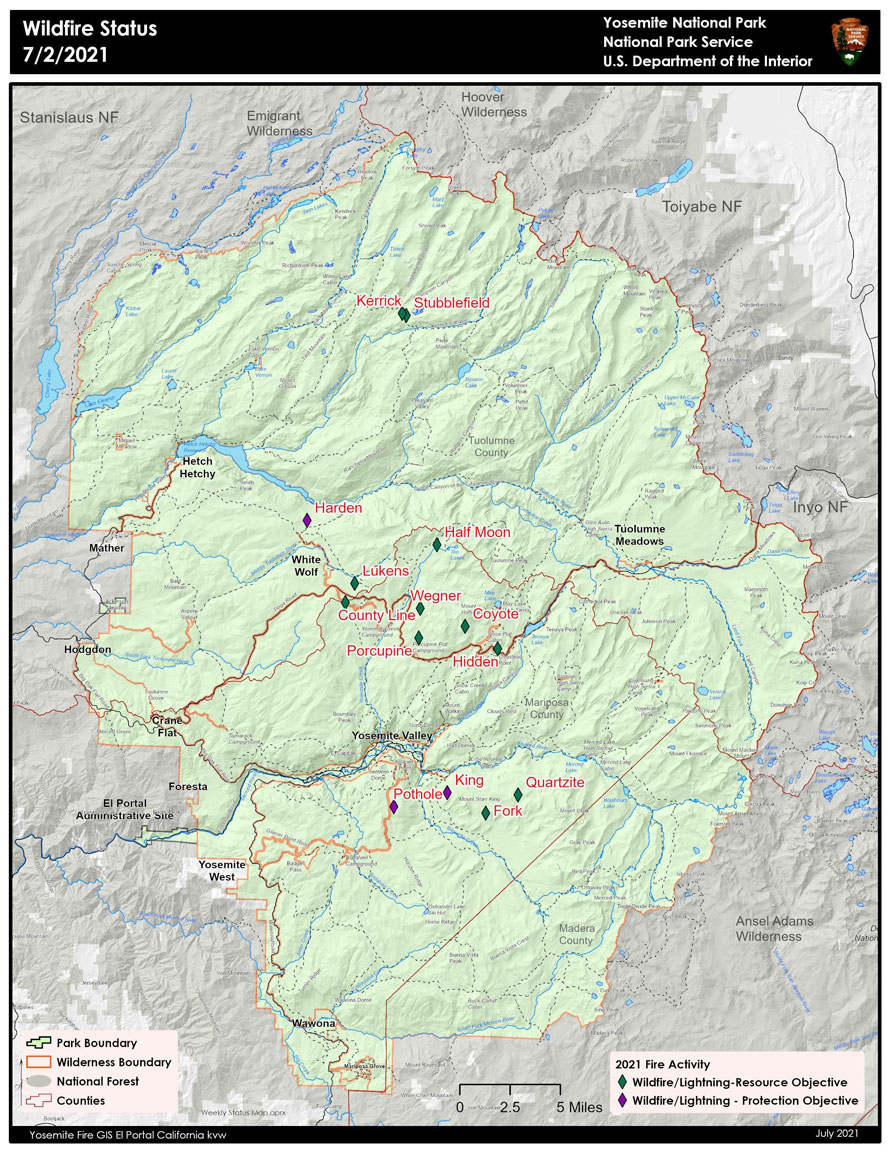
Current Fire in Yosemite National Park
July 4, 2021 - On Monday July 28, 2021 through July 2, thunderstorms developed over Yosemite National Park creating lightning that ignited 14 fires. Fire managers have been assessing all fires for an appropriate response. Due to the risk of visitor safety and park values three fires are being immediately suppressed. The King Fire in the Illilouette Creek drainage is being controlled by hand crews and helicopters. The Pothole and Harden fires are being extinguished by hand crews with support from a helicopter. The Kerrick Fire adjacent to the Pacific Crest Trail in the north end of the park has burned itself out in sparse fuels. The remaining fires are burning in high elevation areas located in wilderness ranging from 7,000 to 9,700 feet. Isolated afternoon showers and thunderstorms are possible through the 4th of July weekend then the weather is forecasted to be hot and dry into next week.
Yosemite National Park is a fire adapted ecosystem. The overall strategy for managing all wildland fires is to provide for the safety of employees and public, as well as protect and enhance natural and cultural resources.
Smoke maybe visible from areas along Tioga Road, Glacier Point Road and Yosemite Valley.
King
Location: South of Nevada Falls, north of Mount Starr King. 7220 elevation.
Discovery Date: June 29, 2021 Size: 8 acres
Containment: 5% Strategy: Suppression
Cause: Lightning
Quartzite
Location: West of Quartzsite Peak. 8781 elevation.
Discovery Date: June 29, 2021 Size: .30 acre
Containment: 0% Strategy: Monitor
Cause: Lightning
Harden
Location: North of Harden Lake, south of Hetch Hetchy. 6665 feet elevation.
Discovery Date: July 1, 2021 Size: .25 acre
Containment: 0% Strategy: Suppression
Cause: Lightning
Stubblefield
Location: Northern end of Yosemite NP, near Stubblefield and Kerrick canyons. 8000 elevation.
Discovery Date: June 28, 2021 Size: .1 acre
Containment: 0% Strategy: Monitor
Cause: Lightning
Porcupine
Location: Northeast of Porcupine Campground, and Tioga Road. 8210 elevation.
Discovery Date: June 28, 2021 Size: .10 acre
Containment: 0% Strategy: Monitor
Cause: Lightning
Coyote
Location: Coyote Rocks, north of Tioga Road. 9742 elevation.
Discovery Date: June 28, 2021 Size: .1 acre
Containment: 0% Strategy: Monitor
Cause: Lightning
Hidden
Location: Northwest of Olmsted Point, Tioga Road. 9017 elevation.
Discovery Date: June 28, 2021 Size: .1 acre
Containment: 0% Strategy: Monitor
Cause: Lightning
County Line
Location: Near Yosemite Creek Campground Road. 8361 elevation.
Discovery Date: June 28, 2021 Size: .1 acre
Containment: 0% Strategy: Confine and Contain
Cause: Lightning
Lukens
Location: West of Lukens Lake, North of Tioga Road. 8243 elevation.
Discovery Date: June 28, 2021 Size: .2 acre
Containment: 0% Strategy: Confine and Contain
Cause: Lightning
Wegner
Location: East of Yosemite Creek Picnic Area and east of Tioga Road. 8256 elevation.
Discovery Date: June 28, 2021 Size: .25 acre
Containment: 0% Strategy: Monitor
Cause: Lightning
Half Moon
Location: West of Ten Lakes near Half Moon Meadow. 8256 elevation.
Discovery Date: June 28, 2021 Size: .1 acre
Containment: 0% Strategy: Monitor
Cause: Lightning
Pothole
Location: South of Glacier Point Road. 7885 elevation.
Discovery Date: June 28, 2021 Size: .1 acre
Containment: 0% Strategy: Suppressed
Cause: Lightning
Fork
Location: 1 mile south of Ostrander Lake along Horse Ridge. 8500 elevation.
Discovery Date: June 28, 2021 Size: .3 acres
Containment: 0% Strategy: Confine and Contain
Cause: Lightning
Ridge
Location: South of Glacier Point Road, across from Sentinel Parking area. 8000 elevation.
Discovery Date: July 3, 2021 Size: .10 acre
Containment: 0% Strategy: Confine and Contain
Cause: Lightning
Lake
Location: West slope of Mt Hoffman. 9000 elevation.
Discovery Date: July 3, 2021 Size: .10 acre
Containment: 0% Strategy: Confine and Contain
Cause: Lightning


